Tuesday, December 1, 2020

ROMANIZED BERBERS DISAPPEARANCE

One of the biggest "disappearances" in History is the one that happened in northwestern Africa with the so called "Roman Africa", a region actually called "Maghreb" and that includes modern Tunisia and the Mediterranean areas of contemporary Morocco, Algeria and Libya's Tripolitania.

This area was one of the most romanized of the Roman empire in the fourth century, when started the barbarian invasions in western Europe: it was similar in everything to "Roman Hispania", according to the famous historian Theodor Mommsen.

Roman emperor Macrinus, a romanized berber born in Caesarea (now Cherchell in Algeria)

Roman Africa was populated by the autochtonous "Berbers" who were fully "latin speaking" in an area that coincides with actual central-northern Tunisia and who were fully christians on the coastal regions (from Gibraltar to modern Tripolitania).

There were also some descendants of the Phoenician settlers that founded Carthago, but they were assimilated by the autochtonous Berbers by the fourth century (indeed the same happened with some italian colonists that settled in coastal Numidia, mainly around Cirta).

But after the arrival of the Arabs in the late seventh century it "disappeared" in a terrible bloodbath. While Hispania remained forever linked to Rome, this African region lost nearly all the Romanization & the links with western Europe -from the local neolatin language to the early christianity (https://www.google.com/books/edition/The_Extinction_of_the_Christian_Churches/r1RbAAAAMAAJ?hl=en&gbpv=1&dq=christians+of+tunis&pg=PA241&printsec=frontcover).

However something of Roman Africa has survived, like the few Christian Berbers of our times and the small Spanish enclaves of Ceuta and Melilla

Indeed estimates show that actually there are nearly half a million Christian Berbers, many living in a situation of diaspora in Western Europe and the Americas and nearly 300,000 living in the Maghreb region of North Africa (from Morocco to Libya).

Notable Romanized Berbers

Accomplished Berbers of Roman Africa include famous writers such as Martianus Capella. There were also Christian saints such as Augustine, Roman popes such as Pope Victor I and even the pagan Roman emperors Macrinus & the famous Septimius Severus.

Most of them appeared in a socio-cultural period of development in Roman Africa following the introduction of Christianity. Most of these figures are historical, and we have to remember that now the Christians in North Africa do not have as much of a dominant community as they used to have in Roman times.

Roman writers such as Terentius, Lactantius, Martianus Capella (previously mentioned), Marcus Cornelius Fronto, Apuleius and Tertullianus were Berbers. Christian Berber saints include the Scillitan Martyrs, Cyprian, Victor Maurus and Saint Monica (mother of Saint Augustine). Roman popes like Pope Miltiades and Pope Gelasius I and Roman emperors such as Macrinus, Emilianus and Caracalla (son of the famous Septimius Severus) were also romanized Berbers.

Berber kings of exclusive Christian Berber realms known as the 'Romano-Berber states' include Masuna, Mastigas and Garmul of the "Kingdom of Altava", called initially "Mauro-Roman Kingdom" or "Kingdom of the Moors and Romans" (477-578 AD). They are known for making Christian Jedars and Mausoleums such as the "Tomb of the Christians" near Caesarea (also known as the 'Royal Mausoleum of Mauretania'). Also Caecilius (often called Koceila in berber language) of the Kingdom of Altava was an important Christian Berber.

History

The massacre of Christian Berbers by the Arab conquerors is one of the biggest exterminations in History. Nearly 90% of the Berbers living in actual Tunisia and Algeria "disappeared" in a few decades, with their own romano-berber civilization. Most of them died, but more than 350,000 were enslaved and sold in the slavery markets of the Arabs. A shameful genocide/ethnocide that only now is being studied and analyzed in all its enormous dimensions.


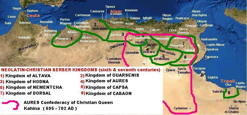
We know that the Kingdom of Altava (578-708 AD) fought harshly the Arabs. The last recorded ruler of the Kingdom of Altava was Caecilius, called Koceila or Kusaila ("leopard" in 'Tamazight' berber language). He died in the year 690 AD fighting against the Muslim conquest of the Maghreb. He was also leader of the Awraba tribe of the Imazighen and possibly Christian head of the Sanhadja confederation. Caecilius as a berber prince was probably educated in a roman christian way and consequently fought the moslem invasion with religious passion. He is known for having led an effective Berber martial resistance against the Umayyad Caliphate's conquest of the Maghreb in the 680s.

Indeed, in 683 AD the arab leader Uqba ibn Nafi was ambushed and killed in the Battle of Vescera near Biskra by Kusaila, who forced all Arabs to evacuate their just founded Kairouan and withdraw to Cyrenaica. But in 688 AD Arab reinforcements from Abd al-Malik ibn Marwan arrived under Zuhair ibn Kays. Caecilius met them in 690 AD -with the support of Byzantine troops- at the Battle of Mamma. Vastly outnumbered, the Awraba and Byzantines were defeated and Caecilius was killed. With the death of Caecilius, the torch of resistance passed to a tribe known as the Jerawa tribe, who had their home in the Aurès Mountains: his Christian berber troops after his death fought later under Kahina, the last Queen of the romanized Berbers.

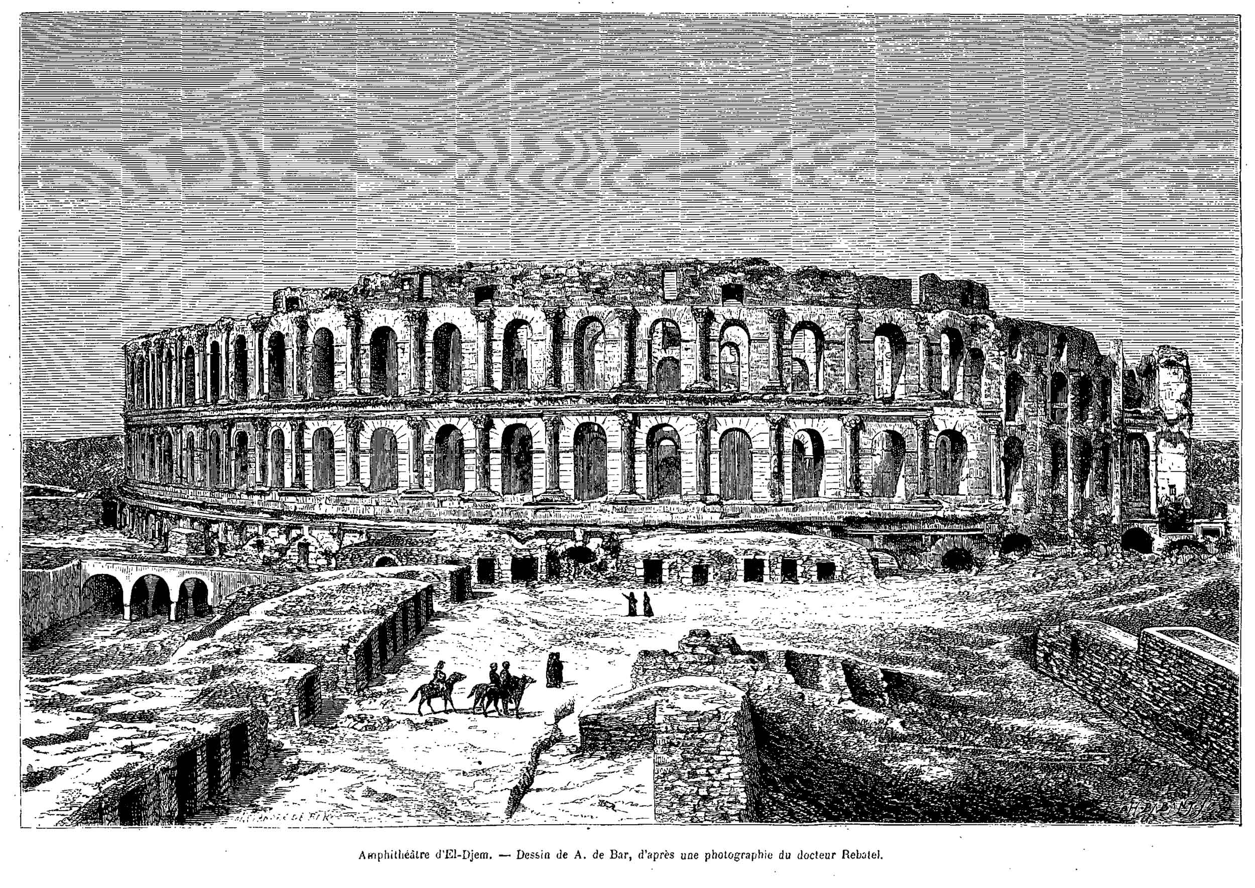
Kahina (called also Dihya) was born in the early 7th century and may well have been of mixed descent: Berber and Byzantine Christian, since one of her sons is described as a 'yunani' or Greek. Kahina ruled as a Christian queen (but some arab historians wrote that she was a Jewish "sorcerer") and was able to defeat the Arab invaders who retreated to Tripolitania: for more than five years ruled a free berber state from the Aures mountains to the oasis of Gadames (695-702 AD). But the Arabs, commanded by Musa bin Nusayr, returned with a strong army and defeated her. She fought at the El Djem Roman amphitheater of Thysdrus, but finally died around the beginning of the eight century (most probably in 703 AD) in modern-day Algeria in a battle near Tabarka. Her defeat and death was followed by the "disappearance" of Roman Africa in what the Arab conquerors later called 'Maghreb' (the word 'maghrib' means "western territories" in arab language).

Musa bin Nusair, a Yemeni general, was made governor of "Ifriqiya" (as Arabs called Roman Africa) and given the harsh responsibility of putting down this renewed romanized Berber rebellion and converting the population to Islam. Musa and his two sons prevailed over Queen Kahina and the rebels and enslaved 300,000 Berber captives. The caliph's portion was 60,000 of the captives. These the caliph sold into slavery (mainly in Damascus), the proceeds from their sale going into the public treasury. Another 30,000 captives (who rejected their Christian faith in order to survive) were pressed into military service and forced to convert to Islam.

We know that all Roman Africa had only one million inhabitants when Musa enslaved those 300,000 Berber captives....and this means that one third of the Romanized Berber population was reduced to slavery in those years! Furthermore 60,000 were sent mostly to Damascus. We know that in those years the Arabs did not have a huge navy, so most of those captives had to reach Damascus (in Syria) walking by foot thousands of kms! Imagine the massacre along the way through the desert of Libya and western Egypt! As an example, we know that in the XX century the moslem Turks forced many christian Armenians to walk a few hundred kms in captivity and there was the death of nearly one quarter of them: consequently imagine how huge was the massacre suffered by those Berbers enslaved, forced to walk in captivity the big distance between their homeland until Damascus....It was one of the most terrible exterminations of an entire population in ancient History!!!!


The El Djem Roman amphiteater was a stronghold of Queen Kahina: it was destroyed by the Arabs around 701 AD after a fierce defense by the romanized Berbers.

Historian Daniel Pipes also wrote in his famous book 'Slave Soldiers and Islam: The Genesis of a Military System' (https://books.google.com/books?id=ByLG-2hZX-MC&q=musa+300,000&pg=PA124#v=snippet&q=musa%20300%2C000&f=false), that Musa Nusayr enslaved nearly 300,000 berbers in those years when defeated Kahina and reduced nearly to ashes for two centuries the city of Carthago! Indeed in 705 AD Roman Carthago was reduced from 500,000 inhabitants during Trajan/Hadrian years to a village full of ruins with just 3,000 survivors (all Muslims, of course).

Additionally we must remember that when lived the most famous Christian Berber in Antiquity, Saint Augustine, there were five million inhabitants in the provinces of the Roman empire that now are called the "Maghreb", but -after the 50 years of Muslim Arab conquests- in 705 AD there were only one million Berbers (while nearly all the Roman colonists' descendants were murdered or flew back to Italy) and one third of them was enslaved: this was one of the biggest massacres registered in History, with the bloody end of nearly all Christianity in the region.


Capsa & the last Romanized Christians

Only a few areas of Roman Africa maintained (in the moslem Maghreb) until the early XVI century the so called "African Romance" language and practised christianity: one of them was Capsa.

The Roman town of Capsa, now modern day Gafsa in Tunisia, was conquered by Rome in 106 BC and made a colonia and municipium by emperor Trajan. It grew in importance as can be seen in the Roman baths that were 4 meters deep and the recently discovered mosiacs. During the decades of Septimius Severus the town had more than 300,000 inhabitants and was a key important commercial center of the Roman limes in Africa. Capsa was a fully romanized city by the third century.

Map I created for wikipedia, showing Capsa location in the Romanized areas of Roman Africa

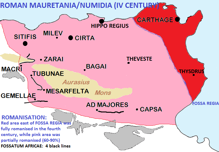
Although Capsa was conquered by the Vandals, it soon became independent and the capital of a newly founded Romano-Berber kingdom in the 6th century (until happened a Byzantine invasion).

Under the Byzantines the city was the capital of the Bizantine province "Byzacena" and enjoyed a period of economic revival. General Solomon build in 540 a new city wall and named the city "Capsa-Justiniana".

When the Arab Oqba Ibn Nafi conquered Capsa in 688 AD he faced fierce resistance from the Berbers, during & after the Arab conquest. It however subsequently lost importance to the Muslim founded Kairouan. Christians living there still were considered Romanized Berbers and continued to speak an "African Latin" as part of their language and remained loyal to the Christian religion.

Capsa is the last place in North Africa where speakers of African Romance could be found "officially" in the thirteenth century, and Christianity was found there for another century, worshiped also in the Roman pools of the old ruins. Christians moved towards Capsa and its surroundings around the 10th century, strengthening its position.

In 1135 to 1155 the Normans conquered Capsa and protected the Christians there for a few years until the Muslim Almohads reconquered the city. Ibn Khaldun hinted at a native Christian community in 14th century in the villages of Nefzaoua, south-west of Tozeur and not far from Capsa. These paid the "Jizuah" and had some people of Sardinian descent among them.

After 1170 the remaining North African churches began to decline and disappear. This was a slow process, and popes continued to appoint bishops to sees like Carthage and Tripoli until the middle of the thirteenth century, but traces of organised, indigenous Christian communities become rare after that time.

Additionally we must pinpoint that the presence of Berber Christians in Libia's Tripolitania is attested at least until the late eleventh century and in the Jebel mountains for another century(https://books.google.com/books?id=pIkmvKB8OlsC&pg=PA121&lpg=PA121&dq=christians+of+Gef%C3%A0ra&source=bl&ots=wq6i_ZLi8O&sig=hdNYBH-szy0dBcioINSxoJwYl_k&hl=en&sa=X&ei=EwyFU4bLO9GEqga474LYAw&ved=0CCkQ6AEwAA#v=onepage&q=christians%20of%20Gef%C3%A0ra&f=false): in the necropolis of En-Gila to the south of Tripoli, a dozen Latin texts dating between 945 and 1003 were discovered (https://www.cairn-int.info/article-E_RHR_2293_0325--byzantine-churches-converted-to-islam.htm#re66no66).

In the second half of the fifteenth century, the Roman humanist Paolo Pompilio noted that the territory of Gafsa was populated by a land of small villages in which the inhabitants spoke a "Latinity" language. Berber Christians continued to live there until the 15th century, while they didn't recognize the new Catholicism of the Renaissance Roman Papacy. This would perhaps deny them support from other Christian powers. A letter in Catholic Church archives from the 14th century shows that there were still four bishoprics left in North Africa (http://www.orthodoxengland.org.uk/maghreb.htm): it was a sharp decline from the over four hundred bishoprics in existence at the time of the Arab conquest!

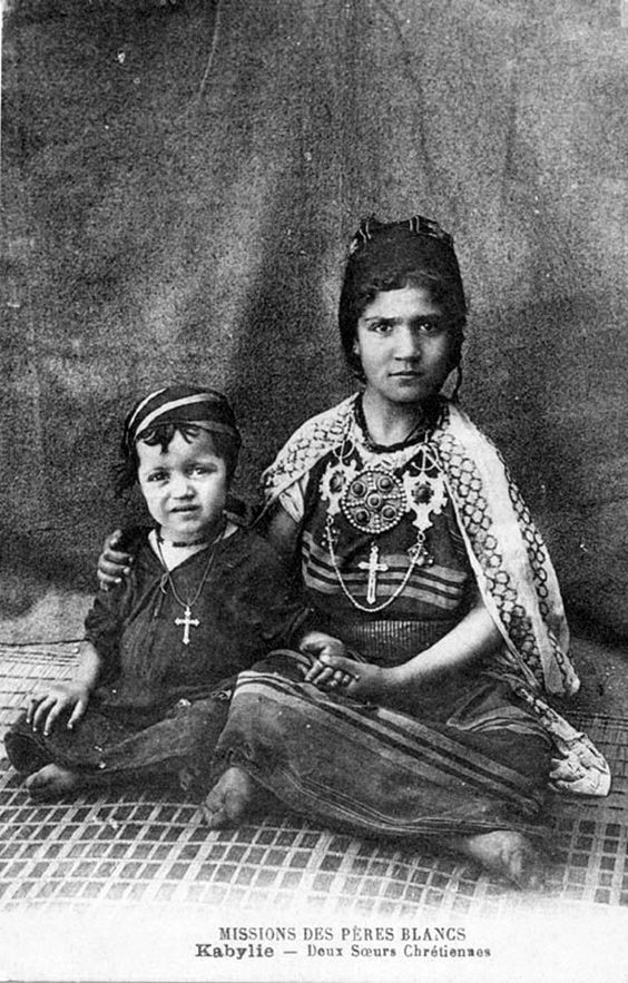
French photo of two young Christian Berbers of the Algeria's Kabylia in the XIX century

The Berber Christians of Roman Mauretania's Septem (actual spanish Ceuta) seem to have been assimilated into the Christianity of nearby Spain. Septem was another pocket of Christianity left over from the Roman period, at least until the X century. Then, in the 1400s Spain conquered the city and Christianity returned to be worshipped in Ceuta, but it was Catholicism linked to Madrid.

In the first quarter of the fifteenth century, the native Christians of Tunis, even though they were heavily assimilated into Islam in various aspects, extended their church, as the last Christians from all over the Maghreb were gathered there. This is the last reference to native Christianity in North-West Africa; Tunis and Capsa seemed to be the last Christian citadels for over fourteen hundred years of continuous Christianity.

Several families of the old African Christian Church were found in Tunis when the spanish emperor Charles V landed there in 1535. Leo the African described the remaining autochtonous Christians in Tunis with these words:
"In the suburb near the gate of El-Manera is a particular street, which is like another little suburb, in which dwell the 'Christians of Tunis'. They are employed as the guard of the Sultan and on some other special duties"
.
The "Christians of Tunis" survived until 1583, when the Turks conquered the city and ordered the extintion of the local christianity. Native romanized Christianity was assimilated into Islam, and it died out forever all over the Maghreb.

For the following centuries, until the XIX century and the arrival of the French in the arabised Maghreb, practically no Christianity was worshipped in this northwestern-african region. But -of course- the spanish Ceuta and Melilla were the exception (as happened even with Algeria's Oran until 1792, when the city was given by Spain to the Algerian Turks/Arabs).

Wednesday, November 4, 2020

SPRING/SUMMER 1941:WHEN THE ITALIANS WERE WELCOMED IN SOUTHERN SLOVENIA

Many forget that the Italian troops were welcomed even with enthusiasm in some territories of Yugoslavia, when Italy (together with Germany) defeated Yugoslavia in April 1941. Unfortunately this "special idyll" between Italians and Slavic populations did not last long, beginning to deteriorate after the Axis attack on Stalin's Soviet Union in June 1941.

Obviously it should be noted that the followers of the Yugoslav king Peter II were almost the only ones who "really" fought against the Italian troops, even if only in Montenegro there was a serious and strong opposition. General Roatta reported in his 'Memories' that "all available forces in northern Italy gathered at the Yugoslav frontier between Tarvisio and Fiume in early March 1941: two armies on the front line, and a third in reserve. Altogether there were thirty-seven divisions, eighty-five groups of medium-caliber artillery, and all the special formations, with corresponding services and supplies".

Representatives of Slovene political parties with the Italian High Commissioner Emilio Grazioli (with military dress) on May 3, 1941. The first to Grazioli's right is Marko Zlatacen
General Ambrosio's troops broke through the yugoslav lines of defense with relative ease in Zara and Venezia Giulia and in a couple of days they arrived in Lubiana and Spalato in what was propagandistically called the "Italian blitzkrieg", making many prisoners of war while were also welcomed by many Croats who greeted them because they wanted independence from the Serbs.

Equally favorable were the Albanian populations in the southern Yugoslavia territories that were conquered by the Italians and which were subsequently united to the "Italian Albania". And almost the same happened in Montenegro and southern Slovenia, at least initially.

But it was the Serbs of northern coastal Yugoslavia who most "liked" the Italian presence in those lands, especially after the surrender of the Yugoslav kingdom and the rise to power of the immediately created "independent state of Croatia" ('Nezavisna Država Hrvatska', abbreviated in NDH) of Ante Pavelic's "Ustascia". In fact the fascist Pavelic, who came to power after 10 April with the declared support of Mussolini (who had helped him for many years: read for more information my 2015 paper, translating it from Italian language http://brunodam.blog.kataweb.it/2015/06/01/quando-la-croazia-sembrava-poter-essere-italiana/), had arrived in Zagreb early in the morning of April 15, leading a few hundred followers dressed in Italian uniforms to become the "Poglavnik" (the Croatian equivalent of "Duce"). Its first "Legal Ordinance for the Defense of the People and the State", dated April 17, 1941, prescribed the death penalty for the breaking of the honor and vital interests of the Croatian people and the survival of the Independent State of Croatia ": it was a clear omen of what would happen in his territories.

Indeed, the Ustascia immediately began to conduct a deliberate campaign of massacres, deportations and forced religious conversions in an attempt to remove the unwanted from their territory: Serbs, Jews, Gypsies, Croatian dissidents and others. The atrocities against non-Croats began on April 27, 1941, when a new unit of the Ustascia army massacred the Serbian community of Gudovac, near Bjelovar. Some days later another massacre happened at Kosinj, in the Lika region. When the Italians knew of these massacres, they strongly rejected what has been done: it was the first 'fracture' between Mussolini and Pavelic

More than a month after the creation of the NDH, the anti-fascist movement emerged in 1941 occupied Yugoslavia mainly under the command of the Communist Party, led by Josip Broz Tito. Slovenian and Croatian partisans (partizans) began what would be recognized as the 'War of Yugoslav Liberation' on June 22, 1941 (shortly after the German attack on the Stalin's Soviet Union), when their first armed unit was formed in Brezovica, near Sisak. The partisans engaged in combat for the first time on June 27 in the Lika region.

Postcard of Lubiana under Italian control in summer 1941
But in Slovenia for more than 3 months - after the defeat of Yugoslavia in April 15 and until the end of July - there was a "relatively quiet" peace without anti-Italian resistance, initially supported by the Slovenes who today are generically called "Domobranci" (Slovenian anti-communists). In August and September there were some sabotages, but only on October 1941 there was the first military action of Italian troops against the Slovenian resistance, when two Tito partizans were killed

At the same time in southern Slovenia nearly 20,000 Slovenians collaborated with the Italians (as members of anticommunist organizations, from "Civic Guards" to "BelaGardists").

The welcome to the Italians

As we all know, Yugoslavia was divided between areas of influence/occupation "(that of Italy, Germany, Bulgaria and Hungary). The Italian presence took place in four regions of its area, populated mainly by: Slovenes, Croats, Montenegrins and Albanians. The Slovenian one was special, because the "Provincia di Lubiana" was created as an attempt to assimilate/integrate this area into Fascist Italy.

Emilio Grazioli was made by Mussolini the main Italian authority in Lubiana: his nomination was welcomed by many slovenian leaders, from Marko Natlacen (the last Governor of the Yugoslavia's "Drava Banovina") and Juro Adlesic (mayor of Lubiana) to Leon Putnik (general & anti-communist politician) and Gregory Rozman (bishop of Lubiana).

Lubiana, April/22/1941. From left: Ignacij Nadrah,Emilio Grazioli,Gregorij Rožman,Frank Kimovec


Furthermore, it is noteworthy to pinpoint that some slovenians were grateful to the Italians because of the 1941/1942 removal of the German speaking population of the so called "Gottschee" in the southernmost area of Slovenia: it was the same kind of agreement between Mussolini and Hitler that was done for the Germans in Italy's Alto Adige. Since then the Gottschee area has been a fully Slovene territory.

SLOVENIA ITALIANA

The southern part of Slovenia which was occupied by the Italians was annexed to the Kingdom of Italy on May 3, 1941, with the official name: "Provincia italiana di Lubiana" ('Italian province of Ljubljana') with 4545 km2 and 337,000 inhabitants (nearly 80,000 in Lubiana). This province, which took its name from the capital Lubiana (the Roman "Emona"), was in fact partially administered as an occupation zone. However there were no real attempts at Italianization (there were only 600 Italian civilians in all the 'Provincia'!), neither by the public administration (in which only some personnel from the mother-country were included) nor by the school (bilingualism was allowed) and cultural institutions (maintained and only in some cases accompanied by the fascist ones).

In addition, works were started by the Italian authorities in order to improve health services, public structures, electricity services and sewage systems in Lubiana & surroundings. A new huge & modern hospital was planned. Also, the railway service between Italian Slovenia and Trieste was improved; and the Polje airport in western Lubiana was greatly enlarged.

The Lubiana airport was greatly improved by the Italians. It was one of the easternmost airports in the "Seconda Squadra" (second division) of the Italian Air Force during WW2
The high commissioner Emilio Grazioli initially carried out a moderate policy, in an attempt to involve the conservative business classes and the Catholic Church, giving life to a "Consulta", an assembly of local notables that was supposed to cooperate and support the work of the italian authorities. Indeed, the influential bishop of Lubiana, Gregorij Rožman, and most of the country's pre-war politicians, led by political leader Marko Natlačen, immediately expressed in early May 1941 their willingness to collaborate with the fascist authorities, writing public letters of support for the annexation of the province of Lubliana to Italy. On June 8, 1941, Natlačen led Slovenian politicians and industrialists to meet Mussolini in Rome, after which they reaffirmed their loyalty, and began to officially collaborate with the Italians in the 'Consulta', an advisory body.

In the days immediately following, 105 Slovenian mayors sent a message to Mussolini, expressing "joy and pride for the incorporation of Slovenian territories into the great Kingdom of Italy". A similar message of congratulations also reached the Duce from the archbishop of Lubiana, Gregorij Rozman. This catholic "vescovo" (with Ignacj Nadrah and Frank Kimovec) became one of the most important collaborators of the fascist regime, guaranteeing the loyalty of large sections of the 'believing' catholic population.

Lubiana: Military parade of Italians on first week of April 1941, with slovenian civilians attending


The result of German harsh policy in the nazi occupied area north of Lubliana was the influx of tens of thousands of Slovenes into the Italian province. A few weeks after the end of the war against Yugoslavia, 27,000 people crossed the border between German and Italian Slovenia (17,000 settled in Lubiana). The Italian reports on these facts left no room for doubt about the causes of the exodus, identified in the German "inhuman yoke". Germany was accused of stripping Slovenian land and stripping the local population of the basis for their survival. In doing so, Berlin forced the population to seek a less "barbaric" place for its existence. And even in the final months of 1941 hundreds of Slovenians crossed the border between the two occupation zones to settle in the Italian territory. This created problems (of food, lodging, health assistance, etc..) to the Italian authorities, but showed to the Slovenians the "good side" of Italian presence in southern Slovenia.

However this continuous influx of people from the north was viewed with suspicion -after summer 1941- by the Italian administration, which feared that once they arrived, especially men, they could become a threat to the internal security of the province (because linked to Tito's partizans): according to general Roatta they were the main culprit of the guerrilla & terrorism attacks that destroyed the good relationships between Italians and Slovenians at the end of 1941/beginning of 1942 (M. Roatta, "Otto milioni di Baionette. L’esercito italiano in guerra dal 1940 al 1944". Mondadori. Milano, 1946).

Some historians pinpoint that the original population of Lubiana & southern Slovenia was going to behave in a relatively "quiet way" with the Italians, like happened in the Governorate of Dalmatia at least untl the end of 1942: it was people from northern Slovenia (and other areas of Iugoslavia) who enrolled in Tito's partizan groups and who created the fracture between Italians and local Slovenians, mainly after fall 1941!

Although very few, Slovenian fascists had made themselves known in Slovenian politics since the 1920s: in 1923 a small fascist party of Slovenes of Venezia Giulia ("Vladna Stranka", government party) was born, which then in 1925 merged into the 'Party National Fascist', and a certain amount of unemployed Slovenian youth joined the Fascist militia. In Lubiana in May 1941, immediately small groups of Slovenian fascists were created who obviously supported the union with the Kingdom of Italy (but only on 21 October 1941 the National Secretariat of the National Fascist Party established - on Mussolini's orders - the "Federation of Fascists of Combat of Lubiana ": Grazioli was appointed Federal Secretary).

After all, some Slovenes (fascists and non-fascists) immediately promoted the establishment of collaborationist armed bands, subsequently called MVAC (Voluntary Anti-Communist Militia) and integrated into small units in the Italian army. The MVAC had a decidedly notable importance in Slovenia, where some old adherents of the conservative pre-war parties, tightened around the highest ecclesiastical hierarchies and animated by a heated anti-communism, created a political-military structure that obtained a wide consensus and came to mobilize more than 6,100 men in 1941 and 1942. In fact, the Italian authorities immediately supported the anti-communist Slovenian political forces, especially of Catholic inspiration, which, fearing the communist revolution, had at that moment identified the greatest danger in the partisan communist movement, and had therefore made themselves available for collaboration.

These political forces had thus created "self-defense formations" (the most numerous "Vaška Straža" and the most militant "Legija Smrti" or 'Legion of Death' - the latter also called more commonly 'White Guard' or "Bela Garda"- under the direct inspiration and coordination of the Bishop of Lubiana Gregorij Rožman: the Italian commands (under General Mario Roatta of the 2nd Italian Army) organized these formations, in the following August 1942, in the" Anti Communist Voluntary Militia" or MVAC (new name collective hired by the pre-existing Slovenian organizations from 6 August 1942), using them successfully in the anti-partisan struggle.

Also worth mentioning is the "Civic Guard" ('Vaške Straže' or village guards), which was created in November 1941 by Ernst Peterlin. It was a militia of Slovenian Catholic peasants set up to prevent the robberies and assaults of the "Tito" communist partisans in the Slovenian countryside. The Civic Guard was also created (in the intentions of its leaders) to prevent the establishment of communist political and military power on Slovenian territory, with the ultimate aim of contributing to the establishment of a Catholic political system in the country.

The 'Civic Guard' (with dark berrets) of Rakitna -a village between Lubiana and Postumia- with Italian officers and some civilians & religious groups, in summer 1941
It should be noted that in addition to the approximately 6,100 of the MVAC, the Slovenian Catholic auxiliary forces deployed a total of 7,000 men alongside the Italian authorities at the end of 1941, when the communist resistance in Slovenia began to be present in a serious form (with attacks and murders): the idyll in Slovenia was over!

Furthermore, in December 1941 an Italian teacher was killed by the Slovenian Communists in front of her pupils in Lubiana (read for further informationhttps://books.google.com/books?id=SGCuAgAAQBAJ&pg=PA49&lpg=PA49&dq=uccisione+di+maestra+italiana+a+lubiana+nel+1941&source=bl&ots=ygJ_DFeepV&sig=ACfU3U3Yj0uJ0xTobF-TUmYVwjonIXFQew&hl=en&sa=X&ved=2ahUKEwjanuau8-LsAhWuxFkKHSo7DDIQ6AEwEnoECAEQAg#v=onepage&q=uccisione%20di%20maestra%20italiana%20a%20lubiana%20nel%201941&f=false). She was the first Italian civilian (and the first Italian woman) assassinated by the Tito partizans in Slovenia, sparking the reaction of the Italian military authorities (who consequently -also because of this murder- enclosed with a barbed wire fence all the city of Lubiana in January 1942).

In other words, this "special idyll" had been quite successful and even happy in the months of May and June 1941, but with the Axis attack against Stalin's Soviet Union it began to disintegrate and by early 1942 it had completely vanished: it didn't even last one year!
Map of 1942, showing the new northeastern borders of the kingdom of Italy.

Saturday, October 3, 2020

ROMANS IN THE AZORES ISLANDS?

Romans -as we know- travelled outside the Mediterranean sea reaching in the Atlantic ocean the British isles to the north and the Canary islands to the south. Probably they were merchants, like in the commerce between Rome and India described with the famous "Periplus of the Erythraean sea" (if interested in further information, please read what I wrote in 2015 at https://researchomnia.blogspot.com/2015/10/romans-in-azaniaraphta.html ).

However we don't know for sure if they reached the Azores islands in the middle of the northern Atlantic ocean. But now some researchers have found a few archaeological evidences about this possibility. One of the most interesting is the one related to an epigraph -in latin letters- found in the Terceira island of the Azores. Here it is what I found in my research:

Map of the Azores, showing "Terceira" island (where a possible Roman epigraph has been found)
The president of the Portuguese Association of Archaeological Research (APIA), Nuno Ribeiro, revealed in 2019 having found rock art on the island of Terceira in the Azores, supporting his believe that human occupation of the Azores predates the arrival of the Portuguese by many thousands of years. “We have found a rock art site with representations we believe can be dated back to the Bronze Age,” Ribeiro told at a presentation in "University of the Azores" on the topic of early human occupation of the Azores. The oldest cave art known in Europe is of prehistoric origin, dating back to approximately 40,000 years ago.

In the last three years, Ribeiro has been claiming that archaeological remains of structures discovered on several Azorean islands are of pre-Portuguese origin by its architecture and construction. “WE HAVE AN EPIGRAPH FROM ROMAN TIMES, according to two scientists who were invited to interpret the inscription, a cave art site, megalithic structures, and an important set of structures scattered throughout the islands that need to be interpreted in new ways,” he said. “In some cases, we believe that there are temples and hypogea. We have no doubt that there are sanctuaries,” he said, remarking that some data still needs to be dated. Ribeiro also said that the archaeological research findings in the Azores have been published in scientific articles and presented at international conferences on archaeology, and have received “great acceptance among the international scientific community.”

Nuno Ribeiro (with Anabela Joaquinito & Antonio Pereira) wrote the following essay with the title "New Unknown Archaeological Data in Azores: The Hipogea of the Brazil Mount, Terceira Island (Azores, Portugal) and its Parallels with the Cultures of the Mediterranean"

".....The presentation intends to give to know the recent discoveries of found hypogeal structures in the Island of Terceira (Açores), Mount Brazil. The monuments in question are placed in an area next to where in August of 2010 it was discovered the 1º hypogeum. These new monuments present trapezoidal plants, with circular entrances, one of them present four small circular sockets in its interior, being on for channels, another one present a tank probably ceremonial, which if accedes through stairs. The existence of murex in the region and the fact of this island to make use of the best natural ports of the Atlantic islands and if to point out enters the North of Africa and the Europe, had apparently made of this area an obligator point of stopping between the Canaries, the colonies of Lixus and Mogador (in coastal Roman Mauretania) and Europe......

.....Of the various kinds of similar monuments present on the different Azores islands, most prominent are the Hypogeum-like ones, especially from Terceira Island, on a military restricted area, and actually classified as being of World Heritage status by UNESCO. This area, called Mount Brazil, bears several nuclei, the most important one being at the Fort of São Diogo. More structures are present in this open-air area, on one of the highest peaks of the Mount Brazil, “one called the Pico do Facho”, located near historical structures. The ancient remains are characterized by the presence of dozens of postholes of various dimensions, small canals, basins, possible chairs excavated from the outcrop and by at least one reservoir (figure 2 and 3). They might form a proto-historic sanctuary. This assemblage was discovered by the prehistorian Manuel Calado during a visit organized by APIA in December 2010......

....The artificial caves or hypogea (identified with an arrow) are situated on the western slope of the Zimbreiro Peak and just above the sea, at the border between the woody part of the slope and the severely eroded area.Our interpretation, at the moment is based on the architecture of the existing monuments only, and awaiting archaeological excavations, needs confirmation.

However, a medieval or modern origin of the remains is ruled out, we compared them with what we know about XVth and XVIth century Portuguese and Spanish architecture - the time when the island was supposedly first colonised. We shall also stress that these monuments were already marked on XIXth century maps, but not as military structures.

And present inscription, engraved on what is possibly the base of a statue now in a house in Posto Santo, near the city of Angra on Terceira Island. It was also possible to establish the origin of the material composing the base for the inscription: about 4 Km away from where it is now (Figure 13). The association of these monuments with an inscription of Dacian origin confirms an occupation of the island earlier than what is generally accepted.

The base of a light coloured volcanic rock, trachyte, which is rough on the touch, shaped round as a column and inscribed outside by about 2/3 of the round. The inscribed stone is conserved in a private home, situated in the city of Angra Heroism, Terceira Island already since several decades. The circumstances of the found are not known. The stone base was originally at about 4 km at a place named Posto Santo, where the trachyte rock is present.

According Prof. Herbert Sauren, we can see two lines of script, some letters very well known as Latin (or Greek) majuscules, but others with strange forms and irregular in height (Figure 14). A base for a statue with the given size was an important monument. The lost statue was also very important. We can guess the statue of a governor, of a king, or of a God.

The beginning of the inscription is broken. The letter D at the beginning of the second line marks the limit of the inscription at the left side. The last letters of both lines are preserved. The inscription could be read when the reader stood in front of the statue.

Transliteration, vocalized form, translation:

[OD]ROY ELOFC ION
D A C C I C OFC
Odroy Elo’ǀs ’Ayon / Dacciǀs The’os

Odroy, the Lord of the gods,
the god of the Dacians.

Spanish investigator Antonio Rodriguez Colmenero, (Professor at the Santiago de Compostela University) interprets the epigraph in another way: Converging in Roman times however should not be a base of a statue but a milestone. The scientist also reads other content at the beginning of the text: OPELIO (indeterminate text) and at the end fecit, usually the inscriptions of Emperor usually have: IMP M. OPELIO SEVERE Macrinus, but according to the author that is not text that is in the epigraph...."


If interested, please read the full essay with interesting photos (and with the epigraph's Latin letters shown) at http://www.apia.pt/doc.php?co=118&in=0

Of course there are other researches about this epigraph. If interested read also the following article written by Herbert Sauren and related to similar items & topics:https://www.academia.edu/8132405/Azores_Inscription_on_the_base_of_a_statue

Wednesday, September 2, 2020

ITALIAN PROVINCES IN GREEK REGIONS

The Kingdom of Italy (1861-1947) expanded Italian influence and control on some islands of Greece. In the first half of the XX century there were also a few tentatives to create the following "italian provinces" in those islands: "Provincia di Corfu", "Provincia di Rodi", "Provincia delle Cicladi" and "Provincia delle Sporadi".

Initially these tentatives were due to some ideals linked to the "Italian Irredentism", like as happened with Corfu and the Ionian islands. Those islands (mainly Corfu, actual Kerkyra, please read also http://wwwbisanzioit.blogspot.com/search/label/Corfu) in the beginning of the XIX century had a huge community of venetian speaking inhabitants (the island of Cefalonia -actual Kephalonia- was nearly totally venetian speaking in the XVIII century, according to: Kendrick, Tertius T. C. (1822). "The Ionian islands: Manners and customs"; p. 106 ), as a consequence of the Republic of Venice "dominions" in this region since the Middle Ages. For example one of the Italian "Risorgimento" fathers was Ugo Foscolo, born in Zante (actual Zakynthos).

Festa di San Spiridiano in "Citta di Corfu" (Corfu city) in early summer 1942, showing some of the 2000 Corfiot Italians of the island. The city was proposed to be the capital of a possible 1943 "Provincia di Corfu", but WW2's Italian defeat blocked this project
In Corfu, the "Corfiot Italians" were helped by Mussolini, when he took control of Italy in the 1920s (read, if interested in further information, the article I created in wikipedia and named "Corfiot Italians" or see: https://6612springbottomway.blogspot.com/2018/12/blog-post.html).

Additionally it is noteworhty to pinpoint that the island of Corfu was "administratively" separated from Greece, when was occupied by Italy in spring 1941, while the Corfiot Italians welcomed the Italian troops in those 1941 days: see https://www.youtube.com/watch?v=HCktc3anQo4. There were -also- some comments from the same Mussolini in order to create a "Provincia di Corfu" in late 1942.

Furthermore in 1911 the Italians conquered from Turkey the "Rodi archipelago islands", that they called "Dodecaneso italiano". They added in 1932 to this possession also the island of Castellorizo with the small surrounding little islands, that were the remains of the Italian possessions in Licia (southwestern Anatolia) after WW1

The Dodecanese islands were formally annexed by Fascist Italy, as the "Possedimenti Italiani dell'Egeo" in 1923, following an agreement between Mussolini and Kemal Atatürk. Italian interest in the Dodecanese was rooted in strategic purposes, and the islands were intended to further the Italian Empire's long range imperial policy: the islands of Leros and Patmos were used as bases for the Royal Italian Navy. In the 1930s, Mussolini embarked on a program of Italianization, hoping to make the island of Rhodes a modern transportation hub that would serve as a focal point for the spread of Italian culture in Greece and the Levant.

Dodecaneso Italiano (Rhodes archipelago)
The Fascist program did have some positive effects in its attempts to modernize the islands, resulting in the eradication of malaria, the construction of hospitals, aqueducts, a power plant to provide Rhodes' capital with electric lighting and the establishment of the Dodecanese Cadastre. In 1940 there were nearly 9000 italian colonists in these islands, mainly in Rodi that was greatly improved with monumental buildings in accordance with fascist architecture. Some Italian nationalsts proposed to create a "Provincia italiana di Rodi" in the early 1940, but the start of the war blocked all these projects.

Additionally, during WW2 the Italian authorities proposed to create two provinces in the Aegean sea: the "Provincia delle Cicladi" and the "Provincia di Samo" (named also "Provincia delle Sporadi"). Here it is an interesting article related to this tentative (it was written for the University of Genova by B. D'Ambrosio):

PROVINCIA DELLE CICLADI E PROVINCIA DELLE SPORADI (SAMO)

Few scholars have thoroughly analyzed the Italian occupation of the Sporades and Cyclades islands in the Second World War.

After all the war difficulties, Italy - with the "suffered" victory over Greece - in 1941 obtained control of most of mainland Greece (Epirus, Thessaly, Attica and Peloponnese), in addition to the Ionian islands with Corfu, Zante and Kefalonia, Cyclades, and the southern Sporades with Samos, Furni and Icaria plus a territory at the eastern tip of Crete.

HISTORICAL SITUATION IN 1941-1943

The territorial division of Greece was fundamentally decided by the Germans and communicated to the Italians as a 'fait accompli' ("the Germans communicated a boundary to us, we could not but acknowledge" Mussolini himself recognized), as was the Athens settlement of the Tsolakoglu government.

Italy's plans for the annexation of various Greek territories (the Ionian Islands, the Cyclades and the Sporades to be added to the Dodecanese, the Epirus to be annexed to Albania) were postponed by the Germans themselves at the time of the final victory in the war.

The military occupation of the Greek regions, entrusted to the "XI Armata", represented a heavy commitment for Italy in terms of men and resources employed, even if very uneven in terms of the armed opposition encountered: the Greek Resistance was active in the northern regions, Epirus and Thessaly, while in the Peloponnese and in the islands it was never particularly strong, leaving to the Italian units there more police-related tasks than violent repression.

However, in spite of the hostility shown at the time of surrender in April 1941, with the passage of time the attitude of the Greek population became more benevolent towards the Italians, whose behavior in principle had little to do with the methods of violent occupation of the Germans. After all, it is enough to see a famous film about the Italian occupation of Kefalonia - "The mandolin of Captain Corelli" - to understand how the Greek populations showed themselves "benevolent" towards the Italian occupants (and vice versa).

CYCLADES AND ITALIAN SPORADES: "PROVINCE OF THE CYCLADES" AND "PROVINCE OF SAMO"

The irredentism of Fascism wanted to include in its project of enlargement of imperial Italy - going back to the maritime republics of Venice and Genoa - even the islands of the Aegean between the Dodecanese and the Ionian islands. In this way Mussolini wanted to create (after his victory in WW2, as he hoped) a historical-geographical continuity of Italian islands that from Corfu '(in front of Albania) arrived until Castellorizzo (in front of southern Anatolia).

For this purpose - after the occupation of almost all of Greece in April 1941 - the Italian authorities proceeded to implement a forced "Italianization" of the local populations of these Greek islands together with the administrative creation of "Italian Provinces" (such as the Ionian provinces, p[us the Cyclades and Samo provinces).

For Corfu' Mussolini went back to the "Italian Corfioti", immediately detaching the Ionian islands from Greece (at least administratively), while for the Aegean islands he limited himself to wait until the end of the war in order of not going against the will of Hitler.

The Cyclades islands and some of the Sporades islands were militarily occupied in the spring of 1941 and were immediately incorporated into the "Italian islands of the Aegean". Ettore Bastico had the title of "Civil and Military Governor" of the Italian Isles of the Aegean, just like the previous governor of the "Islands of the Dodecanese" Cesare Maria De Vecchi of Val Cismon.

ETTORE BASTICO was governor from 10/12/1940 to 1/7/1941. Admiral Inigo Campioni, later shot by the Germans, succeeded him from 15/7/1941 to 11/9/1943. Consul General Igino Ugo Faralli was its last governor, from 11/9/1943 to 18/9/1943. Indeed Ettore Bastico was an artillery general. Thanks to his noble conduct, he earned the esteem and affection of the civilians and the military in the Italian Aegean islands, taking measures to improve their lives. He occupied Castellorizzo, the Cyclades, Samos and Icaria as well as the east part of Crete. He was suddenly transferred, perhaps as a reward, to the African front (Fanizza Rugerro: "De Vecchi, Bastico, Campioni, the last governors of the Aegean." Vasbonesi, Forlì, 1947).

INIGO CAMPIONI followed Bastico. He tried to impose a process of "Italianization" in these islands, but with only minor results.

ITALIAN CYCLADES

CYCLADES: The Cyclades were administered as a future "Italian province": the "CIVIL COMMISSIONER FOR THE PROVINCE OF CYCLADES" was established on the island of Syra (also called "Siro" in Italian). Ermopoli, the administrative capital of the Cyclades islands, was and is the capital of the island. In Siro, the Italian authorities created a police station that promoted - among other things - food aid to the civilian populations of the Cyclades: in this way the terrible famine that hit the Greek population in 1942 did only a few thousand victims in the Cyclades (and were relatively few in all the other Greek islands that, in Mussolini's projects, should have been annexed to Italy at the end of the "victorious" world war). Only a few minor islands suffered a great deal initially - but they were immediately rescued by the Italian government, unlike the huge disaster (with many deaths: over 300,000 between 1941 and 1944!) that occurred in the Greek mainland. If interested, read on page 144-149 the book "Famine and Death in Occupied Greece, 1941-1944", written by Violetta Hionidou

The Italian occupation began on the islands in the Aegean on May 6, 1941. The island of Siro, with the capital of the Cyclades, was occupied after only five days. The invasion force was formed by units of the "Regina" Division, which were transported by destroyers Crispi and Sella (departing from the nearby Dodecanese). The following 10 July 1941 took over the "Cuneo" Division to the "Queen" units in the southern Cyclades and Sporades garrison. An air link between Rhodes and Siro guaranteed the postal service. In Italian Cycladic schools the study of the Italian language became compulsory.

Among the civilian population there was a substantial approval of the Italian presence only in the area of ​​the capital of Siro and in the island of Tino, where many boasted distant Venetian roots and were numerous Catholics for centuries - especially in the town "Ano Syros", founded in 1200 by the Venetians. Ano Syros, the Catholic stronghold in Siro, supported the Italianization of the Cyclades even if moderately: this was assisted by the Italian authorities and did not suffer death from the famine that damaged the Greek population especially in February 1942. Many Catholic inhabitants of Ano Syros (and someone from Tino) were later imprisoned by the Greeks (Orthodox) with the charge of collaborationism in 1945.

ITALIAN SPORADES

SPORADES: The same happened with the southern Sporades islands occupied by the Italians. In fact the three main islands of the Italian Sporades (Samo, Icaria and Fourni) were administered with the creation of the "CIVIL COMMISSIONER FOR THE PROVINCE OF SAMO". Also in this case it was expected that at the conclusion of the war these islands were to unite to the Kingdom of Italy in the newly created "Province of Samo".

On May 9, 1941 the island of Samo, the main island of the southern Italian Sporades, was occupied by the "Regina" Division and Vathy (near the historic town of Samo) declared its administrative capital. In the following September, the "Cuneo" Division took over the "Regina". In Samo a first telegraph service was set up in September 1941. A forced attempt at Italianisation was also begun here, especially in schools.

The attempt by the wife of the political commissioner Bianco Tizianotti to organize social events in Samo and Icaria, failed miserably. The antipathy of the population was such that very few local Greeks (less than a hundred in all) were accused of collaboration after the end of the war (in 1945).

At Samos from the end of 1942 there was a reduced action of Greek partisans against the Italian troops, unlike the other Cycladic islands and Sporades where until September 1943 - when Italy surrendered to the Allies - there was no military or paramilitary activity.

In fact, at the time of the Badoglio armistice, in September 1943, on the island of Samos, there were two groups of resistants of about 300 men. These groups, which politically were of the extreme left, had been organized in October 1942. The ELAS (Greek Resistance Army) of Samos received the armament and financial help of the British service SOE, located in Asia Minor, with whom it had been in permanent contact since the end of 1942.

The essential contribution of this resistance was the harassment of the Italian authorities and the main purpose was a general uprising. The plan failed because the anti-fascist committee, waiting for the maneuvers of Badoglio who took over from Mussolini, did not dare to move openly. Restless, the Italian authorities of Rhodes sent two battalions of Italian fascist 'Black Shirts' to observe the possible maneuvers of these resisters.... and all remained quiet (Nicola Tsagas: "Icaria under the Italian occupation, 1941 - 1943").

Map of the theoretical provinces of Italy in Greece's Aegean sea:

PROVINCIA DELLE CICLADI
PROVINCIA DI SAMO (SPORADI)

Tuesday, August 4, 2020

AROMANIANS IN MACEDONIA'S FIGHT FOR INDEPENDENCE (ILINDEN UPRISING)

Many books have been written about the "Ilinden Uprising" and Macedonia's independence, but only a few study in detail the Aromanians and their interaction with Macedonian organizations.

First of all we must remember that during the summer 1903 rebellion in the region of Macedonia most of the central and southwestern parts of the Ottoman "Monastir Vilayet" were devastated by the Ottoman forces. These Turks attacked the independence fighters, who were receiving the support of the local Slav peasants with a huge help from the Aromanians (called also "Vlachs") living in the region. Provisional government was established in the town of Krusevo, where the insurgents proclaimed the "Krusevo Republic" which was overrun in a bloody way after just ten days, on August 12.

Indeed in March 1903, the Aromanian Pitu Gulli began commanding a revolutionary squad, crossing the Bulgarian-Ottoman border heading for Krusevo. From April to August 1903, he trained and prepared his irregulars for the upcoming Ilinden Uprising. He died in Kruševo, defending the Krusevo Republic with his nearly 1000 Aromanian fighters.

Many of the independence fighters in Krusevo were Aromanians: according to the ethnographer Vasil Kanchov's statistics based on linguistic affinity, at that time the town's inhabitants counted: 4,950 Slavs, more than 4,000 Vlachs (Aromanians) and 400 Orthodox Albanians.

The "prime minister" of the Krusevo republic was the Aromanian Vangel Dunu.  

Mečkin Kamen (where today there it is a commemorative monument) was the place where Pitu Guli's fighters (most of them Aromanians) defended the town of Kruševo from the Turkish troops coming from Bitola. Nearly the whole squad and their leader perished during the battle. And Kruševo as well as many of the nearby villages were set to fire by the Ottomans.

However, following the revolt, Romania, with the support of Austria-Hungary and Italy, succeeded in the acceptance of Vlachs as a separate millet with the decree ("irade" in turkish) of May 22, 1905 by Sultan Abdulhamid; so in the "Ullah millet" (the millet of the Vlachs, the first "proto-state" of the Aromanians in their History) they could have their own churches and schools.

Photo showing the 2011 celebration of the "Krusevo Republic". Note the monument to the Ilinden Uprising of summer 1903.


In the following decades the Aromanian population in Krusevo has been reduced because of many reasons, but in 2020 there are -still- more than 1200 Aromanians in this macedonian city of nearly 6000 inhabitants.

An interesting essay has been written by Nikola Minov about the Aromanians and Macedonia's independence. Here it is a resumen (with excerpts from the "Macedonian Historical Review"):


THE AROMANIANS AND THE IMRO


The Macedonian revolutionary national-liberation movement, organized and led by the Internal Macedonian Revolutionary Organization (IMRO) has long provoked the interest of contemporaries and scholars of the modern Macedonian history. The interest shown by the numerous diplomats, historians, journalists and analysts has produced an enormous historiographic work which examines IMRO and the Macedonian revolutionary movement from every aspect. 

However, the origins, acts and goals of IMRO can naturally be viewed differently, taking into account each author’s provenance and the time at which the work was published. 


The same can be said for the Aromanian participation in the revolutionary organization. 

While historians in the Republic of Macedonia and Bulgaria acknowledge the Aromanian contribution within IMRO, the two sides who have traditionally invested the most interest in the Aromanian question – Romania and Greece – have preferred either to ignore the Macedo-Aromanian collaboration, or to present the Aromanian involvement in the Organization as “forced collaboration”, under pressure from the “Bulgarian bandits”. 

This stance has its roots in Romania and Greece’s Macedonian policy from the end of the 19th and the beginning of the 20th century. The Romanian propagandistic presence in Macedonia focuses on the Aromanian population, presenting them as being part of the Romanian nation. On the one side, the future existence of this propaganda in Macedonia required the Aromanians – seen as Romania’s pawn on the Balkan chess table – to remain faithful subjects of the Sultan. On the other side, Bucharest did not want to see (or simply could not see) IMRO’s indigenousness, and no matter how much IMRO kept proving its independence from the Bulgarian cabinet, Romanians considered the Macedonian revolutionary movement to be spurious, fostered by Sofia, and in it the Romanian politicians saw nothing else but an extended arm of Bulgaria’s expansionistic policy. 

For this reason Aromanian participation in IMRO complicated Romania’s position, not only for the fear that Bulgaria would steal Bucharest’s main trump card in its Macedonian policy, but also due to the realistic danger of disturbing amicable relations with the Ottoman Empire. 

The Greek Kingdom also had important plans with the Latin speaking people north of its border, and for this it gave the Aromanians a vital role in the Great Idea’s fulfillment. Greece had little to worry about while the various nationalities in the Ottoman Empire were under the jurisdiction of the Ecumenical Patriarchate of Constantinople, but when the Slavic population of Macedonia joined the Exarchate en masse, the number of “Greeks” in Macedonia started its uncontrollable decrease. 

Were the Aromanians to follow the same example, then it is likely that Hellenism would have to completely vanish from a number of cities in Macedonia, whose presence was principally represented by the Aromanian population. If the Aromanians were shown to be Greeks, then Greece could claim to have citizens north in Bitola and Krushevo. If, on the other hand, the Aromanians were not considered to be Greeks, then Greece’s claims in Macedonia were seriously threatened, with only a negligible minority living more than 100 kilometers north of its border. Hellenism would be forced to retreat south of the river Bistritsa (Haliacmon) and the Greeks would cut a poor figure among the statistics of the Macedonian races. The Aromanians were Greece’s predetermined prize and Athens could not let them fall in the hands of its arch enemy in Macedonia, the Bulgarians. 

This line of thinking was the main reason for the numerous statements given by Romanian and Greek diplomats, distributed to the public in both countries through pro-governmental media, in which they deny the Aromanian involvement in IMRO and the Ilinden Uprising. Whenever the Aromanian presence in the revolutionary bands was confirmed by the Ottoman authorities, Bucharest and Athens found a convenient excuse, claiming that the Aromanians were subjects of atrocities committed by the “Bulgarian bands” and that they were forced to join IMRO. This is the reason for which the Greek consul in Bitola, Kypreos, claims that the Aromanian settlements were under strong pressure from the


Photo of the squad of aromanian leader Pitu Guli near Birino, in 1903


The pro - governmental media in the Romanian capital came out with similar statements that “the Romanians from Macedonia did not take part in the Bulgarian revolutionary movement, nor did they sympathize with it, and when they did take part, they were doing so because they were forced by the Bulgarian bands” . It was claimed that “The Romanians endure the consequences from the bitter war between the bands of the committees and the Turkish army. The Romanian settlements are occupied due to strategical or other motives and forced to… give youngsters to the bands”. Certain Romanian newspapers were informing the public how those killed in the Ilinden Uprising in Krushevo were mostly “Romanians who became victims of a battle with which they have nothing in common, while the insurgents were described as pseudo-liberators and “Bulgarian bands who killed most of the Romanians who refused to support the rebellion”. 

Not many were willing to deny the claims coming from the political circles in Athens and Bucharest, with certain notable exceptions. Those who were most informed about the Aromanian involvement in the Organization and in the Ilinden uprising, i.e the leaders and the members of IMRO, preferred not to talk about it in order to protect the Aromanian villages from the regular Ottoman army and the bashi - bazouks. In the few historical studies that deal with the Aromanian presence in IMRO, it is indicated that the main reason which attracted the Aromanians to join the Organization were “the terrible cruelties and injustices committed over them by the Ottoman authorities”. This claim is correct in principle, but it is too simplified and only partially explains why the Aromanians showed solidarity with the Macedonian revolutionaries. 

The rationale behind why one part of the Aromanian population accepted IMRO, one part showed indifference and the third part refused any sort of cooperation, therefore openly showing its animosity towards the Organization, is much more complex and requires more space for analysis. We do not aspire to write a complete analysis of the Aromanian involvement and influence in IMRO, so we will limit the inquiry to the reasons which resulted in a part of the Aromanian population joining the Macedonian Revolutionary Organization. 

A large number of Aromanian and Megleno-Vlach villages did indeed feel the weight of the Ottoman yoke. The terror inflicted by the Ottomans and the nearby Islamized village of Nonte was felt the most by the Megleno-Vlachs. When the German linguist Gustav Weigand visited Meglen in 1890, the first thing he noticed was the horrible poverty, atypical for the Aromanian villages he had previously visited. The village of Birislav was a chiflik of Nonte and the villagers were regularly terrorized by their masters and by the soldiers. Oshin, Luguntsi and Huma were properties belonging to Turks and Jews from Salonica, while the Aromanian village of Livadi was chiflik of Turkish beys from Yannitsa. Most of the other MeglenoVlach villages were also chifliks.  

Relatively isolated and yet situated in an excellent strategic position near the main road that led to Salonica, under strong influence from their Slavic neighbors and with little to no Greek influence among them, the Megleno-Vlach villages quickly attracted the attention of IMRO’s leaders. The first article of IMRO’s constitution from 1897, which allowed all unsatisfied element of the population in Macedonia and Odrin to be included in the Organization regardless of ethnicity, widely opened IMRO’s doors for the non-Slavic population in Meglen. Argir Manasiev and Vasil Chekalarov set up the organizational foundation in Barovitsa and in 1897 the same two visited many villages on Mount Pajak (Paiko) after which IMRO’s ideas finally reached the Megleno-Vlachs. Manasiev’s tremendous organizational qualities soon bore their fruit. According to one of IMRO’s leaders in the Gevgeli region, Sava Mihajlov, all the Vlach villages in the Gevgeli area were faithful to the Organization. The number of IMRO band leaders (voivods), corporals and normal band members emerging from the villages in Vlacho-Meglen was impressive. The huts of the Aromanian nomads from Livadi and the Vlach huts on mount Kozhuf were regularly used as shelters by IMRO’s bands.

The living conditions of the Aromanians in kaza Kastoria were not too dissimilar to those in Vlacho-Meglen. It is enough to read Vasil Chekalarov’s diary to confirm the Aromanian presence in Koreshtata and Nestram (Kastoria region) and the participation of the Aromanians from this area in the revolutionary battles. Few in numbers, some comprised of five, others of ten or fifteen houses in a particular village, the life of these Aromanians was no different than the life of their Macedonian neighbors. They attended the same schools, went to the same churches and suffered the same torments. The coexistence and sharing of mutual problems produced a trust between the two cultures, to the point where the IMRO makes no distinction between the Macedonians and the Aromanians in the Kastoria region, the latter being included in IMRO’s lines since its early beginnings in this area.

 If the researcher carefully follows the memoirs of the IMRO leaders and the historical documentation of the time, they will notice that apart from the Megleno-Vlach and Aromanian villages in Gevgeli, Yannitsa and Kastoria, the Aromanians who were most open to IMRO were those living in the Krushevo and Bitola regions. 

Photo of Aromanian leader Pitu Guli, killed in the Ilinden Uprising defending the Krusevo republic

What pushed these Aromanians from western Macedonia towards the Organization partially differentiates from the events which forced the villagers from Vlacho-Meglen, Koreshtata and Nestram to join the revolutionary battle. Granted, the living conditions in Krushevo and Aromanian villages near Bitola were far from ideal. These Aromanians were feeling the Ottoman pressure as well. However, issues of a different nature strongly contributed to speeding up their access to IMRO. 

Divided into pro-Greeks and pro-Romanians, the Aromanians from the Krushevo and Bitola regions started a period of hostility long before IMRO’s appearance. Organically weaker, without its own religious hierarchy, far from the state - protector and with no greater illusions to being liberated by a force outside the Ottoman Empire, the pro-Romanian group was forced to seek an ally for their educational-religious battles. The only natural partner for these Aromanians were the Macedonians and the Exarchate. The same religious allegiance of the Macedonian exarchists and the Aromanians who accepted the religious jurisdiction of the Bulgarian Exarch, as well as the mutual enemy – Greek propaganda – increased the mutual trust of these two elements and facilitated the approach of the so called “romanized Aromanians” in IMRO. It was not a mere coincidence that most of the Aromanians in IMRO were former students of the Romanian educational institutions of the Ottoman Empire. 

Unlike their compatriots from Krushevo, Bitola, Kastoria and Meglen, the Aromanians from other parts of Macedonia rarely approached the Organization. Although the Aromanian population from Ohrid, Struga, Lerin, Resen and Kajlari was oppressed in the same manner as their fellow countrymen from the above mentioned areas, IMRO did not manage to attract the same great number of these Aromanians. The probable explanation for this lack of success should be sought in the weaker organizational qualities of IMRO’s activists who were operating in these zones. As in the case of the Aromanians from other regions in Macedonia, the majority of the Aromanians in IMRO from Ohrid, Blatsa, Pisoderi, Neveska, Resen etc were exarchists or “romanized”. 

A different and more specific category of Aromanian collaborators with IMRO were the Aromanian nomads. These endogamous communities, organized in a kinship-based shepherd community (taifa) and headed by the wealthiest and most authoritative member (chelnik), lived on the mountains, together with their large flocks of sheep. Those same mountains were regularly visited by outlaws, for which the Aromanian huts were the most natural shelter from the authorities and the inclement weather. Refusing to grant hospitality was not an option: the shepherds could have been killed, while the flocks, their only property, could be destroyed. Welcoming the IMRO bands was one of the most delicate problems. To be on good terms both with the revolutionaries and the authorities seemed highly improbable; this is why we will accept with reserve Georgi Bazhdarov’s and Jane Sandanski’s statements that the Aromanians from Pirin supported IMRO. Cooperation certainly existed, but it would be incorrect to talk about certain deep beliefs among the transhumance. 

Aromanians in IMRO’s ideas, nor about the strong wish to be liberated from Ottoman rule. The contact these Aromanian nomads had with the authorities was minimal, and to them it did not matter who would rule the country, as long as they would be able to preserve their traditional way of life. The cooperation between the Aromanian nomads and IMRO can only be explained by a mutual need to help each other. The bands needed food and shelter, while the Aromanian nomads needed IMRO’s protection from those who might steal from them. 

Another form of cooperation between IMRO and the Aromanians was the supply of weapons to bands in west Macedonia, regularly conducted by Aromanians. Experienced merchants and muleteers, harmless nomads and fluent Greek speakers, the Aromanians were the most natural choice to supply the western Macedonian regions with weapons from Greece. In kaza Kastoria the arms trafficking was conducted by the Aromanians Hristo Gyamov, Nako Doykov, brothers Todor and Kicio Levenda from Kastoria, brothers Ioryi and Mitre Bijov from Hrupishta, Vasil Mitrov and Ioryi Vasilev from Smrdesh and Naum Pangiaru from Konomladi.28 The guns in Krushevo were transported from Greece by the local Aromanians: Cola Boiagi, Tega Hertu, Petre Pare, Vanghiu Beluvce, Vanghiu Makshut, Tachi Liapu and Tachi Ashlak, as well as Zisi Mihali, Steriu Tanas, Steriu Taho and Andrea Kendro from Trnovo (near Bitola). 

In some cases these gun smugglers were devoted workers of the Organization. Some of them, though, worked strictly for profit. However, we will emphasize what the Lerin regional voivod Mihail Chekov said about the Aromanian “smugglers”. After the disastrous ending of the Ilinden Uprising, Chekov paid two Turkish lira to three Aromanian nomads from Blatsa to take him over the Greco-Turkish border. After numerous vicissitudes, when the voivod had been at times dressed in female clothes, hidden among the horses and presented as their shepherd, the three Aromanians successfully transported Chekov to Greece. Impressed by the risk taken by his saviors, the voivod said: “On the road I understood that the Vlachs weren’t helping me for the two lira. They helped me because they sympathized with us”.

IMRO could not penetrate into some Aromanian settlements until 1906. These were primarily Aromanian villages in Veria and Grevena, on the Vermio and Pindus mountains. Despite the fact that a large number of these Aromanians were supporters of the Romanian party which, as discussed, was not an impediment to Aromanians wishing to join IMRO, these people lived far from the territory where the Organization operated and they did not have an opportunity to establish closer relations with IMRO’s leaders. Therefore, with some small exceptions, there is no data about the level of participation of Aromanians from Veria and Grevena in the Macedonian national-liberation movement in its earlier stages. 

Turkish sources report of a battle that took place on June 14th 1903 between the Ottoman army and a “Bulgarian band led by Oani Papa Arghir from Veria”, in which the only casualty was “Nikola, Vlach from Selia”, but this short note remains the only source of information about the Aromanian involvement in IMRO’s pre-Ilinden actions in south-west Macedonia. A similar situation is recorded in Macedonia’s south-eastern territories. According to Hristo Kuslev the entire Aromanian village Ramna (Demirhisar kaza) joined IMRO, but unfortunately he does not mention any names or give additional data.

The Ilinden Uprising and the information taken from the battlefields as to the massive Aromanian involvement in the insurrection (confirmed by the insurgents, the foreign diplomatic representatives and the Ottoman military authorities) undermined every attempt of Romanian and Greek politicians to prove that the Aromanian presence in the revolutionary movement was insignificant, it was on an individual basis and as a result of the pressure put on them by the “Bulgarian bandits”. 

However, news arriving from Macedonia gave a completely different picture, in which Aromanians took part in attacking and capturing towns and villages, in the set up of the local administration in the newly captured territories, as well as in defending their conquered land. In Krushevo, Kastoria and Bitola, as well as the regions that did not massively rise and continued the guerilla warfare, “the Vlachs did not only show compassion with the revolutionary struggle, but they actively took part in it ; they accepted all the difficulties and risks for achieving the common goal”.

The new post-uprising reality created excellent conditions to further develop the collaboration between the Aromanians and IMRO. The Ilinden Uprising and the Mürzsteg reforms gave credence to the Macedonian question internationally. For the neighboring Balkan states it was a clear signal that in more favorable international circumstances the Macedonian question could have been solved against their will and against their interests, hence the change in their propagandistic policies. The educational and religious propaganda became militaristic. Bands from Greece, Serbia and Bulgaria were sent to Macedonia, with the clear task to defend the obtained positions and later, if possible, to attempt and further expand them. 

It was at this point that an unofficial civil war started in Macedonia. In it, the contingent of the Aromanian population which stubbornly refused “to be Greek”, found itself under strong fire from the Greek guerilla groups. What started with threats and orders to close the Romanian schools and return to the “Greek flock”, ended with a horrific terror, killings on the roads, as well as the attacking of farms and burning of Aromanian villages after the Sultan recognized the Aromanians as separate nation, Ulah Milet, with the Irade from May 1905.

Faced with extermination, the pro - Romanian faction began to arm itself. 

The first bands worked independently. Later, the Aromanian bands worked under IMRO’s flag. The early local Aromanian bands were formed spontaneously, as a direct consequence of the terror committed by the Greek bands. These groups suffered from a lack of coordination, and were hindered greatly by the fact that their radius of movement was far too limited, and thus most of them could not fulfill the task for which they were formed. The first acting bands were those of Mihail Handuri from Livadi and Hali Joga from Gramatikovo. Certain Nesho from Livadi, supported by the nobility in the Vlacho-Meglen villages, formed a band independent from IMRO, but after a short illegal life he turned himself in to the Ottoman authorities. 

In 1906 Apostol Petkov sent his corporal Shteriu Canacheu – Yunana with ten Aromanian fighters to cruise the Megleno-Vlach villages and protect them but, influenced by the “Aromanian agitators” and the Romanian propagandists, Yunana soon became a separatist. The voivod from Livadi did not act independently for too long, soon returning to IMRO, and in 1907 he was appointed regional band leader in the Kriva Palanka area, leading a band of 13 fighters. The pro-Romanian group in Krushevo tried to separate from IMRO as well, and to form an independent band led by Vanciu Gione, but were not even allowed to start the Preparations since their plan would have further decomposed the front against the various foreign propaganda in Macedonia.

According to the Ottoman authorities, in 1907 there were four Aromanian bands in Macedonia fighting against the Greek bands.

Photo of the 1918 celebration of the Ilinden Uprising


Indeed on July 26th 1903 the Romanian consul in Bitola, Alexandru Padeanu, informed his superiors that the Aromanians from Jankovec, Resen, Gopesh, Magarevo, Trnovo and Krushevo were sick of the terror from the Turkish bashi-bazouks, and that they had armed themselves and voluntarily joined the “Bulgarian bandits”. During the Ilinden Uprising, the Greek consul in Bitola, Kypreos, reported that “the Vlahophones” took part in the uprising because they wanted to live in freedom, not because the uprising is Bulgarian. 

It is with these words from the Greek consul that we can see the principle idea that attracted so many Aromanians to IMRO, and we can see the clearest proof that the Aromanians did voluntarily join the Organization. 

Thursday, July 2, 2020

THE LAST ROMANIZED BRITONS

There are many books and essays about Sub-Roman Britain and the Romanized Britons. One of the best in my opinion is related to King Arthur and was written by the famous John Morris in 1973. His "The Age of Arthur" was the first attempt by a professional historian to build a picture of what used to be Roman Britain during the period 400–650 AD, when King Arthur (whom Morris accepts as an authentic historical personage) was supposed to have lived. The book is not, however, exclusively about Arthur, but rather about the history of Romano-Celtic Britain during that era. 

For Morris nearly 4 million inhabitants -nearly all of them fully Romanized- were living in Roman Britannia south of the Hadrian Wall when the Romans withdrew to the continent in 410 AD, but one century later the Britain population was reduced to just two millions (including nearly 200000 german invaders). However the remaining Romanized Britons were able to defeat around the year 500 AD these Anglo-Saxon enemies, obtaining the control of most of Britannia for half a century..... and only after 577 AD were definitively defeated by the Teutonic invaders. 

Ken Dark ("Britain and the End of the Roman Empire", 2000) uses archaeological evidence to demonstrate that the Romanized Britons were alive and well inside 'Anglo-Saxon' territory for several hundred years at least (until the start  of the ninth century!).

Indeed w
estern Britain has attracted many archaeologists who wish to place King Arthur as a historical figure. Though there is little contemporary written evidence for this, archaeological evidence does suggest that a Romano-British ruler or leader (like Ambrosius Aurelianus) might have wielded considerable power during this initial sub-Roman period, as demonstrated by the creation of sites such as Tintagel and earthworks such as the Wansdyke. Such interpretations continue to attract the popular imagination and the researches of academics. 


Map of Sub-roman Britain in 500 AD showing the Romanized Britons, with the name "Welsh", in the area in pink


Indeed it is demonstrated that this British leader Ambrosius Aurelianus (after the withdrawal in 410 AD of the Roman legions from 'Britannia') fought against the Anglo-Saxon barbarians in a number of battles apparently over a long period. Towards the end of this period was the Battle of Mons Badonicus (read also:http://darkagehistory.blogspot.com/2014/12/the-campaigns-of-arthur-dux-bellorum-in.html), around 495 AD, which later sources claimed was won by King Arthur, though the historian Gildas (the only contemporary source we have) does not identify him. After this there was a long period of peace. The Romanized Britons seem to have been in full control of what is now England and Wales roughly west of a line from the area of York to the shores east of Bournemouth. The Saxons had control of eastern areas in an arc from East Yorkshire through Lincolnshire and perhaps Nottinghamshire, to East Anglia and South East England. 

What ended this period, when the Romanized Britons were prevailing in former Roman Britain over the invaders from German-Danish shores? Probably it was the "Constantine plague" that decimated the Romanized Britons, who were in huge commercial contact with the Mediterranean region devastated by the plague (while this plague seems to have spared the Anglo-Saxons in their part of the British islands, because they were isolated).  

Writing in Latin, perhaps about 540 AD, Gildas gives an account of the history of Britain, but the earlier part (for which other sources are available) is severely muddled. He castigated five rulers in western Britain – Constantine of Dumnonia, Aurelius Caninus, Vortipor of the Demetae, Cuneglasus and Maglocunus  – for their sins. He also attacked the British clergy. He gives information on the British diet, dress and entertainment. He writes that Britons were killed, emigrated or were enslaved but gives no idea of numbers: but his work named "De excidio Britanniae" clearly indicated that Roman Britain was "murdered" with a terrible bloodbath ('excidio' means in latin: 'kill').

In the late 6th century there was another period of Saxon expansion (after the years of the Constantine plague), starting with the capture of Searoburh in 552 AD by the dynasty that later ruled Wessex, and including entry into the Cotswolds area after the Battle of Deorham (577 AD), though the accuracy of the entries in the Anglo-Saxon Chronicle for this period has been questioned. These conquests are often said by modern writers, on no clear evidence, to have separated the Britons of South West England (known later as the West Welsh) from those of Wales. (Just after the period being discussed, the Battle of Chester in 611 AD might have separated the latter from those of the north of England.)

Until the 570s, the Britons (more or less romanized or partially romanized) were still in control of about half of England and Wales. But at the beginning of the seventh century the Romano-British word started to disappear completely.

Additionally we must remember that the Plague of Justinian (that killed as many as 100 million people across the world: as a result, Europe's population fell by around 50% between 540 and 600 AD !) entered the Mediterranean world in the 6th century and first arrived in the British Isles in 544 or 545 AD. Just before the battle of Dyrham in 577 AD, that was the beginning of the final conquest of Subroman Britannia by the Anglosaxons: the important Romano-britons city of Calleva was abandoned in those years, because hard hit by this terrible plague.

Richard Lehman wrote that "....in 550 AD, the island of Britain was predominantly Romano-British: they were unable to maintain a full urban civilisation after the departure of the Romans in 410 AD, but were successful at keeping the Angles and Saxons confined to Anglia and Kent (after the battle of Badon Hill). There was no trade or social exchange between the Christian British and the pagan Angles and Saxons, once they had had fought each other to a standstill under King Arthur. The British carried on some trade with the Mediterranean, whereas the English lived on what they could grow. So when the plague reached Britain in boats from mainland Europe, it killed up to half of the native Romano-British population but left the English colonists largely unscathed. Not long afterwards, the English began to mount probing raids into British territory and found that there was little opposition. They sent word back to their relatives in Schleswig-Holstein and the Danish peninsula that the whole island was up for grabs. The king of the Angles was so impressed that he put his entire population into boats and left the area west of Hamburg deserted for several centuries. And so, 150 years after Hengest and Horsa first brought in Saxon warriors to police the borders of crumbling Roman Britain, the English decisively colonised plague-ravaged Britain from the borders of Wales to the middle of Scotland...…"

Map of southern Sub Roman Britain in 575 AD, just before the "Battle of Dyrham", showing the areas of Romano-Britons, Saxon & Jute settlements according to the historical sources (Bede)


Furthermore, scholars such as Christopher Snyder (read http://www.the-orb.arlima.net/encyclop/early/origins/rom_celt/romessay.html) believe that during the 5th and 6th centuries – approximately from 410 AD when Roman legions withdrew, to 597 AD when St. Augustine of Canterbury arrived – southern Britain preserved a sub-Roman society that was able to survive -for a while- the attacks from the Anglo-Saxons and even use a vernacular Latin (called "British Latin" or "Insular Romance") for an active culture. There is even the probability that this vernacular Latin lasted to the late 7th century (or possibly later) in the area of Chester and Gloucester, where amphorae and archaeological remnants of a local Romano-British culture (mainly in the locality called 'Deva Victrix') have been found (read http://www.british-history.ac.uk/report.aspx?compid=19184#n4 about the discovery that Amphorae of 616 AD were found in Sub-Roman Chester). This Roman city is thought to have lasted until 650 AD, and probably some Roman cultural presence in a small romanized population remained until the beginning of the 8th century (and probably also later) (http://www.chesterwiki.com/Dark_Age_Chester). Indeed in the early 8th century [[Bede]] called Chester a city ("civitas") and clearly knew of it as a Roman place (in 'Early medieval Chester 400-1230', A History of the County of Chester: Volume 5 part 1: The City of Chester: General History and Topography  (2003), pp. 16-33).


Indeed -according to H. R. Loyn (in his "Anglo-Saxon England and the Norman Conquest". Harlow: Longman; p. iii; 1962)- as late as the eighth century the Saxon inhabitants of St. Albans (an important city nearly 70 km west of Camulodunum) were aware of their ancient neighbors of the Roman city called 'Verulamium', which they knew as "Verulamacæstir" (the fortress of "Verulama"), possibly a pocket of Romano-British speakers remaining separate in an increasingly Saxonised area.

Scholars have seen signs of continuity between many "late" Roman towns and their medieval successors. Urban continuity has been confirmed for Bath, Canterbury, Chester, Chichester, Cirencester, Exeter, Gloucester, Lincoln, London, Winchester, Worcester, and York. At Verulamium (St. Albans), where the medieval town grew up around the Saxon abbey outside of the Roman walls, archaeologists found several late fifth-century structures and a newly-laid waterpipe indicating that a nearby Roman aqueduct was still providing for the town's sub-Roman inhabitants in the sixth century. And at Silchester, which did not become a medieval town, excavations revealed that economic activity at the forum continued into the fifth century (dated by coins and imported pottery and glass), while jewelry and an ogam inscribed stone hint to late sixth century contacts with Irish settlers (read for further information: http://www.vortigernstudies.org.uk/artgue/snyder.htm).


Indeed the British economy did not collapse during the early Sub Roman period. Pottery - "roman-style"- was for sure produced in the fifth and sixth centuries (read https://quod.lib.umich.edu/f/frag/9772151.0005.001/--perils-of-periodization-roman-ceramics-in-britain-after-400?rgn=main;view=fulltext;q1=robin+fleming). 

Although no new coinage was issued in Britain, coins stayed in circulation for at least a century (though they were ultimately debased); at the same time, barter became more common, and a mixture of the two characterized 5th (and early 6th) century trade. Tin mining appears to have continued through the post-Roman era, possibly with little or no interruption. Salt production also continued for some time, as did metal-working, leather-working, weaving, and the production of jewelry. Luxury goods were even imported from the continent -- an activity that actually increased in the late fifth century. 


Furthermore we must remember that after the collapse of Roman rule, coin minting and the use of money appears to have ceased in Britannia for some two centuries. Britain reverted to barter and a largely rural, moneyless economy. Glyn Davies noted in 1996 that "after the fall of Rome Britain showed the unique spectacle of being the only former Roman province to withdraw completely from using coined money for nearly 200 years...the absence of money reflected and intensified the breakdown of civilized living and trading." 


Southern Britannia map showing the possible place of mount Badon, north-west of the isle of Wight (Vectis in latin). Note that there are indicated the places of battles in the the fifth & sixth century.


However, in 1997, a hoard of 22 gold "Solidi", 25 silver coins or fragments of silver coins, 2 heavy gold rings and 50 small pieces of silver bullion dating from 333 AD until 470 AD was found at Patching, near Worthing, Sussex. The coins included two imperial coins from Ravenna (reign of Valentinian III) dated c.  440 AD and Visigothic coins from the reigns of Majorian (c. 460 AD) and Libius Severus (c. 461 AD). The hoard was buried, possibly in advance of Saxon incursions, around 475 AD. This is evidence to show that Roman coins were still reaching Britain well into the fifth century. The older coins were heavily clipped, suggesting their use in circulation whereas the later coins were almost pristine. The find also implies that Romano-British institutions of a sort were still in existence in what is now Southern England late in the fifth century (and probably in the early sixth century).

Only after the mid sixth century started a deep crisis for the Roman Britons: this fact coincided with the decades of the terrible "Constantine plague" (that reached Britain around 545 AD).

The R1b-U152 presence in Roman Britannia

Furthermore, we have to remember that the Romans established over 70 cities or towns in Britain, including important cities like London, St Albans, Colchester, Winchester, Gloucester, Exeter, Leicester, Lincoln, Manchester and York. But they "genetically" left only a minimal presence in the actual population of these cities. Only the area around Lincoln and York has maintained a relatively huge amount of people with the R1b-U152, the so called "Haplogroup of ancient Romans" (see the following related map). 

Indeed Maciamo Hay wrote in this interesting essay (read the complete article here:https://www.eupedia.com/genetics/britain_ireland_dna.shtml) that "genetically and cromosomically"....

"it is very difficult to assess the genetic impact of Romanization on the British population as the Roman citizens, soldiers and slaves who settled in Britannia were not merely people from the Latium or Italy, but could have come from anywhere in the empire. 


Even if we assume that Britain was fully Celtic before the Roman conquest, similar to Ireland or the Scottish Highland once Germanic DNA has been removed, it is still very hard at present to clearly differentiate Brythonic Celts from other Celts from the continent, notably Gaul, who might have settled in Roman Britain. Even the Romans from Italy appear to have belonged predominantly to the same R1b-U152 as Hallstatt and La Tène Celts, also accompanied by significant minorities of G2a-U1 and J2b. Deeper subclade analysis may soon allow population geneticists to distinguish between Roman/Italic and Celtic subclades within these haplogroups. At present it seems that the L2 and Z36 subclades of R1b-U152 are more Celtic/Gaulish, while Z56 and Z192 are more Italic/Roman.

Map of the R1b-U152 in western Europe 


So, experts think that the Romans are in a maximum roughly 15% of male lineages of "Roman" origin for England, 10% for Wales, and 7% for Scotland. However, it would be reasonable to assume that at least half of these come from Alpine Celts and Normans, and probably more in Scotland's case. It is hard to explain the discrepancy with the 30-35% of autosomal genes of Mediterranean origin that are now present in the modern population of England. One explanation is that a substantial share of Romano-British male population was killed by the invading Anglo-Saxons, and that autosomal genes were passed on through Roman-British mothers who bore the children of the Germanic invaders....."

Some researchers (like D'Ambrosio of the University of Genova) wonder why the farm area around Lincoln (read also https://www.reading.ac.uk/web/files/archaeology/Reading_April_14_talk_AS.pdf )  is the only one in modern Great Britain with actual population showing genetically a 15/20% of R1b-U152, the so called "haplogroup of Ancient Romans" (a percentage that is similar to the one in Mediterranean Spain around Valencia!). One possible explanation is that the Roman villas population of the area survived the onslaught remembered by Gildas in his "De excidio Britanniae" getting refuge in the nearby southern Pennines  mountains and later-when better times arrived during the last Sub-Roman Britain decades- these Romanized populations came back to where they used to live.

Probably this is what happened near Lincoln in the small city of Southwell, that was called "Tiovulginacester" in Sub-roman times, where there also are huge percentages of the Haplogroup J2 (typically originated in Anatolia & southern Italy).

Additionally we must pinpoint that in the city of Southwell (near Lincoln) the remains of an opulent Roman villa were excavated in 1959. Part of a mural from the excavation is displayed in the Minster. It is one of three of its type found in the territories of the Corieltauvi (or Coritani) tribes – along with Scampton in Lincolnshire and Norfolk Street in Leicestershire. A stretch of the Fosse Way runs on the far bank of the River Trent, with evidence of Roman settlement at Ad Pontem ("to the bridge" or "at the bridge"), north-west of the village of East Stoke. Other evidence of Roman settlement includes the use of Roman bricks in prebendary buildings around the Minster, remains of a ditch or fosse discovered at Burgage Hill in the 19th century, and possible Roman remains beneath the Church Street site of the recently vacated Minster School...The Venerable Bede records a multiple baptism in the "flood of the Trent" near "Tiovulginacester" by Paulinus in the presence of Edwin of Northumbria, whom he had converted to Christianity in 627. There is disagreement on the location of Tiovulginacester, but Paulinus certainly visited it and may have founded the first church in Southwell: the existence of this place called Tiovulginacester clearly shows that a partially romanised population was still living there in the early seventh century...BD


Cultural division in "sub-Roman" Britain

In late Roman Britain there is an oft-noted, though somewhat simplistic dichotomy drawn between a "civil", "lowland" zone and a "military", "highland" zone, the latterly largely in the North and West and the former in the South and East. Its continuity was seen into the post-Roman period after 410 AD (read also: https://www.gutenberg.org/files/33059/33059-h/33059-h.htm ).


This "highland" and "lowland" zone division is, however, recognisable in the post-Roman period, even within the British controlled parts of the island. About two hundred and forty-two inscribed stones survive from western Britain which have been dated, on palaeographic grounds, to between AD 400 and 700 (or, less cautiously, between 450-650). Twenty-eight of these are bilingual inscriptions in Primitive Irish and Latin and the rest simply in Latin. These monuments are, perhaps, the most characteristic landscape feature surviving from Late Antiquity in this region. 

The period during which these inscribed stones were being erected coincides fairly exactly with the period in which so called "pagan" AngloSaxon burials of various sorts were taking place in the east of the country.  If one plots the distribution of inscribed stones against the distribution of "pagan" Anglo-Saxon burials one is left with a broad band of territory in which neither class of site is found, running north from the stretch of coast between Dartmoor and the Hampshire Avon, comprising east and north Devon, most of Dorset and Somerset, most of Gwent and a large part of Glamorgan, western Gloucestershire, Herefordshire, much of Powys, Shropshire, most of Worcestershire, Cheshire and most of Staffordshire and Derbyshire as well as most of the north of England outside of East Yorkshire. 

In addition to this broad band one might, tentatively, add the area immediately north and north-east of London. The extreme south of Scotland contains a few inscribed stones with one or two outliers in the far north of England. There are of course a few stones and burials, such as the Maiden Castle warrior burial, which lie outside the main distribution.

While a large part of what had been the "lowland" or "civil" zone seems to have fallen under the political control of Germanic-speaking groups with their distinctive burial practices, the boundary between those parts of this zone which remained in British hands and the "highland" or "military" zone seems to have been marked by the transition between the regions in which the inscribed stone tradition took root and that in which it did not.  Interestingly, this division seems to be reflected in our one literary source for the period, the "De Excidio Britanniae" of Gildas. De Excidio takes the form of a letter addressed by Gildas to the leaders of British society. This letter attributes the decline of British national fortunes to its recipients poor leadership and sinful personal lives. It almost certainly dates from the mid-sixth century.

Gildas’ lament is addressed to the secular and ecclesiastical leaders of the Britons, but the only individuals amongst his audience whom he names are five kings. The kings named are, in order, Constantinus, Aurelius Caninus, Vortiporix, Cuneglasus and Maglocunus

The identification of Gildas’ kings has been to make the point that the rulers he addresses occupy those territories which are characterised archaeologically by the presence of Class I inscribed stones. Within southern Britain the only region with a concentration of stones whose ruler he does not appear to address is the tiny land-locked realm of Brycheiniog. 

At the same time Gildas addresses by name no rulers of any of the other regions which seem to have remained under British control during the sixth century but which do not have significant concentrations of Class I stones; that is to say, central and south-eastern Wales and western England. Apart from concentrations of stones around Whithorn and Kirkmadrine, which may bear witness to direct contacts with Gaul and stand somewhat outside the Class I tradition, there are very few Class I stones in the North. 

The most northerly Class I stone is the Catstane at Edinburgh Airport and the most southerly at Chesterholm (Vindolanda) on the Stanegate, but all the others lie between the Lammermuir/Lowther watershed and the line of Hadrian’s Wall. Since Vindolanda was part of the Wall complex it is probably safe to conclude that here too the distribution of Class I stones coincides with the "military" zone. One point worth noting is the absence of any Class I stones from Lancashire, the Pennines or the Lake District, probably all regions controlled by Britons into the seventh century and traditionally viewed by Romanists as part of the "military" or "highland" zone. 

The lowland British have proved notoriously difficult to identify in the archaeological record. The main problem in identifying and quantifying their material remains is that while the bulk of the population seems, in terms of agrarian and domestic practice, to have continued to enjoy fourth-century life-styles, coinage and mass-produced ceramics, the cornerstones of Romano-British chronology, ceased to circulate in Britain, or at least to be produced. The lowland British are best known from cemetery evidence. The dominant mortuary rite continued late Roman practice and comprised extended inhumation accompanied by few or no grave goods. There is little evidence for social stratification within these cemeteries even though some of them are very large; Cannington, in Somerset, for example is thought to contain some two thousand burials, only a quarter of which have been excavated, dating from the second to the eighth century. Further east similar cemeteries are also known, though they rarely seem to have stayed in use so late. At Queensford Farm, near Dorchester-on-Thames, a cemetery, also containing about two thousand graves, was in use from the late fourth to, at least, the mid-sixth centuries, and perhaps even into the late seventh. 
Roman coins findings clearly indicate the areas of biggest "romanization" and presence in Roman Britannia

The other major archaeological phenomenon associated with the lowland British is the re-occupation of Iron Age hill-forts; most famously South Cadbury and Cadbury Congresbury. Many of these sites had remained in some kind of use through the Roman period, but this was mainly of a ritual nature. In the fifth and sixth centuries refortification took place and domestic occupation was re-established. At the larger sites, including the two just mentioned, imported Mediterranean pottery has been recovered. 

The re-emergence of hill-fort settlement coincides with the disappearance of evidence for occupation on villa sites and it is fairly safe to assume that the former replaced the latter as centres of elite residence, albeit for a more restricted elite. It is not clear, however, that the adoption of such sites should be seen as a conscious militarization of the elite rather than as part of a simple desire for greater personal security and the appropriation of dominant places within the landscape. One should certainly be cautious of crying "continuity" from the Iron Age; reoccupation after several hundred years of abandonment as residence sites may reflect conscious archaism but this is not the same as continuity. Whilst the villa, an Italianate country house, symbolised its owners’ links to the affluent, yet remote, society in which the god-like emperor and the imperial court existed, the hill-fort served as a cruder reminder of exactly what the sources of social power were.  

What can be said with some conviction is that urban life certainly came to an end at some point in the fifth century: although some occupation of town sites may have continued this occupation was not urban in character. At Wroxeter and Verulamium large timber structures do seem to have been built in the mid- to later-fifth century, but these seem to have been the dwellings of high status individuals, perhaps using the enclosed urban area much as some of their contemporaries used the ancient hill-fort ramparts. With the disappearance of towns and coinage, craft specialisation and mass production also came to an end. 

On the other hand, the "highland" zone was not entirely devoid of Romanizing, or Romancing, traits. The inscribed stones do, after all, almost all bear inscriptions in Latin. Some also bear inscriptions in Irish but only one, at Tywyn, and that very late in the sequence, bears an inscription in British (or rather Old Welsh by this stage). “Moreover,” as Thomas Charles-Edwards writes, “the character of the Latin used in the inscriptions shows that it was a spoken language, not merely a language of the quill and chisel.”Charles Edwards goes on to argue that the epigraphic evidence can be used to show how long Latin, or rather Romance, was “used in a wide variety of styles and registers”.

A further example of Romance interference in the epigraphers’ Latin is the indiscriminate use of second declension genitive singular ending, without regard to syntax. Professor Charles-Edwards goes on to contrast these kinds of flaws in the Latin of the Class I stones with the types of mistakes made by medieval authors whose native tongue was not Romance and who learned their Latin from grammar-books, pointing out that while they may make mistakes in their use of Latin cases, “many of those responsible for the texts of the inscriptions were unaware of any case system at all. They had not learnt their Latin from grammar” he goes on, and “Latin -or better: "British Latin", called also "Insular Romance"- was, therefore, in the time of Voteporix [the mid-sixth century], a spoken language alongside Welsh and most of the population of western Sub-Britannia”.

A much more widely discussed area of evidence for the existence of Insular Romance lies in the relationship observable between Latin, on the one hand, and Irish and Welsh on the other. The peculiar orthography adopted to write these two languages, probably in the sixth or seventh centuries, almost certainly reflects the way written Latin was pronounced in Britain in this period.

Formal educated Latin, at least as a written standard, existed alongside Insular Romance and this implies that the Romance speaking community was relatively large, even in the West. We are not to imagine that Latin usage was an affectation of a tiny number of kings and clerics but that Insular Romance was the normal language of intercourse for a significant proportion of the population. Perhaps we should imagine a linguistic divide similar to that apparent in twelfth-century England with Insular Romance playing the part of Old French. 

Welsh Ethnogenesis & disappearance of Insular Romance
 

Alex Woolf wrote that when considering the establishment of barbarian kingdoms on the Continent one finds oneself musing on the survival of Germanic language and the rate at which it was replaced by Romance as the medium for elite discourse in the Western provinces. 

In Britain, paradoxically, the decline of Romance and the adoption of British Celtic by the elites is the parallel phenomena. In the present context we might also consider that this transition is in some way related to the establishment of a recognisably British gens separate from Gens Romanorum. Thomas Charles-Edwards evades this thorny problem, pointing out merely that by the ninth century the neo-Brittonic languages (principally Welsh) were certainly the languages of the elites in the British World.

image of the Deva castrum (actual Chester), showing some houses of the civilian settlement outside the walls that survived during Sub-roman Britain era (and where was spoken the "insular romance")


Evidence for the exact timing of the death of Insular Romance has not, so far, been identified, but this need not mean that this evidence does not exist. One place in which we might look for this evidence is in the literary and linguistic forms that supplanted the Latin and Insular Romance traditions, and the most likely location of those traditions is in early Welsh verse. 

the switch from Insular Romance as the preferred language of a Romanizing elite to the language of the country, Cymraeg, will have taken place in the period between the emergence of the earliest vernacular praise poetry and its adoption throughout the British-speaking world. In absolute terms we should probably think of a   transition starting in the North c. 550, taking root in Wales before the middle of the seventh century and reaching Dumnonia by the early eighth at the very latest.

Seen in this chronological context, the impetus for the abandonment of Insular Romance in the West can be seen to coincide with the conquest of the majority of the eastern, lowland, Britons by the Anglo-Saxons in the same time-period (c. 550-700). In these terms the long survival of Insular Romance in the West, for more than two hundred years after the disappearance of effective Roman power and centralised government, can be re-assessed. 

The western and northern kingdoms maintained their Romanizing character so long as they lay adjacent to a large contiguous zone in which Romance culture throve. To some extent, the kings and their courts must have seen themselves as peripheral to and dependent upon, in cultural terms at least, the lowlands. This should not surprise us. Despite the absence, as yet, of a rich material culture emanating from amongst the lowland British, their land was far more productive and the density of affluent, educated aristocrats must have been much higher. Watching this world collapse before them, and finding the new rulers of the lowlands uninspiring, the kings of the West must have turned towards their own countrymen and to the language of local people for cultural comfort. This reorganisation of identity will not have happened overnight. At the time it may well have seemed almost imperceptible. 

For the most part people capable of speaking both languages well will have simply begun to switch their preference from the one to the other. After a generation or two children would have grown up without sufficient exposure to Insular Romance to perpetuate it. An interesting question to consider is whether this switch had any effect on the character of the Welsh language. 

Kenneth Jackson, in 1953, thought that most of the borrowings from Latin into British (between 700 and 1200 items) had occurred prior to AD 400. Subsequent scholarship in his own and adjacent fields has, however, shown that he was imposing needless constraints upon the data. Recognition that British Latin (Insular Romance) developed, at least in part, in tandem with British Celtic, has at once freed us from such constraints and left us somewhat at a loss for chronological markers in the development of either British or Insular Romance historical phonology. Going beyond lexical borrowings, David Greene noted “a number of vague parallels between Vulgar Latin [Romance] and British (but not, significantly, Irish) [...] and there may be some connection [...]. If so, it would be an 'areal' development, not a matter of Vulgar Latin loan words”. Unfortunately no systematic research has been carried out in this area.

Turning to the archaeological record it is interesting to note that the switch from Insular Romance to Welsh as the language of the elite coincides with the falling off of imported ceramics from the Mediterranean and western Gaul. Ewen Campbell has suggested that it is the ending of this exchange which causes various transformations in the archaeological record of western Britain, such as the abandonment of central fortified sites in Cornwall, and perhaps Wales, and widespread changes in ecclesiastical art and architecture.An alternative scenario might locate agency with the Britons, since in the Gaelic World these overseas contacts continued and even expanded, suggesting that there was no problem with supply. If supply was not in issue then it is perhaps demand that we should consider. The adoption of a vernacular identity may also, as noted when discussing the Llandaff material, represent a shift in ideology. Distinctive sociolects, and even more so language differentiation on the basis of class, bespeaks a highly stratified society in which the aristocracy are primarily exploitative. 

This is probably one reason why the bulk of the lowland British population are so hard to identify in the archaeological record; their landlords did not leave them with much to leave us. The social transformation in the West, c. 550-650 AD, can be seen as the replacement of an exploitative consuming aristocracy, which had developed under the aegis of the Empire, by a series of localised, kin-based, redistributive chieftaincies, much like those which were simultaneously transforming themselves into stratified societies in Anglo-Saxon England. 

Indeed Bede in ''Historia ecclesiastica gentis Anglorum'' (completed in 731 AD) wrote that "currently, [there are in Britain] the languages of five peoples, namely that of the Angles (English), the Britons (Welsh), the Scots (Gaelic), the Picts (Celtic) and the "Latins" (or Romano-Britons; in ''Historia Ecclesiastica'' 1.1: ''in praesenti ... quinque gentium linguis, ... Anglorum uidelicet, Brettonum, Scottorum, Pictorum et Latinorum''). This historical declaration by Bede is considered a proof -according to Di Martino and other historians- that at the beginning of the eight century there was a group of Romano-Britons who were still speaking their "insular romance" (https://books.google.com/books?id=zHZ4BwAAQBAJ&pg=PT552&lpg=PT552&dq=quinque+gentium+linguis,Bede+...+Anglorum+uidelicet,+Brettonum,+Scottorum,+Pictorum+et+Latinorum&source=bl&ots=jAH-vAamaA&sig=ACfU3U16kOkM9pX1dDbKAfkqH49ReK_zWQ&hl=en&sa=X&ved=2ahUKEwiwocDkqcPqAhXBl-AKHQ2IARQQ6AEwAHoECAcQAQ#v=onepage&q=quinque%20gentium%20linguis%2CBede%20...%20Anglorum%20uidelicet%2C%20Brettonum%2C%20Scottorum%2C%20Pictorum%20et%20Latinorum&f=false)

The last "testimonies" of Sub-Roman Britain


Last but not least, I want to remember that sixty miles west of the Wight island -on the coast surroundings of modern Dorchester- there was the sub-roman settlement of "Durnovaria". This area remained in Romano-British hands until the end of the 7th century and there was continuity of use of the Roman cemetery at nearby Poundbury until the end of the next century. Dorchester has been suggested as the centre of the sub-kingdom of "Dumnonia" or other regional power base, that had some commerce with continental Europe.

Tintagel castle in Dumnonia is worldwide known as a possible link to the famous "King Arthur": in 1998, the "Artognou stone" was discovered on the island, demonstrating that Latin literacy survived in this region after the collapse of Roman Britain.


In 1998, this "Artognou stone", a slate stone bearing an incised inscription in a "modified" Latin, was discovered on the Tintagel island, demonstrating that Latin literacy survived in this western region during the Sub-Roman years and that probably the Romano-Britons of the region used a romance language (the "British Latin": read for further information https://web.archive.org/web/20140821232929/http://www.mun.ca/mst/heroicage/issues/1/hati.htm) for some centuries after the Roman legions departure.


The Vortiporius dedication, a late 6th-century stone inscription in "Insular Latin" found in West Wales in 1895. According to Thomas Charles-Edwards, the inscription provides "decisive evidence" of how long Vulgar Latin was spoken in this part of the western Britannia (note that in Latin the word "protictoris" is written "protectoris", with an "e")

Furthermore, in a village near Durnovaria archaeologists have found evidences of a limited Romano-Britons presence until the second half of the eight century: the oldest "testimony" of Sub-Roman Britain!

Indeed t
he last eighty years of excavations has shed new light on both the sub-Roman phases of many Roman towns and on rural fortified settlements--"hillforts"--and monasteries. If not spectacular in their artifactual assemblage, these excavations have revealed impressive structures and the insight that sub-Roman Britain was anything but isolated and culturally impoverished.

The first, and perhaps most important, discovery came in the 1930s with Ralegh Radford's excavations at Tintagel, Cornwall (Radford 1939). Beyond the inner ward of Tintagel's Norman castle, Radford uncovered the remains of several small rectangular structures made of stone and slate as well as thousands of sherds of imported Mediterranean pottery, then termed "Tintagel ware." Much of the pottery came from wine and oil containers datable to the fifth to seventh centuries, leading Radford to interpret this settlement as a Celtic monastery. Subsequent excavations at Tintagel have revealed more structures and pottery, though alternative interpretations--a princely stronghold, an active trading post--have recently overshadowed the monastic model.


Tintagel's impressive commercial activity showed that Britain was not isolated in the sub- Roman period. On the contrary, Britain seems to have opened up new trade relations with Gaul, North Africa, and the eastern Mediterranean in which British commodities (most likely tin and slaves) were exchanged for luxury goods. "Tintagel ware" soon began to be identified from pottery finds at other sites, and new excavations turned up more examples along with imported glass and jewelry. The defended hilltop settlement at Dinas Powys, near Cardiff in Glamorganshire, yielded an abundance of these imports, even though its occupation area is quite small compared to Tintagel and the sub-Roman hillforts. Leslie Alcock's excavation's at Dinas Powys in the 1950s also revealed evidence of a thriving native metalworking industry, perhaps controled by local rulers who exchanged goods for military services.

Native hillforts were not the only form of defense for the sub-Roman Britons. Recent excavation along Hadrian's Wall has revealed much fifth- and sixth-century evidence, including new timber structures built at the Wall forts. At Birdoswald, for example, timber "halls" replaced two Roman granaries, while at South Shields a new gateway was constructed. Once thought to have been abandoned after 410, it now appears that Hadrian's Wall continued to be used to defend local civilian populations in the sub-Roman period. This may have been the case as well for the Saxon Shore forts in the southeast. Both Portchester and Richborough show signs of lingering occupation until the eight century, while the walls of the latter may have sheltered a Christian church.
Finally I want to pinpoint the existence of some isolated villages called "vicus" -in central and north Britannia- where Romano-Britons (because isolated) maintained their identity for some centuries (Sub-Roman Britain lasted nearly 4 centuries, from 410 AD to approximately the second half of the 700s), even if totally surrounded by the Anglo-Saxons and the celtic populations: for example, just south of the Hadrian Wall there were a few "vicus" near Piercebridge Roman fort that possibly lasted until the 700/750 AD (read http://www.yorkshireguides.com/piercebridge_roman_fort.html) with a Roman bathhouse, that was still in use around the year 800 AD.

Another was the civilian settlement of the "Deva Victrix" castrum (in actual "Chester"). 

The buildings of the canabae legionis of Deva (called also "Castra Legionis") were originally timber, but during the early 2nd century began to be rebuilt in stone. The settlement expanded throughout the 2nd and 3rd centuries as the population increased. Settlement extended around the fortress to the east, south, and west. Once the legion had left, the civilian settlement continued, eventually becoming part of the town of Chester during the early Middle Ages. 

Many buildings would have fallen into disrepair, although some of the larger structures are known to have survived for many decades after 410 AD. The town nevertheless probably remained the military and administrative centre -partially Romanized- of the region in Sub-roman Britain. Some amphorae from the Mediterranean region were discovered in this civilian settlement, showing the existence of commerce with the Roman world until the sixth century at least.  King Arthur -according to Bede- is said to have fought his ninth battle against the Saxon invasion at the "City of the legions" and later St Augustine came to the city to try and subjugate the Romano-british bishops to his mission

In 616 AD, Æthelfrith of Northumbria defeated a Romano-British army at the Battle of Chester and probably established the Anglo-Saxon position in the area from then on. Archaeological excavations at Heronbridge, just south of modern Chester, in 2004 uncovered post-Roman graves buried beneath a defensive earthwork over an old Roman settlement. There is evidence that they contain the bodies of casualties from the Battle of Chester (read for further information:  https://www.webcitation.org/67hhMeYza?url=http://www.chesterarchaeolsoc.org.uk/heronbridge.html).

After the arrival of the Anglo-Saxons in the early seventh century, the settlement became known as Legacaestir, meaning "City of the Legions" in Old English. Some archaeological evidences suggest that the "insular romance" (or what remained of this neo-latin language) was probably spoken in these civilian settlements until the early ninth century.


ADDENDUM

Roman mosaics discovered in 2020 near Bath at the actual Chedworth clearly pinpoint that Subroman Britain civilization survived into the fifth and sixth century (read https://www.ancient-origins.net/news-history-archaeology/chedworth-roman-villa-0014654)