In practice they are what remained of the Italy's Lycia, an Anatolian region promised to Rome in the Treaty of Sevres after the victory in the Great War. The Italian Royal Navy ("Regia Marina") took possession from the French on 1 March 1921 of the island of Castelrosso/Kastelórizo (and the surrounding islands), which was thus integrated into the possessions of the Italian Aegean Islands (called "Isole Egee", see the following map).
In 1922, 2742 Greek-Orthodox inhabitants lived there, as well as a few Italian military officials and administrators. After the Italian occupation of Castelrosso, Checova - which at that time was temporarily inhabited, during the summer months, for the collection of wood - was disputed between Italy and Turkey, while the Italian troops controlled it in the twenties of the nineteenth century. The Convention between the two states signed in Ankara in 1932 officially assigned it to Turkey. Instead Castelrosso - and the neighboring islands Ro and Stirongili - remained Italian, becoming part of the Italian Dodecanese. In these negotiations Mussolini was able to impose himself on Kemal Ataturk, who wanted to repeat a total success as when he obtained the area of Adrianople (now Edirne) after the "erase" of the Treaty of Sevres. Some Italian historians (like Tripodi) argue that Castelrosso is a "legacy" of Mussolini to Greece and Europe.
Indeed, Checova was a flourishing island during the Roman empire (https://pdfs.semanticscholar.org/ba2e/67dadfbd2e8df6375fe84dee521beffacbd1.pdf).
On the northern side of the island there are the partially submerged ruins of Dolchiste/ Dolikisthe, an ancient city destroyed by an earthquake during the second century AD. Rebuilt and still flourishing during the Byzantine period, it was definitively abandoned due to Arab incursions. The island -also called Caravola- was guarded by Italian troops from 1921 until 1932.
Without Italy, the island of Castelrosso - like Rhodes and the other islands of the Dodecanese - would now be Turkish, like Imbros and Tenedos in the Aegean sea in front of the Dardanelles. Castelrosso was enhanced by the Italian government as a naval base and port for seaplanes, reaching a discrete economic well-being in the thirties (see the video of the visit of the King of Italy in 1929 to Castelrosso: https://www.youtube.com/watch?v=1OhlL7sm38U).

Furthermore, I want to remember that Italy strongly defended Castelrosso during the Second World War. For this reason, I transcribe the following two essays about the battles that happened in 1941 for the island control: the first about the British conquest and the second about the Italian reconquest of this small island. Even if there were only one hundred casualties ("nothing" by WW2 standards), these battles were strategically very important and demonstrated that the Italians were able to defeat some of the best Churchill's troops: the British commandos. Even the Italian navy obtained a small success, because the British destroyer Jaguar was hit near the Castelrosso island and was forced to withdraw with some casualties: ".....while covering the commandos withdrawal, HMS Jaguar was attacked by Italian destroyer Crispi, which had fired twenty shells on British positions at Nifti Point, steaming from the south. The Italian destroyer fired two torpedoes which missed and Jaguar replied with her 4.7 in (120 mm) main armament. Jaguar received a 40 mm hit on her searchlight that made its gunfire ineffective and the British force was forced to disengage and withdraw to Alexandria....." (read in Italian https://24grammata.com/castelrosso-fasti-e-declino-di-unisola-del-mediterraneo/).
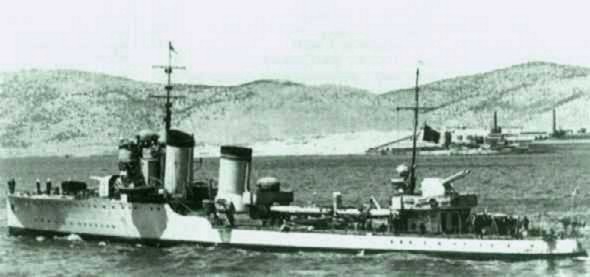 |
| Italian destroyer Crispi |
Operation Abstention, the English occupation of the Island of Castelrosso
On February 25, 1941, a large British commando landed on the island of Castelrosso, a small strip of land about 3 kilometers away from the Turkish coasts and about 80 miles east of the island of Rhodes and part of the Italian Aegean Islands. often called Dodecanese. The "Abstention operation" aimed to conquer the island, to establish a base from which to begin the conquest of the Dodecanese and thus to contest the Italian air-naval supremacy in the area of the Aegean and southwest coast of Turkey.
It should be emphasized that the idea of a conquest of individual islands with small groups of special forces men was an idea conceived and carried out by Admiral Andrew Cunningham, while the British command and in particular Prime Minister Winston Churchill were rather skeptical, due to the risk of creating friction between Greece and Turkey.
Before continuing the narration of the invasion, here there are two words on the island and how it became part of the Italian possessions.: In ancient times the island object of today's post was called Megisti (the largest) with reference to a group of adjacent islets. Its current name derives from the castle built by the Knights of San Giovanni who occupied the island in 1306 as a useful base before arriving in Rhodes. The Grand Masters of Rhodes considered it as a place in exile and sent the knights who violated the rules of the Order. In 1440 the island was sacked by the Mamluk sultan of Egypt and the castle badly damaged and in 1522 the Ottomans occupied it permanently.
Although not situated in the Aegean but in the East Sea, Castelrosso is historically part of the Dodecanese or Dodecanese archipelago which literally means "twelve islands".
At the beginning of the 20th century, as we have seen, the islands had been in the possession of the Ottoman Empire for almost 400 years, when in 1912 the Kingdom of Italy waged war by attacking the Ottomans in Libya and precisely in the Dodecanese. In the archipelago, on April 26, Stampalia was conquered, on May 12 Scarpanto, Caso, Piscopi, Nisiro, Calino, Lero, Patmo, Coo, Simi and Calchi, on May 4, troops also landed in Rhodes which was completely occupied on May 16th.
On May 5, 1912, the first of a series of commanders of the Aegean occupation corps, General Giovanni Ameglio, took office. The inhabitants of the island asked General Ameglio, commander of the Italian occupation forces in Rhodes, for their island to be annexed to Italy. This was refused and on March 14, 1913, the local population imprisoned the Turkish governor and his Ottoman garrison and proclaimed a provisional government.
In August of the same year, the Greek government sent a provisional governor from Samos, strengthened by a certain number of gendarmes: however, they were expelled by the inhabitants on 20 October 1915. On 28 December the French navy occupied the island thanks to the cruiser Jeanne d'Arc, acting in official support for the local pro-French faction; blocking also a new attempt of landing on the same day of a Greek contingent of Euzoni, chosen soldiers of mountain infantry of the Greek army.
The relations between Italians and the local population were quite good, both because our family ensured protection from Turkey, and because the Italian presence did not create large taxes, except for the prohibition of painting houses with blue and white colors, which recalled the color of Greek flag. The teaching of the Italian language was accepted without problems.
The Italians immediately connected the island with wire, on the continent and in 1926 the "Palazzina della Delegazione" was built by the architect Florestano Di Fausto, in colonial style. Two years later, due to the poor economic conditions of the island, many inhabitants emigrated to Australia and the Americas, significantly reducing the population that, at the beginning of the century, had reached the figure of about 15,000 inhabitants.
At the beginning of the 1930s the resident population was about 3,000 people, most of whom lived on remittances, trade with Lebanon and coal production destined for Egypt, while half of the houses were uninhabited. Some elections took place in 1928, 1930, 1932 and 1934. In 1937 the mayor was replaced by a mayor appointed by the government.
The 1932 Convention between Italy and Turkey, which defined the maritime borders between the two powers, assigned all the small islands of the small archipelago around Castelrosso - except for Ro and Strongili - to Turkey. Checova was one of these islands. During the 1930s Castelrosso constituted a landing point for French and Italian seaplanes. Between December 1933 and March 1934 there were popular protests caused by the tightening of customs taxation and the prohibition of indiscriminate cutting of the woods. All this caused another wave of emigration and in the 1936 census the population had further decreased to 2.236 inhabitants.
It is in this context that we arrive at the Second World War, during which the Italians used their bay for the incursions of the special units of the Regia Marina against the English naval base in Alessandria. The British admiral Cunningham decided to attack Castelrosso in February 1941
 |
| British Commandos landing in Castelrosso |
The initial plan provided for the establishment of a 24-hour bridgehead at Punta Nifti, pending the arrival of the occupation corps composed of the Sherwood Foresters regiment, which until then had been stationed on the island of Cyprus , and that it should have arrived on the island with the armed yacht HMS Rosaura and escorted by the Australian cruisers HMAS Perth and by the HMS Bonaventure.
The Italian presence in Castelrosso consisted of a small and heterogeneous group of soldiers and some agents of the Guardia di Finanza under the radio station of the island. Because of the darkness and the scarce knowledge of the island most of the lances went too far to land in the main port of the island where they came into contact with an Italian patrol.
Two Italian sailors were killed immediately and one seriously injured near the lookout station of Monte Vigla, but now the few and not well armed Italians for the defense of the island were aware of the operation and barricaded themselves first at Monte Vigla and then in Paleocastro, preparing for a strenuous defense by tenaciously rejecting the English attack.
Too much was the disproportion of forces in the field, the radio station was finally occupied by the English as well as the building of the Government Delegation at the entrance to the port and the customs building. In the action there were 6 dead, 7 wounded and 35 prisoners on the Italian side.
Before the radio station fell, the Italian operator was able to warn Rhodes about what had happened at the base and make the cryptographic codes useless so that they did not fall into enemy hands, so it was only a few hours later that he arrived on the island the Regia Aeronautica. The CR42 "Falco" fighters followed by some Savoy-Marchetti SM81 bombers struck the port, the outpost and the hills of the small island on which the commandos were installed. The operation was also made possible by the support of the former mayor of the municipality, Ioannis Lakerdis, of Greek origin, who reported to the Italians where to attack the British.
A few days later the Italian response to the invasion of the island would develop.
Image from the "Domenica del Corriere" of March1941 showing the Italian troops attacking the British commandos who have occupied the island of Castelrosso some days before: the Italian reconquest of the island enraged Winston Churchill

The Italian reaction to the British operation was a case not unique but very rare in the history of italian participation in the Second World War, in which the Italian Armed Forces reacted with speed and determination, demonstrating great organizational skills.
Already on the very night of the British occupation of the small island, the torpedo boats Lince and Lupo, the destroyers Francesco Crispi and Quintino Sella departed from Rhodes, and shortly after midnight on the 25th the Lupo moored in the port of Castelrosso and began to disembark the troops , a work that must soon be interrupted due to the rapid deterioration of the state of the weather and the sea.
The day of the 26th and the night of the 26th on February 27th passed quietly and without incident. All the British commandos slept in Punta Nifti except for the sentries and surveillance patrols. Food supplies were becoming scarce and they were rather angry at the failure of the forces that were to come to detect them. There was some real possibility of a counterattack from the sea and the commandos were now demoralized. For food, they counted on a few bags of Italian biscuits that they had seized in Paleocastro.
On the morning of 27 at 09.00, patrols of British commandos - located around the island to check the beaches and signal the approach of the long-awaited reinforcements that were to come to take over the contingent - sighted two Italian cruisers headed for the island . The arrival of Italian units in port caused panic among the British commandos.
The Lince and Lupo had indeed returned together with the MAS 541 and 546, and had been joined by Crispi and Sella, and at dawn the two torpedo boats began to disembark the troops north of the port. In all, 250 soldiers and 88 sailors were landed, most of whom were from the 4th battalion of the 9th Infantry Regiment of the 50th Infantry Division Regina under the command of Lieutenant Colonel Fanizza, who were to reconquer the island.
Soon the Italian troops took land by infiltrating along the streets and alleys that connect the center of the port to Paleocastro and towards the cemetery. They successfully attack by moving with tenacity and courage by rapidly advancing and regaining all positions, restoring the Italian possession of the island, capturing prisoners, weapons and ammunition (and an English flag).
An aerial bombardment also began which made the position of British troops even more difficult. At noon, the two English companies remained isolated, one at the cemetery and one at the landing place, there was no other choice but to retire by climbing the summit of the cliff overlooking Punta Nifti, known locally as Avlonia. Their armament was light and they did not have enough weapons and numerical strength to maintain control of the small coastal area where they had camped, so they decided to retire all together on the highest peak.
Italian planes and warships surround the island targeting any British military that they saw in short range. After the landing and the bombing the Lynx, together with the Crispi and the Wolf, began to patrol the waters south of the island and at 2.53, there was an unsuccessful skirmish between the Crispi and the British destroyer Jaguar, which closed at 3.30 without results.
The second wave of the British invasion force, commanded by Admiral Renouf, given the determination with which the Italian forces reconquered the island, is not landed and the convoy is ordered to retire and head towards Alexandria. It is indeed decided to evacuate the commandos, despite some of the patrols left around the island had not yet been traced in the dark.
Someone was captured the next day by the Italians, while someone else tried to reach the mainland in Turkey by swimming. Some of these later succeeded in being repatriated, and others were reported missing. On the afternoon of March 1, 1941 the commandos recovered returned to Crete.
The failure of the Abstention operation had serious repercussions at every level. Undoubtedly, the failure of the operation certainly did not help in the campaign of persuasion of Turkey to go to war against the Axis powers, as well as the negative trend of the operations of the Italian Armed Forces between the end of 1940 and the beginning of 1940, they convinced Francisco Franco, caudillo of Spain not to attack the English bse of Gibraltar and not to enter the conflict alongside the Axis powers.
It was obvious that something had gone wrong precisely in the first major offensive in the Eastern Mediterranean, diminishing the expectations of success in Britain's future plans in the Mediterranean.
Cunningham, the architect of this operation, clarified in the statement dated February 28, 1941 that the raid was to be considered only as an isolated attempt.
On the same day, Churchill was informed of Cunningham's statement on the outcome of the operation and immediately sent a telegram to Anthony Eden, Foreign Secretary in Cairo, saying:
"I am rather puzzled by something I have not yet been able to ascertain about what happened in Castelrosso. The report on Castelrosso does not explain exactly how many men have actually landed; where they landed; how much they have traveled; what they did; what prisoners they did; how many losses they have suffered; how it was possible that the enemy could have strengthened his presence from the sea when we were supposed to have maritime supremacy; what were the naval and military forces that strengthened the enemy; when and where they arrived; how was it possible that when the conquest of the island had already been announced, it was only then discovered that a large enemy warship had entered the port; if we have ever conquered the port and the defenses around it.
Anxiety has also increased due to numerous air attacks.
Was this predictable?
Where did it come from?
From the Italians or the Germans?
Please check these details.
For these reasons it is of vital importance to understand the entire sequence of this plan for you and our military. W.Churchill "
Churchill was very puzzled by the scant information received and addressed this further letter to the Chief of Staff General Ismay:
"I have been told only of the mystifications about this operation and it is the task of the General Staff to shed more light. I want to know how it was possible that the navy allowed the landing of so many reinforcements, when in such an affair everything depends exclusively on the navy's ability to isolate the whole island. It is necessary to clarify this point to prevent this from happening again during more important operations. No one should worry our nation that supports us in any way and it is therefore essential that such situations should never happen again. W. Churchill "
Churchill's interrogations forced Cunningham to give further explanations about the operation and the reasons why the Navy failed to isolate the island and take over the Commandos. Thus emerged all the divisions that existed between the Army and the Navy and it was clear how each one of them broke between them for this failure. The army pointed out that the proximity of the enemy air bases to Rhodes did not allow a large-scale defense of the island. On the other hand, the Navy replied that the Commandos' conduct in this operation had much to be desired. In his autobiography, Cunningham reports a letter he would later write to the First Lord of the Sea:
"The taking and abandonment of Castelrosso is a failed operation that gives no credit to anyone. The Italians were incredibly enterprising and not only bombed the island, but struck the targets with precision and landed their troops from the cruisers. Due to some unforeseen events, the army radio system did not work. These commandos were lightly armed and apparently could not be defended if seriously attacked. I had sent another 25 marines armed with machine guns aboard the Ladybird, but some madman then gave the order to re-embark them. The only thing we can say is that from this experience we have learned a lot and that we will not repeat the same mistakes. Cunningham "
These differences and these inconsistent visions of the incident inevitably led to an agreement settled between the various parties that took place on 12 March in Alexandria, Egypt. Even before the interrogation results were known, Churchill insisted on discovering the causes of this disaster:
"What other disciplinary measures should we take on this deplorable piece of wrong operations that happened after 18 months of experience in the war? W. Churchill "
With the questioning, new criticisms were raised about the navy's responsibilities for failing to isolate the island. However, the final results of the same have never been publicly disclosed as a British rule states that certain military information is not disclosed before at least 100 years have passed since the events and therefore these findings may be published no earlier than the year 2041 .
A total of 14 Italian soldiers died in the four days of the operation while 52 were wounded. 12 Italians were taken prisoners and a large number of weapons and ammunition were confiscated. The radio station, the power plant, the building and the Governor's house were seriously damaged during the clashes.
On the British side, 5 were dead, 11 wounded and 27 were missing during the hasty evacuation. Of these 27 missing, 7 were never traced again.
As punishment for assistance given by some locals to the British commandos, the Italians arrested 29 local male citizens suspected of "activities against the state" and were deported first to Rhodes, then to Coo and finally to Brindisi to stand trial. Many of these never returned to the island. The exodus of the population from Castelrosso continued uninterrupted.
With the failure of the operation the British renounced for the whole duration of the conflict to claim the Aegean islands and the military situation in the area will remain calm until the tragic days of the armistice, when following the collapse of the Italian military apparatus the English occupied Castelrosso and the other islands of the Dodecanese.
The serious mistakes made will be repeated on the night between 13 and 14 February 1942 during the "Daffodil operation", when the attempt to conquer Tobruk garrisoned by the forces of the "San Marco" battalion resulted in a disaster, with 779 dead and 576 wounded among the English commandos.
After the war an almost absolute silence fell on this Italian "victory" in Castelrosso. British historians even hardly mention it in their books.


