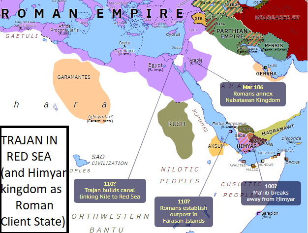
First of all we must remember the invasion of Arabia made by Aelius Gallus (the prefect of Roman Aegypt) in 25 BC. Then we have to write about the creation in the Farasan islands of a roman outpost around 110 AD and finally we have to study the Trajan conquests in the Red Sea region (with the Hymiar kingdom as a "Roman Client State").
Map showing Trajan achievements in the Red Sea region, with the Himyar kingdom as Roman Client State and the creation of the Farasan island roman outpost around 110 AD
Aelius Gallus expedition
Aelius Gallus was the 2nd ''Praefect'' of Roman Egypt in the reign of Augustus during the years 26-24 BC. His expedition to Arabia Felix, of which an account is given by his friend Strabo (Strabo, xvi. p. 780-783), unfortunately turned out to be a nearly complete failure (read http://rrimedia.org/Resources/Articles/the-romans-explore-western-and-southern-arabia).
During those years, actual Yemen was called "Arabia Felix" by the Romans who were impressed by its wealth and prosperity. Gallus undertook the expedition from Roman Egypt under Augustus, in order to conclude treaties of friendship with the Arabian people or to subdue them if they should oppose the Romans. Indeed, it was believed at the time that Arabia was full of all kinds of treasures: the success of the "Kingdom of Saba" was based on the cultivation and trade of spices and aromatics including frankincense and myrrh.
When Aelius Gallus set out with his army in 26 BC, he trusted to the guidance of a Nabataean called Syllaeus, who deceived and misled him.
A disease among the soldiers (unknown to the Romans) destroyed the greater part of the Roman Army during the initial invasion in northern Arabia. Gallus was forced to wait until next year in order to get his legionaries in healthy conditions. Only in 24 BC the Roman column of more than 10000 legionaries set off again, along the arabian routes to India, forcing the Romans to carry water on camels, due to the guide's lack of knowledge of the places. The journey lasted thirty days, but in the end the territories of the "king of the Tamudenes" were reached, and a certain Areta welcomed the Romans in a friendly way by offering Gallo gifts of welcome.
The next country invaded belonged to nomadic tribes and was totally desert. It was called Ararenê and it took 50 days to cross it, as there were no roads. Gallus then came to the city of Negrani whose territory was peaceful and fertile, and whose king had fled, leaving the city to the Romans.
He reached a river after six days, where the Arabs attacked battle leaving nearly 10,000 dead on the field, against only two dead Romans, not having adequate weapons and not being used to fighting (according to Strabo).
Successively Gallus occupied the Asca city, also abandoned by the king. Then the city Athrula, which surrendered unconditionally, where Gallus set up his own garrison to arrange the supplies of grain. He then arrived in Marsiaba (called also Ma'rib), which he besieged for six days, but had to give up due to lack of water. Gallus was thus forced to stop just two days' walk from the town that produced spices, reached at a high price after six long months of marching in inhospitable territories, mainly due to corrupt guides.
Realizing finally of Silleo's betrayal, he brought the decimated army back to Egypt. A new battle took place in Negrani. Then he reached Hepta Phreatae, which owned seven wells. From here, marching through a peaceful country, Gallus came to the village of Chaalla, and again to another village called Malotha, near a river. He crossed a deserted country with few irrigated places, to the Egra village on the sea. Strabo wrote that it took sixty days to return, against the six months of the first leg to reach Marsiaba.
Here he prepared a new fleet and crossed the Red Sea reaching Myoshormos, Coptos, and finally Alexandria in Egypt, where Silleo was tried and beheaded. Thus ended the bitter Roman adventure in the Arabian peninsula, after reaching Yemen.
Indeed the Arabs were not only not subdued, but Aelius Gallus, after having spent more than six months on his march into the country on account of his treacherous guide, was able to siege Ma'rib (the capital of the "Kingdom of Saba") for just a week. Meanwhile his Roman fleet occupied and destroyed the port of Eudaemon (actual Aden) in order to guarantee the Roman merchant route to India. He was then forced to do a retreat in sixty days, obliged to return to Alexandria of Egypt having lost the greater part of his force.
The famous historian Theodore Mommsen wrote that Aelius Gallus sailed with 10,000 legionaries from Egypt and landed at Leuce Kome, a trading port of the Nabateans in the northwestern Arabian coast. He then conquered without difficulty Iathrib (actual Medina) and the village of Mekke (actual Mecca). From there he made a march of nearly one thousand kms to the south until Marib, but was forced to abandon those conquests -according to Mommsen- not only because of diseases and epidemies, but even because he had overextended his line of supplies from Egypt in a land full of deserts.
However Augustus promoted the commerce toward India and welcomed the destruction of the Aden port by Gallus. Furthermore, he wanted to circumnavigate with his fleet the full Arabian peninsula from the Mesopotamia borders and successively reach the eastern coast of Africa toward Raphta in southern Africa (probably in order to reach the Gibraltar strait and circumnavigate Africa). But the tentative of one of his relatives finished in a sinking disaster near actual Gibuti (ex-French Somalia).
The Farasan roman garrison & castrum

The Farasan islands history goes back two thousand years. The first historical references are related to the Roman presence in the islands with a garrison and a recently discovered "castrum". The Romans created a local Prefecture under their direct control in order to fight the pirates, who attacked their merchant ships doing commerce travels from Roman Egypt and the south-eastern Mediterranean region in their commerce travels to India.
The islands were only 60 miles from the main Saba port of Muza in the western Arabia peninsula and 120 miles from the important Ethiopian port of Adulis on the western shore of the Red Sea. It was also not too far from the rich pearl fisheries in the Strait of Bab-el-Mandeb at the southern entrance of the Red Sea. The garrison, along with elements of the Roman fleet, could have helped suppress pirates and protect the nearby ports, pearl fisheries, and Nabataean trading settlements in Somalia, as well as serving as a customs outpost.
''...inscription (of 144 AD) reveals a new phase in the Roman occupation of Farasan, and also attests the existence of a Roman 'Prefecture of the harbour of Farasan and of the Herculian Sea’ :"praef(ectus) Ferresani portus(?) et Pont(i) Herculis". The prefect’s sphere of responsibility thus covered not only the Farasan islands but also an area called the Herculian Sea, which, as the editors convincingly maintained, must surely have been a term for the southernmost part of the Red Sea and the straits of Bab el Mandeb.Michael Speidel (M. Speidel, "Heer und Herrschaft im Römischen Reich der Hohen Kaiserzeit", Stuttgart 2009, 633-649)
Michael Speidel wrote in 2012 that there was a Roman garrison (with legionaries from the Legio VI Ferrata) in a "castrum" located in the Farasan main island, with a "Roman Prefect" of the Herculean sea (term related to the Bab el Mandeb strait, similar to the "Hercules strait" as roman called the Gibraltar strait). In his opinion the prefecture (that implied direct roman control) was created when Trajan conquered the Nabatean kingdom in 105 AD and had the responsibility to defend the area of southern Red sea from pirates.
According to Speidel, archeological evidences -2 tablets written in latin language- demonstrate that the Roman garrison remained for sure in the Arabian island at least for nearly half a century (and possibly until Septimius Severian times).
Successively the island remained practically deserted until the XV century, when some fishermen established a small outpost in the island.
Indeed in the Farasan Islands two latin inscriptions were discovered in 2003. The first inscription attests the presence of a vexillatio of the Legio Traiana Fortis, that in 143 AD moved from the roman province of Egypt under the emperor Antoninus Pius. While the second inscription attests the presence of the Legio VI Ferrata in 139 AD, that moved from the roman province of Arabia Petrea under the emperor Hadrian.
The second inscription recently discovered dates to 143-44 AD and was done by garrison commander Castricius Aprinus, described as "Prefect of the Port of Farasan and of the Sea of Hercules" (actual Bab-el-Mandeb). The title indicates the formality of Roman occupation and its wide ranging scope. Aprinus was also from the Roman legion stationed in Egypt.
The Himyar kingdom: a roman Client State
Professor D. Nappo wrote that "...The Roman Empire showed a very distinct interest for the Red Sea area along all its history. This was due to the crucial role played by such region in both military and commercial Roman plans to expand its own influence in the East. The first echo of a military attempt to conquer the north eastern shores of Africa beyond Egypt dates back to the age of Augustus, but it is with Trajan that such project seems to reach a new level of coherence and strategic view. Under the latter, in fact, we have evidence for a climax in the Roman control over the area, which had important consequences on the history of the region for decades ahead....
The annexation (done by Trajan) of the Nabataean Kingdom in 106 AD and its subsequent connection to the Roman road system, the restoration of the canal on the Nile (called "Trajan canal") in 110 AD, and the occupation of the Farasan Islands are not separate actions, but rather distinct components of a larger master plan. All aspects of Trajan’s policy in the East make much more sense when considered from this perspective: tighter control of the two ends of the Red Sea was the best way to secure control of the whole region of the western Arabia peninsula.
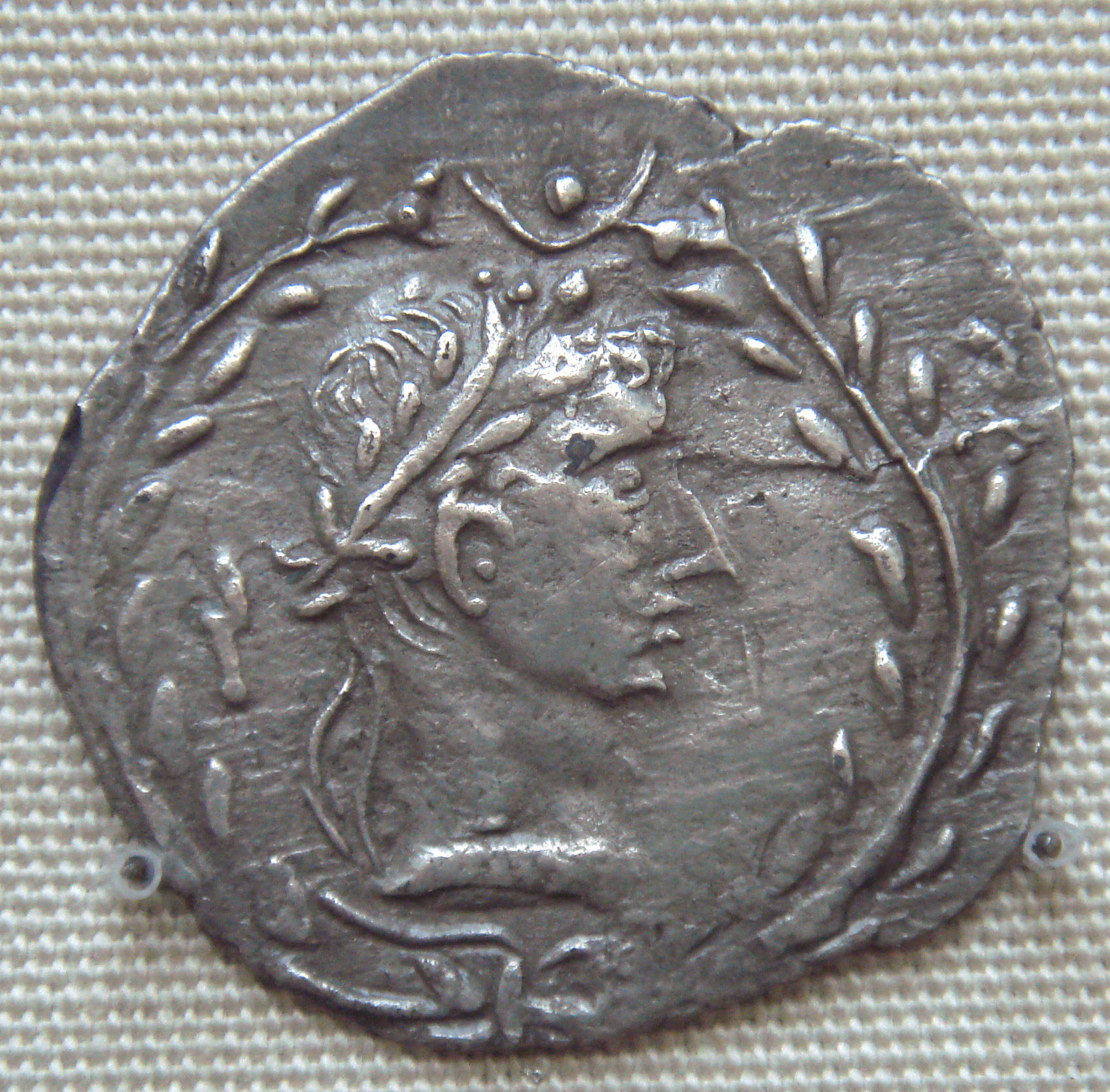
Coin of Himyar kingdom showing Roman influence and depicting a likeness of Augustus
It is noteworthy to pinpoint that the Red Sea was a key area in the international trade route between the Roman Empire and the Far East (generally referred to by the Romans as ‘India’).
This commerce was extremely important for the economy of the Roman empire and -in order to defend and promote this trade- Trajan occupied the northern region of western Arabia (recently further evidence has been discovered that Roman legions occupied Mada'in Saleh in the Hijaz Mountains area of northwestern Arabia, increasing the extension of the "Arabia Petraea" province) and promoted the creation of a Roman Client State in the actual Yemen/Aden territory (the Himyar kingdom).
Indeed in AD 106, the Romans conquered the Nabataeans and brought an end to the rule of King Rabel II. Under Roman control, Bostra —Rabel had shifted the Nabataean capital from Petra to Bostra— was renamed "Nea Traiane Bostra", after the emperor, and it was there that the base camp of the Third Cyrenaica Legion was established. For the next five years, Roman legionaries worked to fortify defense boundaries, establish control of the new province, and build the great road from Bostra to Aqaba —the "Via Nova Traiana"— which ran the length of the province. In 111 AD, Rome publicly announced the successful annexation of Roman Arabia and the completion of the great road, and issued Trajanic coinage advertising the annexation. The new province became one of Trajan's legacy in the Middle East.
Trajan also had good relations with the Himyar kingdom, located in the area of actual Yemen/Aden. The famous "Periplus of the Erythraean Sea" describes the close relationship between the king of this southeastern Arabia kingdom (named Charibael) and the Romans in the first century C.E.:
...And after nine days more there is Saphar, the metropolis, in which lives Charibael, lawful king of two tribes, the Homerites and those living next to them, called the Sabaites; through continual embassies and gifts, he is a friend of the (Roman) Emperors.
Charibael is usually identified with Kariba-il Watar Yuhan'im, who ruled Himyar sometime between AD 40 and 70 AD. According to the author of the Periplus, he is said to dwell in Saphar and to maintain friendship with the Roman emperors by means of "continual embassies and gifts"; he is said to exercise control over the towns of "Muza" (Mocha) and "Saua" (Taiz) in "Mapharitis" through a "vassal-chief" named "Cholaebus" (Kula'ib). From the Roman merchants calling at Mocha, he used to require tribute of "horses and sumpter-mules, vessels of gold and polished silver, finely woven clothing and copper vessels". In the Periplus was written that his realm included "Ocelis" at the Bab-el-Mandeb strait and the ruins at "Eudaemon Arabia".
During Trajan’s reign, the Romans established a legionary garrison on Farasan island (called "Portus Ferresanus" in Latin language), in the southern Red Sea off the coast of southern Arabia, possibly to guard the lucrative trade routes passing through the strait of Bab-el-Mandeb. Farasan—conjectured to be the southernmost point of the Roman Empire—may have originally been an outpost of the Nabataean Kingdom and initially administered from the Roman province of Arabia, but by 144 AD it was being governed from Egypt.
Probably the Romans used the garrison on the Farasan island to show support for the Himyar kingdom during Trajan years, against nearby enemies. This help was at the root behind the creation of "client states" by the Romans. How long this station lasted is uncertain from the scant archaeological record, but it was probably abandoned by the end of the Crisis of the Third Century (235–285). At the same time the friendly relations between Rome and the Himyar kingdom finished.
Sometime around 140 AD the old personal union between the Ḥimyarite Kingdom and the Kingdom of Saba seems to have broken, restoring Saba’s independence. Following this, the two kingdoms became increasingly hostile to each other, fighting wars on several occasions over the next 120 years. The breakup of this union may also have ended Roman influence in Ḥimyar, which stopped producing coins depicting the likeness of Augustus by the end of the 2nd century.
Finally it is noteworthy to pinpoint that the Romans -who mastered engineering knowledge for acqueducts- helped the Himyar kingdom to reinforce and maintain the famous "Marib Dam", according to the historian Theodore Mommsen.
Image of how was the original Marib Dam, reconstructed with Roman engineering knowledge

Indeed the dam was under the full control of the Ḥimyarites since Augustus times. They undertook further reconstruction, creating a structure 14 meters high with extensive waterworks at both the northern and southern ends, five spillway channels, two masonry-reinforced sluices, a settling pond, and a 1000-meter canal to a distribution tank. These extensive works seems to have been started at the beginning of the second century (exactly when Trajan ruled the Red Sea, with the "Himyar Kingdom Client State") and were totally finalized only around the end of the Third Century.
The Marib Dam allowed the irrigation of 25,000 acres (100 km2) and it was one of the most wonderful feats of engineering in the ancient world.