Orkney: the 6th province of Britannia? New evidences from Mine Howe
I want to add -at least partially- this essay to my personal researches on the Roman presence in the British isles.
But in my opinion that is not true, and I am not alone with this point of view. Let me explain better:

We all know that during the Roman invasion of Britain the "King of Orkney" was one of 11 British leaders who is said to have submitted to the Emperor Claudius in AD 43 at Colchester (called Camulodunum in latin). What we don't know is the exact extension of the territory controlled by this king, who successively was probably- as Romans used to do in this situations- the ruler of a possible "client-kingdom" of the Roman empire.
However there is certainly evidence of an Orcadian connection with Rome prior to AD 60 from pottery found in the Orkney islands at the "Broch of Gurness" (and we must also remember that 1st and 2nd century Roman coins have been found at the "Lingro Broch").
When Agricola -according to Tacitus- in 84 AD conquered all Scotland defeating the "Caledonians" with his victory at the "battle of Mons Graupius" (that probably happened near the recently discovered Cawdor fort in the Inverness area, or further east near the Bennachie hills), he sent a fleet to the northernmost shores of Britannia.
This reference by Tacitus to these Roman ships arises some questions:
1) Why Agricola sent north a fleet and not units of his legions?
2) Is it possible that this happened because he was aware that the tip of Britannia was ruled by the king of Orkney (or his sucessors), who was an ally (or a client-king) of Rome and consequently there was no need of a military expedition?
3) And why Agricola needed to explore the Orkney islands if he already knew of them since their "submission" to Claudius a few decades before....or may be he needed to send roman ships (with some troops) to "take REAL possession" of the islands for Rome's empire?
4) If "subdued" the Orkneys island in the autumn months of 84 AD, as wrote Tacitus - is it possible that the Romans started in the winter 84/85 the process -later abandoned in spring/summer 85 AD- of creation of a new province of their empire (as they did with the "Germania provincia" before the Varus defeat)?
These questions are not easy to answer, but archaeological evidences clearly indicate that the Romans traded extensively with the Orkney inhabitants, according to scholars like Montesanti, who wrote that "Orkney might have been one of those areas that suggest direct administration by imperial Roman procurators, at least for a very short span of time".
Furthermore, we have to remember that Tacitus wrote that under Agricola "Britannia perdomita est" (Britain is fully dominated), where the word 'perdomita' in latin is a reduction of the words "PERfecta DOMInaTA" (in English: totally conquered/dominated). Of course Agricola -after his victory against the Picts (called "Caledonians" by the Romans) at the battle of Mons Graupius in the fall of 84 AD- in spring 85 AD was ordered to leave Britannia and went back to Rome, so he could not consolidate his full control of all the huge island of Britain. Romans soon dismantled also the big Inchtuthil fort in the 'Gask Ridge' and went south of what is now the 'Antonine Wall', losing control of Caledonia after only a few winter months of full rule. But the Roman links with the kingdom of Orkney remained, as Montesanti wrote in his researches.
Archeologist Andrew Kizpatrich is another scholar who think that Orkney did have tangible links to Rome: he concentrated on the shards of Roman amphora found at the "Broch of Gurness" (in the main island of Orkney) - an amphora of a style that had become obsolete by AD 60. Roman goods of these dates were rare further south in Scotland, which would imply that, some time before Agricola invaded Scotland, the Orcadian inhabitants of Gurness had links and access to Roman goods.
Fitzpatrick suggested that kings/chieftains in
Orkney had connections (either through marriage or military alliance)
with tribes in the far south of Scotland. This could explain the
number of broch-like structures
in the Lothian region. Fitzpatrick went so far as to suggest
Orkney links with tribes in Essex who were known to have submitted
to Claudius.
The Roman practice of establishing "puppet"
kingdoms along its expanding frontier could be related to the Claudius
and Agricola reference - did the Roman invaders form some kind of
alliance with certain powerful families in Orkney that benefited
them both? It is certainly possible.
The same may have been the case with Agricola's
alleged conquest of Orkney in AD 84, in which he is reported by Tacitus to have
"discovered and subdued" the islands.
As we all know, after Agricola's withdrawal -and the creation of the Hadrian Wall and the Antonine Wall- the Romans did only one strong tentative to dominate all Caledonia: under emperor Septimius Severus. By 210 AD, Severus' campaigning had made significant gains probably reaching the Inverness area (Muiryfold), but his campaign was cut short when he fell fatally ill, dying at Eboracum (actual York) in 211 AD. Although his son Caracalla continued campaigning the following year, he soon settled for peace and went back to the Hadrian Wall.
Map that I have created for Wikipedia, showing Cawdor, Muiryfold, Tarradale & Portmahomack location in Caledonia (actual Scotland)
 But we don't know exactly where Caracalla's legionaries stopped their advance in north Caledonia. Probably they reached Portmahomack, as recently discovered evidences suggest.
However, is it possible that Caracalla's ships reached the Orkney islands, as happened with Agricola? Montesanti hints that it could have happened.
Map that I have created for Wikipedia, showing Cawdor, Muiryfold, Tarradale & Portmahomack location in Caledonia (actual Scotland)
However, is it possible that Caracalla's ships reached the Orkney islands, as happened with Agricola? Montesanti hints that it could have happened.
Indeed in 1984, a candidate for a Roman fort was identified by aerial photography at Easter Galcantray, south west of Cawdor (near Inverness). The site was excavated between 1984 and 1988 and several features were identified which are supportive of this classification. If confirmed, it would be one of the most northerly known Roman forts in the British Isles.
Additionally, the possibility that the legions reached further north in Scotland is suggested by discoveries in Easter Ross. The sites of temporary camps have been proposed at Portmahomack in 1949, although this has not been officially confirmed. In 1991 an investigation of Tarradale on the Black Isle near the Beauly Firth concluded that "the site appears to conform to the morphology of a Roman camp or fort."
But it is Count Theodosius (the father of emperor Theodosius I) the one that could have created (or recreated) this "Orcades provincia" around 369 AD. Claudian narrate numerous exploits of Count Theodosius, who -after creating the "Valentia provincia"- would have penetrated to the remote region of northern Caledonia where he would have inflicted a resounding defeat to the Picts; later with his fleet he would have sailed as far as the Hyperborean Ocean, and there he would have inflicted a naval defeat on the Saxon pirates at the Orkney islands.
Claudian wrote in Latin (Claudian, De IV Consulatu Honorii Augusti, 25-35 ): "maduerunt Saxone fuso Orcades", that translated in english is "the Orcades turned to red color because of the massacre of the Saxon (pirates)".
Of course, the Claudian reference of Count Theodosius does not mean that we have a sure evidence of the establishment of this "Orcades provincia"…….but nothing indicates the contrary. Indeed 4th and 5th century classical sources (like Polemius Silvius, who lived a few decades later, in the mid fifth century) include the Islands in a Roman province:
In a late document ("Nomina Omnium Provinciarum" of Polemius Silvius, Laterculus II), Polemius Silvius listed all the Roman provinces, including the
Diocese of Britannia: (Britannia) Prima, (Britannia) Secunda, Maxima, Flavia, Valentiniana, and the
name of the 6th hypothetical province called Orcades (Orkneys). Although the name of latter in
Polemius’ list has been considered by Mommsen as an interpolation added subsequently (Eutropius,
7.13), new Roman archaeological finds from Mine Howe, Mainland, Orkney, might represent the
evident clue for a different interpretation of the late Roman source.
It is difficult to understand why Polemius Silvius "created" this "Orcades provincia", if it is a fake (or a mistake) as some historians like J. Hind (https://www.jstor.org/stable/4435428?seq=1#page_scan_tab_contents ) argue. And we have to remember that in all his other works P. Silvius showed no mistakes.....Anyway also about the existence of the "Valentiniana" province (called often "Valentia") there are some scholar's doubts, but it seems that archeological evidence is demonstrating in recent years that Valentiniana existed really (even if for a very small period of time).
 |
| Map of Roman Britannia in 410 AD showing the province of "Valentia" in southern Scotland |
And this "Valentia province" existence means that Roman presence in actual southern Scotland lasted more than one century - and may be nearly two centuries, or more! In the locality called Bremenium (actual High Rochester; see http://www.wildyorkshire.co.uk/naturediary/docs/2001/8/16.html) and Habitancium (actual Risingham, see above map) there are evidences of Roman occupation for all the second, third and fourth century (and beyond, possibly in Sub-roman years): see https://www.u3ahadrianswall.co.uk/wordpress/risingham-roman-fort-habitancum/.
Of course this is a clear demonstration that the opinion of some modern British historians about the Roman presence in Scotland lasting just 80 years is a complete mistake!
EXCERPTS FROM MONTESANTI'S "ORKNEY: THE 6TH PROVINCE OF BRITANNIA"
(https://www.academia.edu/33336307/Orkney_the_6th_province_of_Britannia_New_evidences_from_Mine_Howe)
The archaeological site of Mine Howe Mine Howe (HY 5105 0603, OR 63) is a glacial-looking hillock (c.95m in diameter) lying within the parish of Tankerness on Mainland, Orkney. Excavation campaigns undertaken between 2000 and 2004 revealed a unique middle-late Iron Age ‘ritual’ complex based on three different main features: one underground structure, a massive ditch surrounding the mound and a sub-circular structure identified as a workshop. The underground laddered structure was built into the core of the sub- circular glacial with fine drystone masonry. The body of the construction is formed by two flights of stairs at the base of those a well-shaped main chamber is located and roofed by a corbelled stone roof capped. A very substantial ditch surrounding the mound interrupted by a single entrance to the W was also investigated)
All the context from the ditch and the workshop contained large amounts of artefacts, but few of them are specifically Romano-British (MacSwean 2001): on 10433 small finds, collected in 5 excavation campaigns, just 220 of them have been considered Romano-British artefacts, which represent 2.1% ca. of the total. Of those 220 objects, 68 may be considered as Roman or Romano-British, 46 may be deemed as an interaction between Natives and Romans, while 59 might be considered purely Native. The remaining 47 artefacts, which it was not possible to assess, have been considered as ‘dubious’. The Romano-British materials of Mine Howe have been analysed through comparisons to understand their depositional function, use and chronology.
More fragments might be recognised as medical or surgery tools are already recognised as a nail and might be a surgical one. Three perfectly polished bone fragments of spatulas tools (s. Hedges 1987, 88; 110-1), which may be hypothesised as Romano-British, might have been assumed, together with the metal instruments, by function as part of a medical kit. Different copper alloys were used for instruments, medicament-boxes (Scrib. Larg., Comp., 27) and chiefly for spatula-probes (Marcel. Emp. 14.44; Paul. Aegin. 6.77). The dating of Roman instruments is extremely difficult because their standard typology seems to remain unaltered over the centuries. Collections of similar medical instruments from Pompeii, from the ‘Surger’s House’ at Rimini (Jackson 2002) and from the ‘camp doctor’ at Bingen upon Rhine on the frontier (Keunzl 1982) provide some criteria of comparisons with a chronology between 79 A.D. and end of 3rd century [Fig. 12.08.2]. In Britain, surgical instruments have been found at Richborough, by the site of a Roman camp as well as the most important comparison with the ‘druid’s tomb’ of Stanway, Colchester, Essex, which presents various connections with Mine Howe.
At the outset of the invasion, Rome had been interested in British minerals and their exploration followed everywhere rapidly upon the advance of the armies (Tac. Agr. 12). The presence of the Romano-British world on Orkney might be considered now as the strongest evidence in a non-occupied area as well as some striking comparison. In Hampshire, for instance, between the 1st centuries B.C. and A.D., we notice some changes such as the introduction of the potter’s wheel, cremation burial and the use of shrines/temples and coinage. The Chichester complex became the centre of an important Roman client kingdom after the conquest in 43 A.D. (Hill 1995:9; Cunliffe 1993). Again, in Derbyshire, the Matlock mines were an industrial settlement (Gowland 1901:381-4; Cox 1905:227-232; Richmond 1958:42-43). At Poole's Cavern, metalworking is part of a much wider set of casting activities on Romano-British sites. At Bolsover, the construction of extensions to the local authority headquarters identifies a Romano-British ‘oval’ enclosure, within which a defined area appeared to be dedicated to various industrial activities including iron smith (Sumpter 1992; Jones & Thompson 1965; Myers 2000:6). At Bardown, Wadhurst (near Pevensey) a series of five furnaces were built on an industrial scale and were linked with the process of iron working (Cleere 1970:1-23). In Scotland, three different types of relationships carried out by the Romans in a doubtful and still debated 4th century province of Valentia (Mann 1961; Foord 1925).
In comparison with other Romano-Celtic (British) settlement develops around a sacred place unusually rich in votive evidences: at Buxton, the fulcrum is represented by a natural hot and cold springs cult, during the AD 3rd and 4th centuries (Myers 2000:4; Hart 1981:94); at Thirst House Cave, high qualitative brooches and earrings have been deposited within the cave between the late A.D. 1st and mid-2nd century (Branigan and Bayley 1989:49; Myers 2000:5). In both instances, there is a significant representation of Roman metalwork including brooches, chatelaine, nail, tweezers and ear scoops (Hart 1981:105). However, Mine Howe shares, with the rest of Orkney brochs, typology, quality and quantity of some common Romano-British artefact with the difference that those from Mine Howe seem to belong to one status and function at an upper level. The main differences between them consist in the fact that the finds in the brochs conclude their chronological horizon at the first two centuries A.D. and are limited to decorative elements (MacGregor 1976:177-8). The objects found at Mine Howe have some similarity with the ones brought to light at Traprain Law (Cree 1923) and Fairy Knowe (Robertson 1970:200; Burley 1956:219-221).
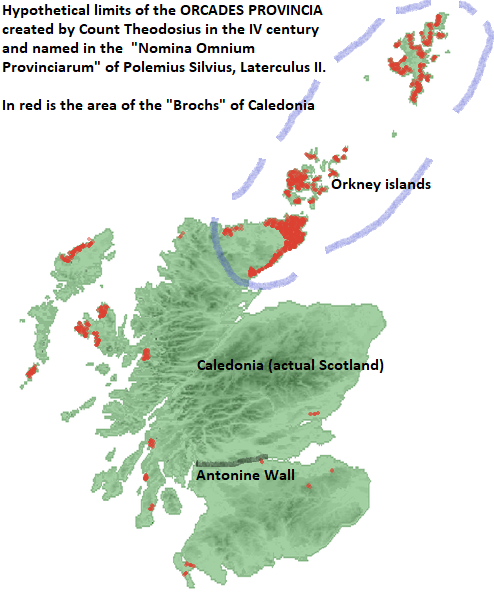 |
| The above map shows the hypothetical area ot the Roman "Orcades Provincia" created -possibly- by Count Theodosius around 370 AD and that could be the reason of why Polemius Silvius a few decades later wrote that there were six Roman provinces in Roman Britannia. Note that the limits are closely related to the presence of the "Brochs", that could mark the area under rule of the King of Orkney (who submitted to emperor Claudius in 43 AD). |
Roman materials of Mine Howe are limited for quantity and dimensions, even though not in quality. The most representative phases by artefacts are those which represent an unusual peak and might belong to the phase following the invasion of Agricola. Some glass fragments, fibulae might be linked with the amphora shards from the Broch of Gurness (Hedges 1987), related to a hypothetical Claudian invasion (Fitzpatrick 1989), even if ‘Haltern 70’ amphorae are well known in Britain just after the Flavian Period (Tyers 1999:97). The hypothesis is obviously based on the solid fact that the centre of resistance lay in the extreme North (Tac. Agr. 10) and the Orkney were considered to complete the conquest of the whole of Britain (Tac. Hist. 1.2; Richmond 1958:52). The Roman finds at Mine Howe seem to bear a chronological identification from the Flavian until the Hadrian period. Then and after a symptomatic lack/absence of further evidence, the relationships seem to start over from the Severan reorganisation. The occurrence both of high status and magical/healing and warlike artefacts is also taken as a direct indicator of characteristic activities at or around Mine Howe, enlightening the symbolic and ritual significance of the site also involved in the process of metal artefacts production (Sharples 1998:205; Card & Downes 2003a:17). The Romans might have chosen Mine Howe, one of Orkney’s key point, for the evident sacred role of the ditched underground structure and the related workshop. The outpouring of Romano-British materials is argued to be the direct response to the social thread posed by Rome to create and reinforce their own identity in the face of external threats. In this sense, Native key points or places would have been played an important role in craft production or trading exchange: the existence and the peculiar location at Mine Howe of a smithy/workshop would enhance the status of the site (Hodder 1982:1986-7; Jones 1997:113-5, 123-4; Hunter 2006:105; Hill 1995:9).
By contrast with Traprain Law, the lack of a massive presence of Roman pottery confirms the absence of Roman settlers as first indicator of any Roman activity. However, it would be plausible that Orkney might have been one of those areas that suggest direct administration by Imperial procurators, at least for a very short span of time. And this might have occurred twice in Orkney’s history. These archaeological hints might relate to an ‘unexpected’ Roman presence in 4th century in the symbolic site of Mine Howe and linked with the elusive notice of the intangible sixth province of Britannia, Orcades, pointed out on the Count Theodosius’ campaigns (Nomina Omnium Provinciarum of Polemius Silvius, Laterculus II; Eutropius, 7, 13, 2-3; Hind 1975:101; Steven 1976: 211-224; Birley 2005:399, n.2). These re-discovered objects might represent a brief but intense link for the actual issue of negotiated relationships between Natives and Romans. Yet, they may provide an innovative interpretation and a new meaning for individual deposits towards an understanding of their effect between people and material forms, artefacts and material actions.