Thursday, December 1, 2022

JULIAN-DALMATIAN EXODUS & DIASPORA (1944-1954)

The following is a translation in english of some excerpts of a research done by Michele Pigliucci, about the nearly complete disappearance of the italian community in the "Venezia Giulia" and "Dalmazia" regions of Italy during the ten years after the end of World War 2. This disappearance has been defined by some historians (like Sabbatucci) with the word "ethnocide" (mainly in Dalmatia, where the italians of Dalmatia are now reduced to only a few dozens!).

The Italians of "Piemonte d'Istria" exiled in 1954 in Trieste. Photo done in 1959

"La diaspora dei giuliani e dei dalmati: una ferita ancora da sanare" (The diaspora of Julians and Dalmatians: a wound still to be healed), by Michele Pigliucci

The Julian-Dalmatian exodus refers to the mass migratory phenomenon that occurred between 1944 and 1954 which involved a substantial percentage of the inhabitants of the Italian region Venezia Giulia, a geographical region enclosed between the Julian Alps, the Isonzo river and the sea, and including the Gorizia karst , the Trieste karst and the Istrian peninsula up to the Gulf of Quarnaro.

The phenomenon largely occurred after the cessation of hostilities during the Second World War, at the end of which almost all of the Venezia Giulia region had passed under the sovereignty of the Federal Republic of Yugoslavia; it was a phenomenon that involved the majority of the Italian population of the region, who decided to abandon their homes to flee to Italy, often in a daring way, taking with them what was possible to close in a chest or pile up on a cart and often even the coffins containing the remains of their own deads.

The figures referring to the extent of the phenomenon have often been manipulated for political interests, oscillating between the three hundred and fifty thousand mentioned by Father Flaminio Rocchi and the two hundred thousand reported by the Slovenian scholar Zerjavic.

But the most reliable figure is that of the "Opera Profughi" (Opera Refugees), who took a census of 201,440 people to which the historian Raoul Pupo believes it is necessary to add the number of those who for various reasons escaped the count, thus arriving at a reliable total of just over three hundred thousand people.

This is almost all of the Italian population in the area, an exodus of dimensions indeed impressive, unprecedented in the history of Italy.

When Italy signed the armistice in september 1943, the Yugoslav partisans of the Popular Committee for the Liberation of Istria proclaimed from Pisino (actual Pazin in central Istria), with a nationalistic language, the return of Istria to the Croatian motherland, and occupied the whole region left without any political and military authority; established people's courts with which they began a ferocious liquidation of Italians (but also of some fascist Slovenians and Croatians) accused of being enemies of the people.

Several hundred people disappeared in those few months when drowned in the sea or shot on the edge of a foiba, often thrown alive and after being tortured; the victims were both military and civilians with positions during the regime, but also people completely unrelated to fascism such as Norma Cossetto, a university student who was arrested and raped by several men before being thrown alive into a foiba.

The region (after a few weeks of partizan occupation) remained under German administration up to spring of 1945, when the last Allied advance got the better of the exhausted Nazi-fascist troops: the 4th Yugoslav Army also took part in the offensive -which was ordered by Marshal Tito- to give the absolute precedence to the full occupation of Trieste. The city was reached on May 1 even earlier than Lubliana, just one day earlier than upon the arrival of New Zealand soldiers. It was the so-called «race for Trieste», which Tito knew was strategic for the purposes of the future structure geopolitics of the area.

With the withdrawal of the German troops and the definitive disbandment of the departments of the Italian Social Republic, all of Venezia Giulia was also occupied by the Yugoslavs who resumed arrests, summary trials and eliminations of those who for various reasons were denounced as enemies of the people by the many informants in the area. After forty-two days of occupation the Yugoslavs left Trieste, Gorizia and Pola while the rest of the istrian territory became de jure Yugoslav territory (with the exception of the north-western coastal area up to the Mirna river which will constitute the "Free Territory of Trieste" until 1954).

It was then when began the "exodus" of the Italian population, whose origin can be traced back to three reasons: one linked to security, one political and one national.

The flight of the Italians was above all a reaction to the liquidations and the violence implemented by the Yugoslav regime and in particular by the secret police, the OZNA. The large number of people disappeared and killed in sinkholes (called "foibe" in italian) throughout the territory greatly frightened the Italian population, so much so that historian Sabbatucci does not hesitate to speak of "ethnic cleansing" towards the Italians, convinced that there was precisely behind these liquidations the will of modify the ethnic structure of the territory by eliminating the Italians especially before the Peace Conference defined sovereignty over the area.

The political motivation, consisting in the desire not to submit to a communist regime, then played a fundamental role both in the Italians of the exodus and in the "remained" italian community (confident in the nascent regime) and both for the Italian workers who decided to cross the border in the opposite direction in order to do adherence to the ideal of socialism. Many of those workers, however, will be persecuted as "cominformists" after the break between Tito and Stalin.

Finally, it affected the choice to flee also the national identity, on which the exile memoir insists a lot, which often tells of a voluntary exile, motivated by the desire to continue living in an Italian land. The strong national sense of these populations, on which they had Irredentism and Fascism, and the millenary rivalry with the Slavs, found fertile ground and certainly contributed to this choice. In the first post-war years, together wjth the violence, the regime titino undertook a work of Slavicisation of the region similar to that of Italianization conceived by fascism: the Italian shop signs, the use of the Italian language was substantially prohibited, many Italian schools were closed and it was banned enrollment in the same to all children whose surname ended in «-ch», automatically considered Italianized Slavs.

The five exodus waves

The exodus materialized in five main waves corresponding to as many historical events:

1) A first wave followed the fierce Anglo-American bombing of Zara, whose inhabitants had already sought refuge in Italy in 1944: the abandoned city would later be occupied by Tito's partisans and the Italians would never return.
2) The second wave followed the definitive annexation of the vast majority of the Istrian region, Fiume and the Dalmatian lands in June 1945.
3) A third wave took place in the winter of 1947, when also Pola passed under Yugoslav control following the signing of the Peace Treaty: in the city there were tens of thousands of inhabitants (nearly all the "Polani") who decided to embark to reach Italy.
4) In 1948 a new wave affected the communists who had wanted to stay or who had moved to Tito Yugoslavia and who, after the Tito's expulsion from the Cominform in 1948, had ended up as enemies of the yugoslav regime because loyals to the Partito Comunista Italiano.
5) The last big wave finally occurred in October 1954, no less than nine years after the end of the war, when the London Memorandum established the passage of Trieste to Italy but handed over to Yugoslavia the coastal area from Capodistria (now called Koper) up to the river Quieto (now called Mirna).
.
The arrival of the exiles on the national territory in 1945 and 1946 was the cause of harsh political disputes: the docks of the ports of Venice and Ancona they hosted, upon the arrival of the steamers, protest demonstrations from the side of dock workers who accused the Giuliani of fascism as fugitives from a communist regime. Disembarked on land, the exiles were then sorted onto the various trains that would take them to the 120 refugee camps scattered throughout Italy to host them as best they could: during the passage of one of these trains to the Bologna station, the workers even threatened to strike if the authorities had allowed the convoy to stop to receive the comfort of the Red Cross.

The Communist Party helped to spread hostility towards the exiles even in the final destinations of the journey, favoring the identification of the Giulians with war criminals forced to flee from Venezia Giulia to escape the reaction of their victims. This distrust spread significantly in Italy, also fueled by the precarious living conditions in which the exiles found themselves in the refugee camps.

In accordance with this attitude of mistrust the historiography official has ignored for decades the extent and sometimes the very existence of this tragedy. Still in the 90s of the twentieth century the manuals only marginally reported this page of history, which survived relegated to neo-fascist political propaganda and the memoirs of exiles. The bad reception given to refugees on the docks of the ports and in the stations was the prodrome of a more general removal not only of the story of the exodus, but also of much of the history of the Italian presence in Venezia Giulia and Dalmatia.

But among the causes that had led to the collective removal of this story of Italy it is impossible to deny how contributed the "shame" (promoted mainly by the Italian communists) due to the presence of the Italian element in Venezia Giulia & Dalmatia, considered alien and of colonial origin by the Yugoslavia of Tito. This belief results completely unfounded as the Latin element in Istria and in Dalmatia is autochthonous, historically documented without solution continuity from the Roman imperial age up to national Italian unification (called "Risorgimento") to which provided an important blood contribution.

Historical evidence does not permit misunderstandings: Italy, defeated in the Second World War, had to give away as a "repair" an entire region of its metropolitan territory (Venetia Giulia, Istria and areas of coastal Dalmatia), as large as Tuscany, whose population for the most part chose the path of exile both to escape the terror of the new communist regime Yugoslavian and to preserve its national identity.

Wednesday, November 2, 2022

ROMANS IN EQUATORIAL COAST OF WEST AFRICA

Romans in the Gulf of Guinea

We know that Romans went to the north areas of subsaharan Africa from the Mediterranean coast of northern Africa, but some academics think that they probably reached also the Gulf of Guinea by sea and/or by crossing the Sahara. I am going to research this possibility.

HISTORY

When Romans conquered Carthage in the second century BC, they also obtained their huge commerce in the Atlantic coast of west Africa.

Indeed a sea-borne merchant people like the parent Phoenicians, the Carthaginians ranged far beyond the Straits of Gibraltar to trade with the Britons and with the Berbers of western Morocco. Sometime before 400 BC Hanno, a Carthaginian admiral, embarked with a fleet of sixty vessels on a famous voyage of exploration down the Atlantic coast of Africa.

He certainly reached the Gulf of Guinea and, from his report of gorillas, probably he arrived to the shores of modern Gabon, but he did not circumnavigate the continent as some have claimed. Furthermore the discovery, two centuries ago, of a cache of Carthaginian coins of the fourth century BC in the Azores—a third of the way across the Atlantic from Portugal—raises the question whether some stray Punic navigator may not even have discovered the New World.

It is noteworthy to pinpoint that the earliest recorded contact with the island of Mogador (near the coast of actual Western Sahara in southern Morocco) was by the Carthaginian navigator Hanno, who visited and established a trading post in the area in the fifth century BC. In the first century BC roman merchants settled in the island and established a small fortified settlement, which may have been the starting point for Roman merchants sailing to the Cape Verde islands and the Gulf of Guinea.

However Romans later conquered Carthago and maintained all trade done across the Sahara after the second century BC and until the fifth century AD. Indeed one roman named Iulius Maternus travelled the most south from the Mediterranean shores inside central Africa.

According to Marinus of Tyre (Ptol. 1,8,5), the roman Iulius Maternus together with the king of the Garamantes set off from Garama (near the Tibesti mountains in the south of actual Libya) to the south and, after four months and 14 days (Ptol. 1,11,5), reached the Ethiopian land of Agysimba, where they saw a great number of rhinoceros (cf. also Ptol. 1,7,2; 8,2; 6 f.; 9,8; 10,1; 11,4; 12,2; 4,8,5; 7,5,2). Maternus seems to have travelled as a trader between AD 83 and 92 AD. To our knowledge, he penetrated further than any other Roman into the African interior and probably reached the gulf of Guinea.

The landscape Agisymba embraced a vast area south of the Sahara from Lake Chad to the west to the Niger bend (and perhaps the delta) and belonged politically to the reign of the king of the Garamantes.This king had his headquarters in the city of Garama in today's Fezzan (western Libya). Agisymba is first time mentioned in the geographical work of the Alexandrian scholar Claudius Ptolemy (2nd century A. D.). An accurate localization of the landscape of Agisymba is still expected, but it is also believed in modern research to be an antecedent kingdom of Kanem. In the second half of the 1st century A D, Iulius Maternus who was probably a native of Roman North Africa, traveled from Leptis Magna to Garama.

There he joined the entourage of the king of the Garamantes and traveled further four months a southerly direction until the landscape Agisymba. There are various considerations, what role Iulius Maternus had played during this expedition: he was seen as a Roman general, as a businessman or as a diplomat. Raffael Joorde -a german historian- wrote that Maternus was a diplomat who received the unique opportunity to make the extensive territory south of the Sahara accessible for the geographers in the Roman world probably reaching the Atlantic ocean in actual Nigeria. The cause of this long journey is assumed by many researchers to be a military campaign of the king of the Garamantes against rebellious subjects.

However some historians (like Susan Raven) believe that there was even another Roman expedition to sub-saharan central Africa: the one of Valerius Festus, that could have reached the equatorial Africa thanks to the Niger river.

Indeed Pliny wrote that in 70 AD a legatus of the Legio III Augusta named Festus repeated the Balbus expedition toward the Niger river. He went to the eastern Hoggar Mountains and the entered the Air Mountains as far as the Gadoufaoua plain. Gadoufaoua (Touareg for “the place where camels fear to go”) is a site in the Tenere desert of Niger known for its extensive fossil graveyard, where remains of Sarcosuchus imperator, popularly known as SuperCroc, have been found). Festus finally arrived in the area in which Timbuktu is now located.

Some academics, such as Fage, think that he only reached the Ghat region in southern Libya, near the border with southern Algeria and Niger. However, it is possible that a few of his legionaries reached as far as the Niger river and went down to the equatorial forests navigating the river to the delta estuary in what is now southern Nigeria. Something similar may have occurred in the exploration of the Nile done under Emperor Nero in Uganda.

After the third/fourth century the roman contacts with sub-saharan Africa started to disappear, because of the final crisis in the roman empire

Maritime travels

Even maritime contacts happened in the western coast of Africa: there are some academic discussions about the possibility of further Roman travels toward Guinea and Nigeria and even the equatorial areas of the Gulf of Guinea.

XIX century map showing the Fernando Po island in the Gulf of Guinea. This island was known to the Romans as one of the "Hesperides": they knew that it was located at 40 days of navigation from the Cape Verde islands (called in roman times "Gorgades")

Indeed according to Pliny the Elder and his citation by Gaius Julius Solinus, the sea voyaging time crossing from the Gorgades (Cape Verde islands) to the islands of the Ladies of the West ("Hesperides") now known as São Tomé and Príncipe and Fernando Po was around 40 days (meaning that Romans knew the exact time needed to reach these equatorial islands -located in front of Camerun/Niger delta- and only with their direct exploration/navigation they could have know this precise time).

Furthermore, a Roman coin -in a good condition- of the emperor Trajan has been found in Congo (http://www.strangehistory.net/2015/02/10/roman-coin-congo/).

Roman coins have been also found in Nigeria and Niger; and in Guinea, Togo and Ghana too. However, it is much more likely that all these coins were introduced at a much later date than that when there was direct Roman intercourse so far down the western coast. But it is possible -even if with a possibility of a very minimal percentage of only 5%, according to researchers- that Roman merchants left there those coins doing their trade when reached the gulf of Guinea.

Finally it is important to remember that Augustus, based on the discovery of a sunken roman merchant ship from southern Hispania in the Djibouti area (in the horn of eastern Africa), wanted to organize around Africa a roman maritime expedition (to be done initially by his adoptive son Gaius Caesar when he sailed from Egypt's Berenice toward Aden).

It was going to be done -around 2 AD- from southern Egypt to Mogador and Sala (in actual Morocco). But it seems that it never took place.

Saturday, October 1, 2022

MONTENEGRO BETRAYED AFTER WW1 (& UNITED TO YUGOSLAVIA)

Only a few books have been written about how the independent kingdom of Montenegro was united to Yugoslavia after WW1 against the wish of many Montenegrins (who made the famous "Christmass Uprising" in 1919). One very well written is the one by Alberto Becherelli with the title "Montenegro Betrayed: The Yugoslav Unification and the Controversial Inter-Allied Occupation".

It is noteworthy to pinpoint that the Italian government (initially also with France) tried to stop this unification, but with no results: France at the Peace Coneference of Paris accepted the unification in 1919, while Italy choose to get an agreement with the Treaty of Rapallo in november 1920 (when Yugoslavia accepted the borders in Venezia Giulia and Dalmatia in exchange of Italy's no more intervention against the Montenegro unification)

Later in the twentieth century, the "Christmas Uprising" was subject to ideological emphasis in Montenegrin nationalism. In World War II, one of the earliest leaders of the Greens, Sekula Drljević, invited the Italian occupation of Montenegro and collaborated with Italy in order to break away from Yugoslavia with the "Italian Governorate of Montenegro"(1941-1943). With him there was also Krsto Popović, the leader of the "Christmas uprising", who organized his collaboration militia called the "Lovćen Brigade". This militia was under the control or influence of the fascist Italian occupation force (if interested, please read: https://www.academia.edu/42722637/L_occupazione_italiana_in_Montenegro_Forme_di_guerriglia_e_dinamiche_politiche_del_collaborazionismo_%C4%8Detnico_1941_1943_Qualestoria_anno_XLIII_n_2_dicembre_2015_pp_65_80?email_work_card=view-paper).

The following are some excerpts from this very interesting book:

Montenegro Betrayed: The Yugoslav Unification

A Tradition of Independence

During WWI, the Kingdom of Montenegro experienced its last troubled period of independence at the end of a process that in the 19 th century had brought the country almost continuously in a stateof war against the Ottomans with important political and military successes, despite the fact that Sultan Selim III, already in 1799, had formally recognized that Montenegrins “had never been subjects of the High Porte.”

Under the Ottoman domination, the mountains of Montenegro preserved a de facto autonomy from the authority of the sultan due to a peculiar tribal structure and on the basis of the payment of a tribute, which frequently had been unpaid. A particulartheocracy headed by the prince bishop of Cetinje – vladika elected by a local assembly– had existed from the beginning of the 16th cen-tury until 1851, when Montenegro, after the death of Petar II Petrović-Njegoš (author of a literary work that became a symbol of the Montenegrin and more generally of the South Slavic nation-building process: Gorski Vijenac [The Mountain Wreath]) also became a secular principality with a definitive separation between temporal and spiritual power.

Over the centuries, the Ottoman army repeatedly attempted to subjugate without success the Montenegrin tribes from the mountains, while the Montenegrin cities on the coast remained for a long time linked to the "Serenissima" Venazia: if Bar (Antivari) and Ulcinj were conquered by the Ottomans in 1571, Kotor and the territory of oka (since 1420), and Budva (since 1442) remained Venetian until 1797 (and after the Napoleonic period under Austria until 1918).

From this historical legacy, the widespread belief among the 18th century Montenegrin vladikas was that Montenegro, whose independence was recognized at the Congress of Berlin of 1878, had never been fully conquered by the Turks.

Still at the beginning of the 20th century Montenegro, also due to the constantly increasing influence of Russia on the country in the previous two centuries, was at the forefront in the fight against “the oppressors of the Slavic peoples,” and the first among the Balkan allies to proclaim war on Turkey in October 1912. If in 1911, before the Balkan Wars, the territory of the kingdom had less than 10,000km with a population of 284,000 inhabitants, in 1914 the country’s surface reached 15,000 km and the population rose to 470,000 inhabitants.

Since 1860, King Nikola was the seventh sovereign from the Petrović-Njegoš dynasty (founded in 1697 by Vladika Danilo IPetrović) and during his fiftieth year (1910) of reign –with half a century of territorial expansion, modernization and socio-economic progress– the principality of Montenegro was elevated to a kingdom andBar declared a free port. Moreover, since December 1905 King Nikola had introduced in the country a constitution based on the Serbian one from 1869.Relations between Montenegrins and Serbs, in the years beforeand during WWI, were controversial.

On the one hand, the Yugo-slav idea had gradually unified the two peoples and, after the parti-tion of the Sandžak of Novi Pazar, proposals for a political, customsand military union of the two countries were advanced – despite the persistent divergences between the Petrović-Njegoš and Karađor-đević dynasties, both eager to make their own kingdoms the central pillar of the Yugoslav unification. On the other hand, the tradition ofindependence of Montenegro was still strong and solidified by therecent wars, which had contributed to strengthen the brotherhood between the Yugoslav peoples, but had not helped in improving therelations between the governments of Cetinje and Belgrade.

In this sense, the Montenegrins continued to reproach the Serbian attitudetowards their aspirations over Shkodër: both the Serbian abandon-ment of the siege during the Balkan Wars and the Serbian attemptduring the retreat at the end of 1915 to assume the control of the cityeven though it had been previously occupied by the Montenegrins.

The Shkodër area was one of the main territorial objectives for the expansion of Montenegro, together with Herzegovina, the south-eastern part of Bosnia, and the Adriatic coast from the spring of the Neretva River to the Bay of Kotor (former Cattaro), including Dubrovnik (former Ragusa).
In addition to this, during WWI, the Montenegrin Army was subject to the Serbian Army General Staff; for this reason the Montenegrins accused the Serbian officers in command for being responsible for the defeat. In October 1915, indeed, the resistance of the Montenegrin army against the offensive of the Austro-Hungarians was ineffective. As aconsequence, in January 1916, the latter had conquered Mount Lovćen and then had invaded the entire country. King Nikola fled to France and Montenegro fell under the Austro-Hungarian domination until the defeat and collapse of the Dual Monarchy in 1918.

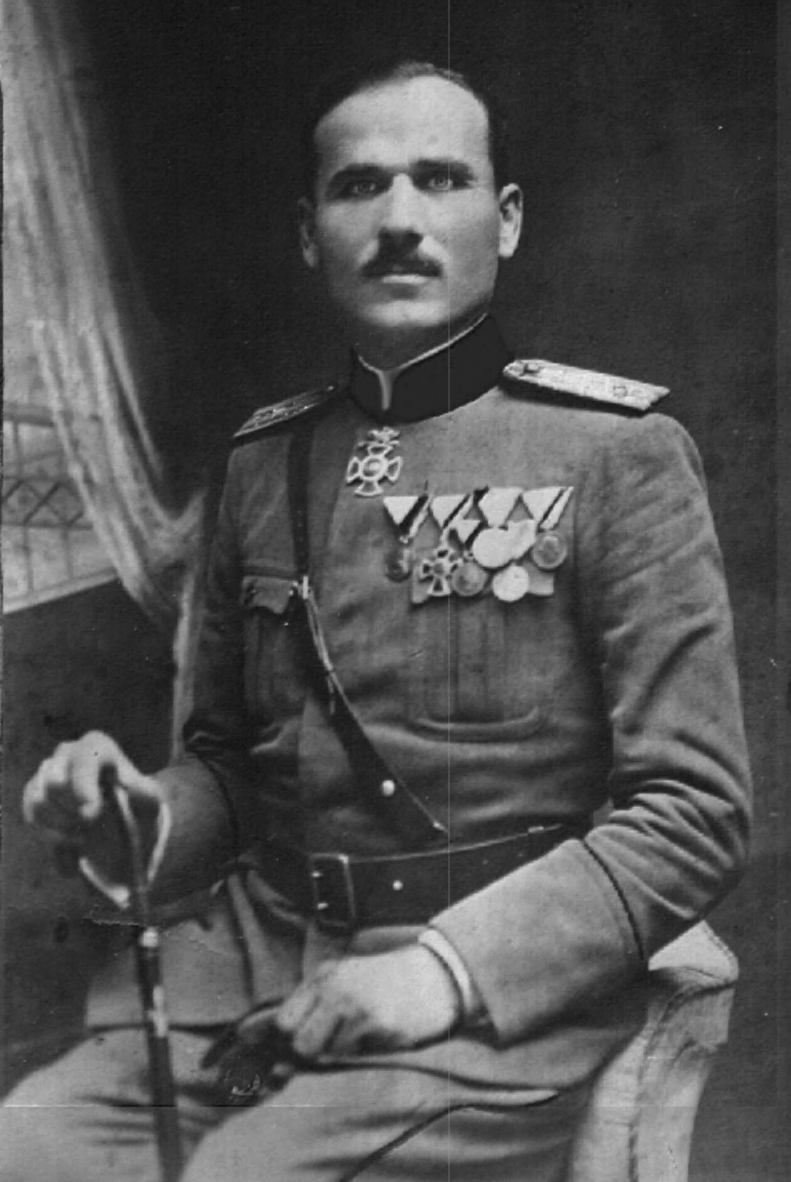
Photo of Krsto Popovic, the leader of the Christmas Uprising:
The Controversial Union with Serbia

Far from becoming an independent state again, Montenegro at the end of the war was occupied by the Serbian troops. With the Corfu Declaration of July 20, 1917, the head of the Serbian government Nikola Pašić and the leader of the Yugoslav Committee Ante Trumbić had already laid the basis of the Yugoslav union. The unification of the South Slavic territories with the Kingdom of Serbia was agreed by Pašić, some members of the Skupština, the representatives of the National Council of Zagreb and those of the Yugoslav Committee with the Geneva Convention of November 9, 1918.

With the occupation of Montenegro by the Allied troops –French, British, American and Italian– in the autumn of 1918 most of the country went under the control of the Serbian troops of Colonel Dragutin Milutinović, that presented themselves as the redeemers of the “oppressed brothers” and were actively engaged in propagating the union between Montenegro and Serbia. The unification was supported by relevant Montenegrin personalities such as Andrija Radović, head of the government in exile until January 1917. The split between Radović and King Nikola had lasted since August 1916, when the prime minister of Montenegro started supporting the union of Serbia and Montenegro through the unification of the Petrović-Njegoš and Karađorđević dynasties, firstly with the abdication of the former in favor of Alexander of Serbia, and then with a following rotation tothe throne between the two families.

Since February 1917, Radović was leading the Montenegrin Committee for the National Unifica-tion, founded in Geneva and in close contact with the Serbian governmental circles that worked to de-legitimize the sovereignty of King Nikola over Montenegro.At this point, the Montenegrin sovereign, mainly due to the marriage of his daughter Elena with the King of Italy Vittorio Emanuele III, hoped that the Italian occupation of Kotor and Bar could counterbalance the Serbian one and in some way be useful for the preservation of his dynasty on the throne of Montenegro. The Italian ambitions on the other side of the Adriatic Sea, a mix of political, strategic and economic aspirations, at least were the best guarantee for the maintenance of Montenegrin independence. At a political level, however, the Serbian Prime Minister Pašić worked to legalize the Serbian hegemony over the territory of Montenegro, preventing the return of King Nikola to the country, dissuaded also by the Italian and French governments.

At the same time, the committee led byRadović began the campaign for the election of the deputies to theGreat National Assembly in Podgorica, which would decide on the future status of Montenegro. On November 19, 1918, the Montenegrin elections held under the military pressure of the Serbian troops were done by acclamation rather than secret vote. Cetinje was the center of political propaganda: here the supporters of the unconditioned union with Serbia presented a list of candidates on a white colored paper, while their opponents, more cautious and with the aim to preserve the political integrity of Montenegro, presented a green colored list.

The two colors became the terms used to identify the two factions: the “whites”(bjelaši) were favorable to the union with Serbia, and the “greens”(zelenaši) were the supporters of independence. If the latter were pri-marily an expression of the rural society, the former had among theirranks more urban exponents: merchants, artisans, and intellectuals.

The Inter-Allied Occupation and the "Christmas Uprising"

According to the Italian military authorities in Montenegro, from the end of December 1918 there were rumors that in order to provide for the shortage of armament the Italian garrisons of Virpazar and Bar could be attacked both by pro-Serbian armed movements and Montenegrin independence supporters. This was the premise of the anti-Serb uprising that began in the surroundings of Cetinje on January 3, 1919. Jovan Simonov Plamenac and the other “green” leaders sent emissaries to the Inter-Allied command of Cattaro, led by the French General Venel, to demand the occupation of Cetinje and Montenegro by the Inter-Allied troops with the exclusion of the Serbian-Yugoslav ones.

Even in Bar the goal of the insurgents was to throwout the pro-Serbian local authorities. For Venel, however, any kind of Inter-Allied intervention against the Serbian-Yugoslav troops wasout of discussion. As in the previous days, the French general in charge did not even consult the commanders of the other Alliedcontingents. The French seemed deliberately favoring the Serbian occupation, openly supporting Radović and the “white” faction inthe area between Virpazar and Shkodër and facilitating the arrival rom Dubrovnik of a pro-Serbian Montenegrin legion trained and supported by the French.

The Italian military command in Montenegro openly denounced the pro-Serbian attitude of the French, an accusation that was considered reliable also by the American Ambassador in Rome Nelson Page, who on January 9 reported to the Commission to Negotiate Peace in Paris the text of a telegram from Kotor which stated:

........"January 6: French General is making a French-Serbian penetration into Montenegro admitting no other than Serbian authority. The intervention of his troops has a counterrevolutionary character. There are about 3,000 of which 500 were landed at Ragusa, 400 of the latter having already arrived at Cattaro [Kotor] have gone into Montenegro in French uniforms and with Serbo-French officers. Immediate help and energetic diplomatic steps indispensable since the enemy is energetically stirring up sedition.".......

Even the Montenegrin government in exile condemned how the French authorities facilitated the arrival in Montenegro of the followers of Radović, at the same time hindering the arrival of King Nikola’s supporters to whom had been denied the permission to enter the country with trivial excuses.

The Italians suspected that even the health precautions taken by the French in Kotor against typhoid cases in late December –communication between the city and the rest of Montenegro was limited with a release of a safe-conduct forleaving the country– were a pretext in order to allow to the Serbian commands to isolate the Montenegrin population. Pero Šoć denounced this attempt by the Serbian authorities to the American chargè d’affaires in France Bliss. According to Šoć only Serbian conspirators and agents had open access to Montenegro, while Montenegrin statesmen and politicians had to appeal to the Allies in order to have the permission to leave the country and reach Rome or Paris.

For this reason, the Italian general accused the French command of complicity in the subjugation of the Montenegrin population perpetrated by the Serbian authorities. Even without the support of the Inter-Allied authorities, Montenegrin insurgents under the command of Krsto Popovic (around 15,000-20,000 persons in the whole country) marched on Cetinje and other cities (Nikšić, Virpazar, Podgorica) facing Serbian-Yugoslav troops (January 6), which had a smaller number of men but were better equipped. Lacking food and ammunition, military preparation, skills and resolute leaders, around 3,500 “greens,” of which only a third were armed, were soon forced to desist from taking Cetinje, the only city where for a few days the insurgents could engage into a real battle against the Serbian-Yugoslav soldiers (400 men) and the “white” militias (300 men) under the command of the Serbian general Martinović.

Although they had the support of the population who were opposed to the violence of the “whites” and to the unconditional union of Montenegro with Serbia carried out in terms of a simple annexation, the “greens” did not prove to be as organized and cohesive as their opponents and the Serbian-Yugoslav soldiers were. The goal of the “green” armed insurrection was mainly to provoke an Allied intervention, and in particular an Italian one also if they had never explicitly affirmed it; it was not a real movement of resistance. The neutral position of the Italian troops, from which the insurgents expected a more or less direct support, diminished the hope of the “greens” for a success.

After the failed rebellion, despite the assurances given by Venel, the Serbs launched retaliation. Only in Podgorica they arrested 164 persons, including three cousins of King Nikola, eighty officers and numerous dignitaries of the court, confiscating properties.

The conflict between the “greens” and “whites,” however, did not end with the uprising of January 1919 and continued in the following years. The Italian military authorities, in the areas under their occupation, recorded incidents and violence between the “whites” and the Serbian-Yugoslav troops on the one side and Montenegrin nationalist gangs on the other. In early June, for example, the Italian High Command and the Italian Ministry of Foreign Affairs received reports about clashes in the mountainous region of the Shkodër frontier (Skadarska Krajina, Krajë for the Albanians) between the Serbian-Yugoslav troops and the Montenegrin "Komiti" headed by the well-known Savo Raspopović, on whose head the Serbian authorities placed a bounty of 20,000 dinars. Only in the evening of May 27, the assault of the bands of Raspopović caused to the Serbian-Yugoslavs several causalities. During the month, Raspopović continued his attacks in the area around Bar, a fact that brought the Serbian-Yugo-slav troops to accuse the Italians of having reached an agreement with the Montenegrin leader.

At the same time, Italian soldiers had to face frequent clashes with the Serbian-Yugoslav units and militias, which often ended in gun-fight for not entirely clear reasons.

The head of the Italian Army General Staff also insinuated that the French command in Albania and Montenegro could be responsible for many of the increasingly frequent anti-Italian demonstrations in the country. The Italian Foreign Minister Tommaso Tittoni promised to bring to the attention ofthe Allied governments the attitude of the Serbian-Yugoslavs, who claimed at all costs that Italian troops should abandon Montenegro.

The garrisons in the country, including the Italian detachments, were abandoned by the Allied troops at the end of April 1919. The Allied occupation was reduced to the coastal area (Bar, Kotor, Ulcinj and Virpazar) withthe aim of securing the supplies for Shkodër, while the inner part of the country was garrisoned exclusively by the Serbian-Yugoslav troops. The English also left Virpazar and Bar between April 27 and 30. The Italians remained in Bar (at the railways and the port), Ko\tor and Virpazar and were categorically ordered not to be meddle inthe clashes between Serbian and Montenegrin “dissident” bands.

From the summer of 1919 indeed the “greens” again took up the arms, this time with the Italian support. In April, in fact, the government in Rome with the Montenegrin government in exile signed a military convention for the formation of a Montenegrin legion in Italy. The Italian ships landed in Montenegro with new forces ready to incite the population against the Serbian authorities without reaching the desired results. The regions of Bar and Virpazar became theaters of new conflicts between Serbian-Yugoslavs, Montenegrin rebels and Italian troops.

The Yugoslav delegation at the Paris Peace Conference, indeed, once again explicitly asked for the evacuation of the Italian troops from Montenegro to definitely complete the unification of the Kingdom of Yugoslavia. In the summer of 1919, Radović (July 26-29) and then Pašić (August 14, 29 and 31) sent notes to the french Clemenceau calling for the withdrawal of the Italian troops that were accused of intentionally encouraging “the elements of disorder” in Montenegro.

Flags of the Green montenegrins while in exile in Gaeta (Italy):
Conclusions

At the end of 1919, at the Paris Peace Conference, the Yugoslav delegation –as during the summer the Italian counterpart had already done– officially denounced a series of violence that the Italian command in Montenegro committed against the Yugoslav soldiers and civilians and for which a special committee was appointed by the government of Belgrade for investigation. On the other hand, the Allies communicated to the Montenegrin government in exile that they no longer would anticipate the monthly credit hitherto paid to King Nikola (the subsidies ceased at the end of October).

In this way, King Nikola was forced to leave Paris and to reach Prince anilo, while the Montenegrin government in exile had to reduce its personnel, leaving in Neuilly sur Seine only Plamenac and other few persons. In this situation, despite the hostility of the Montenegrin population to the Serbian annexation, which, as it had already been said, did not mean an opposition to a real Yugoslav federalist union, or the Montenegrin establishment in exile it was impossible to continue to support the historical rights of Montenegro for independence.

Among other things, Plamenac tried a series of desperate and unsuccessful initiatives, such as the agreement concluded on May 12, 1920, with Gabriele D’Annunzio, who was still in Fiume with his legionaries, hoping to keep some kind of Italian support for the Montenegrin issue. At that time, in fact, the Italian government for the resolution of the Adriatic question had already abandoned the previous political radicalism and was now ready to reach an agreement with the government of Belgrade. The agreement of Plamenac and D’Annunzio, with the latter that was keeping contacts with the representatives of the Yugoslav nationalities that opposed Belgrade centralism in the Kingdom of Yugoslavia, provided for the restoration of the independence of the Montenegrin kingdom as a first step towards the liberation of the Yugoslav populations from the Serbian rule.

The Supreme Council of the Allies briefly examined only a Mon-tenegrin note sent on November 26, 1919, with which Plamenac threatened that if the Montenegrin delegate was not immediately invited to the Peace Conference for the signing of the peace treaties with Germany, Austria and Bulgaria, the Montenegrin government in exile would conclude a separate peace with these countries.

On December 1, 1919, the Supreme Council decided not to give any response to the threats of Plamenac, simply ignoring his letter. The Italian delegate De Martino agreed with the decision, but also asked if the Supreme Council before or later would take into consideration the Montenegrin issue, which still needed a solution. For Clemenceau the Montenegrin issue did not exist, the problem –he replied to De Martino– was more over different: For how long did the Italian government still have the intention to pursue this matter? Clemenceau, without explicitly stating it, was reaffirming that for the Allies the Montenegrin issue had been resolved long time ago with the proclamation of the Kingdom of Yugoslavia.

he Montenegrin issue, from the diplomatic point of view, was officially over at the end of 1920, when also the appeals of the Montenegrin government in exile to the League of Nations did not find an answer (November 1920).

Italy, which had been the main supporter of the Montenegrin cause in order to defend its interests on the other coast of the Adriatic Sea against the Yugoslav aspirations, finally interrupted the political and military support to the Montenegrin refugees preferring an agreement with the Kingdom of Yugoslavia for the definition of the border dispute and other controversial issues. The signing of the Treaty of Rapallo, in November 1920, meant the definitive end of the Montenegrin issue and the legitimacy of the Yugoslav state for the country that had opposed the most its recognition in the international context.

After the apparent settlement of the Adriatic issue and of the Italian-Yugoslav relations, also France took the moment to resolve itsrelations with the Montenegrin king (on December 20, 1920).

Even for Great Britain, which still during the summer of 1920 had refused to recognize the annexation of Montenegro as a fait accompli – Vesnić, head of the government in Belgrade, was insisting on this argument for the formal recognition of the union of Montenegro with the Kingdom SHS– the opportunity for the Montenegrin people to send “freely elected representatives to the Yugoslav Constituent Assembly” represented the best recognition of the legitimacy of the unification.

All this facts were followed by the interruption of diplomatic relations between the Montenegrin government in exile –that in the meantime was moved to Rome– and the United States and Great Britain respectively on January 21 and March 17, 1921: it was substantially the conclusion of the vain struggle for the independence of Montenegro against the unconditional union with Serbia and the final acceptance of its incorporation into the Kingdom of Yugoslavia.

Further readings

1-Montenegro italiano (1941-1943): https://www.academia.edu/6469238/le_nuove_province
2-Occupazione italiana dell'Adriatico dalmato nel 1918: https://www.eastjournal.net/archives/126261

Sunday, September 4, 2022

ITALIAN CATTARO (ACTUAL KOTOR IN MONTENEGRO)

In the south of coastal Dalmatia there it is a city that has a history closely linked to Italy: Cattaro, the actual "Kotor" (former capital of Montenegro). Indeed Cattaro -after being under the Republic of Venice for many centuries- has been "italian" two times in the last two centuries: in the napoleonic kingdom of Italy (1805-1810) and during WW2 (1941-1943). The following is an essay I have written in 2018 and that has been published -partially- on the english, spanish & italian wikipedia:

HISTORY OF "CATTARO" (actual Kotor, the main city of Montenegro)

Cattaro (or Venetian Cattaro, called in Italian "Cattaro la Veneziana") was the historical city populated by autochtonous "romanised" Dalmatians since the fall of the Roman empire and that belonged to the Republic of Venice for nearly five centuries until Napoleon times (for further info, please read my https://researchomnia.blogspot.com/2013/09/dalmatias-neolatin-city-states.html).

Later it was part of the Napoleonic kingdom of Italy until was added to the Austrian empire in the XIX century and started to lose the neolatin characteristics, while becoming a Montenegrin city called "Kotor" actually. However in 1941 the city was united for a few years to the Kingdom of Italy in the "Governorate of Dalmatia".

History

Ascrivium, or Ascruvium, the modern Cattaro, was first historically mentioned when submitted to Rome in 168 BC.

The "Dalmatian city-states", with own neolatin dialects (the main where in Veglia and Ragusa), showing Cattaro in southern Dalmatia

Roman emperor Justinian built a fortress above Ascrivium in AD 535, after expelling the Goths. The city had around 5000 inhabitants in that century.

A second town probably grew up on the heights around it, because Constantine Porphyrogenitus -in the 10th century- alluded to a "Lower Cattaro". The city suffered the barbarian invasions of the Avars and Slavs, but survived with the autochtonous romanised population greatly diminished to a few hundred inhabitants.

Cattaro was one of the more influential Dalmatian city-states of romanized Illyrians throughout the Middle Ages, and until the 11th century the Dalmatian language was spoken by the inhabitants of the city. Later, with the Venetian domination the inhabitants started to speak the "Veneto da mar" instead of the old Dalmatian language (until the XIX century, when the main language started to be the Montenegrin).

The city was plundered by the Saracens in 840 AD, and a few centuries later by the Bulgarians in 1102 AD. In the next year it was ceded to Serbia by the Bulgarian tsar Samuel, but revolted, in alliance with Ragusa, and only submitted in 1184 AD, as a protected state, preserving intact its republican institutions, and its right to conclude treaties and engage in war. It was already an "Episcopal See", and, in the 13th century, Dominican and Franciscan monasteries were established to check the spread of Bogomilism.

In the 14th century the commerce of Cattaro rivalled that of Ragusa, and provoked the jealousy of Venice. The downfall of Serbia in 1389 left the city without a guardian, and, after being seized and abandoned by Venice and Hungary in turn, it passed under Venetian rule in 1420. Since then, for nearly five centuries the city was called "Cattaro la Veneziana" (the venetian Cattaro), because it was a city fully Italian in architecture and literature and the majority of the inhabitants spoke the "Veneto da mar" Italian dialect (very similar to the one spoken in Istria). Cattaro in those centuries enjoyed a huge development and was the main city and capital of the "Albania Veneta".

Venetian Cattaro was a catholic city, with the territory of the Diocese that even today corresponds to that of the historical region Albania Veneta since 1571. Cattaro was the most eastern city of Catholicism in the Balkans dominated by the Ottomans: it was the symbol of western society successfully facing Muslim attacks in those centuries.

However it was besieged by the Turks in 1538 and 1657 but saved by the venetian fleet; visited by plague in 1572 and nearly destroyed by earthquakes in 1563 and 1667.

The Republic of Venice reconstructed Cattaro after the terrible earthquake of 1667 (https://www.total-montenegro-news.com/lifestyle/1247-italy-invests-in-its-cultural-heritage-in-boka-bay).

By the Treaty of Campoformio in 1797 it passed to Austria; but in 1805 -by the treaty of Pressburg- Cattaro was assigned to the kingdom of Italy (1) and later was united in 1810 with the first French Empire.


Venetian Maritime Gate in the Cattaro city-walls


Napoleon included Cattaro between 1805 and 1810 in his "Napoleonic Kingdom of Italy". and made a decree establishing the use of the Italian language in schools throughout Dalmatia.

Cattaro was nearly fully venetian speaking in those years

In 1814 the city was restored to Austria by the Congress of Vienna, but the Italian language remained the official language (with German). After that year some slavs started to settle in the city from the surrounding territories.

The Cattaro population in 1848 showed strong support toward Venice and the early Italian Risorgimento:

When was informed of the Austrian concession to a "free" Constitution, on March 23, 1848, the Cattaro population poured into the streets acclaiming to Italy while on the same day the municipality voted for union with Venice. The "Vladika" (ruler) of Montenegro, worried about these upheavals, spoke against the people of Cattaro ( and of the Ragusa people - even if Austrian citizens) stating that if any other exaltation for the Italian revolution had been demonstrated he would reduce "to ash" and sprinkle "blood" in the whole southern Dalmatia. At the same time he sent a battalion which, with arms, removed the possibility that the initial uprising was transformed into a real insurrection. The inhabitants of Cattaro, however, continued to follow the events of the Italian Risorgimento: among the original "Mille", who with Garibaldi sailed from Quarto to Sicily to unify southern Italy to the Kingdom of Italy , there was also Marco Cossovich, a native of Venice but from a Cattaro family .

During the XIX century, Cattaro was the chief town of an administrative district in austrian southern Dalmatia. Cattaro occupied a narrow ledge between the Montenegrin Mountains and the "Bocche di Cattaro", a winding and beautiful inlet of the Adriatic Sea. This inlet expands into five broad gulfs, united by narrower channels, and forms one of the finest natural harbours in Europe.

Teodo, on the outermost gulf, is a small naval port. In the first years of the 20th century, Cattaro was strongly fortified, and about 3000 troops were stationed in its neighborhood.

On the seaward side, the defensive works included Castelnuovo (actual Erceg Novi), which guarded the main entrance to the Bocche. On the landward side, the long walls running from the town to the castle of San Giovanni, far above, formed a striking feature in the landscape; and the heights of the "Crevoscia", a group of barren mountains between Montenegro, Herzegovina, and the sea, were crowned by small forts.

Venetian symbol on Cattaro's venetian walls

There were many interesting places on the shores of the Bocche. Castelnuovo was a picturesque town, with a dismantled 14th century citadel, which has, at various times, been occupied by Bosnians, Turks, Venetians, Spaniards, Russians, French, English and Austrians.

The orthodox convent of St. Sava, standing amid beautiful gardens, was founded in the 16th century, and contained many fine specimens of 17th century silversmith work. There was a Benedictine monastery on a small island opposite to Perasto (Perast), eight miles east of Castelnuovo. Perasto itself was for a time an independent state in the 14th century. Rhizon, the modern hamlet of Risano, close by, was a thriving Illyrian city as early as 229 BC, and gave its name to the Bocche, then known as Rhizonicus Sinus (2).

In the second half of the XIX century the slav nationalism erased nearly all the venetian-Italian presence in the city, that was called officially Kotor after WWI. However in the early 1900 census there were some hundreds of Italians still living in Austrian Cattaro: they were less than 2% of the inhabitants.

Italian irredentism of Cattaro was supported and promoted by Fascism in the late 1930s. As a consequence when Italy (with Germany) defeated Yugoslavia in 1941, between 1941 and 1943 the Kingdom of Italy annexed the area of Yugoslavian Kotor - which became one of three provinces (with the official name: "Regia Provincia di Cattaro") of the Italian "Governorate of Dalmatia" and that had an total area of 4801 km2 with a population of 380,100 (3).

It is noteworthy to pinpoint that the Queen of Italy in those years was Elena (daughter of the king Nicholas I of Montenegro): she supported the union of the Cattaro region to Italy and personally "protected" the city's citizens.


Under Italy, the province of Cattaro (subdivided in 15 "Comuni") had an area of 547 Km2 and a population of 39,800 inhabitants. Most of the province's inhabitants were Serbs (mostly Orthodox and some Roman Catholics), and there were 350 Dalmatian Italians, concentrated in Cattaro and Perasto (now Perast). The only official language in Cattaro was the Italian and all the schools were in Italian language. The Italian government did many works in these few years, like the improvement of sewage, roads and hospitals.

After September 1943 the Germans occupied the city and consequently started a continuous reduction of the Italian presence in Cattaro (that after 1945 was only called "Kotor" under Tito's communist rule)

Actually the Italian Community of Kotor (Comunità Italiana di Cattaro), in the city of Kotor is being registered officially (with the "Unione Italiana") as the Italian Community of Montenegro (Comunità degli Italiani del Montenegro) and is enjoying a huge success (4). In connection with this registration, the "Center for Dalmatian Cultural Research" (Centro di Ricerche Culturali Dalmate) has opened in 2007 the Venetian house in Cattaro to celebrate the Venetian heritage in coastal Montenegro (5).

Venetian Architecture

More than four centuries of Venetian domination have given the city of Cattaro the typical Venetian architecture, that contributed to make actual Kotor a UNESCO world heritage site (6).

Cattaro's Venetian Walls

These are the most important structures & buildings in venetian style:

1) The Republic of Venice left in Cattaro the magnificent "Venetian Walls" surrounding the historical section of the city. The Venetian fortification system, which protects the city from the sea, is actually a wall 4.5 km long, 20 m high and 15 m wide, and is preserved as one of the most important architectural masterpieces in Montenegro.

The construction of the ramparts were built and rebuilt up to the 18th century. The oldest town gate of Cattaro, of the three existing in the town, is the “South” gate which was partially constructed in the 9th century. The “North” and the “Main” gates were built in the Renaissance style by the first half of the 16th century.

2) The most representative monument of Roman architecture in the Adriatic Montenegro is the magnificent "Cathedral of Saint Tryphon", constructed in 1166 and built on the remains of a former Catholic temple from the 9th century. There are the remains of the frescos from the 14th century and the valuable treasury with domestic and Venetian golden works dating from the 14th to the 20th century.

3) Besides the Cathedral, in the heart of the old town, there are magnificent examples of sacral venetian architecture originating from 12th till 20th century:
A-The Romanic church of St. Lucas was built in 1195, while the Romanic church of St. Ana dates from the end of the 12th century and has frescos dating back from the 15th century.
B-The Romanic church of St. Mary dates from 1221. The church contains the remains of a monumental fresco painting as well as an early Christian baptistry.
C-The Gothic church of St. Mihovil was built on the remains of the Benediction monastery from the 7th century with frescos dating back from the 15th century.
D-St. Clara's church dates from the 14th century with the extremely beautiful marble altar, the work of Francesco Cabianca, from the 18th century.
E-The Church of Lady of Health originates from the 15th century.
The Orthodox Church of St. Nicolas was built by the beginning of the 20th century with a valuable collection of icons.

Old Cattaro's postcard, showing typical venetian architecture buildings and the famous "Clock Tower" built in the "Cinquecento" (XVI century).

4)There are also numerous palaces in venetian style in the actual "Kotor Stari Grad" (downtown Kotor). A few were built in the "Cinquecento" (XVI century) like the famous "Palazzo Pima", where was born the writer Bernardo Pima.

Pima Palace (XVI century)

Some of the most famous of these venetian-style palaces are:

The Drago palace with Gothic windows from the 15th century; the Bisanti palace from the 17th century; the Pima palace, with typical Venetian renaissance and baroque forms from the 16th century; the Pasquali palace from the 16th century; the Grubonia palace with the built-in emblem of the old Cattaro's pharmacy established in 1326; the Gregurina palace, from the 17th century, which today contains the Naval museum, and finally the Clock tower, from the 16th century, with the medieval pillory just beside it.

Additionally, in those centuries Italian Renaissance literature enjoyed a huge development in Cattaro: the most famous writers (often writing in Italian language) were Bernardo Pima, Nicola Chierlo, Luca Bisanti, Alberto de Gliricis, Domenico and Vincenzo Burchia, Vincenzo Ceci, Antonio Zambella and Francesco Morandi.

There have also been notable Italian-language writers in the 15th to the 18th century who originated from Venetian Albania and lived in the region capital Cattaro, notably Giovanni Bona Boliris, Cristoforo Ivanovich and Ludovico Pasquali.

The Cattaro area is home to numerous tourist sights in the surroundings: St George Island (Sveti Đorđe) and Our Lady of the Rocks islets off the coast of Perasto are also among the more popular destinations in the vicinity. The island of St. George contains the famous Saint George Benedictine monastery from the 12th century and an old graveyard for the old neolatin nobility from Perast and Cattaro.

Notes

1) Map showing Cattaro inside the Kingdom of Italy of Napoleon: https://digilander.libero.it/arup/istriaNapo.html
2) Rhizon submitted to Rome in 168 BC
3) Rodogno, Davide (2003). Il nuovo ordine mediterraneo. Turin: Bollati Boringhieri
4) Comunita' italiani di Cattaro/Montenegro:https://www.comunitamontenegro.org/it/aktivnosti/
5) Photos of Cattaro and other cities of Venetian Albania, with article "Il Veneto nel Cattaro" (in Italian): http://www.letrevenezie.net/pubblicazioni/Veneto%20Cattaro/art-03.htm
6) UNESCO's historical and cultural Region of Cattaro (actual Kotor):https://whc.unesco.org/en/list/125

Monday, August 1, 2022

NEW VILLAGES IN 1940 ITALIAN LIBYA

Maps with the location of the 26 villages (above: Tripolitania; bottom: Cirenaica; villages created in 1938 (in blue) and in 1939 (in red). In orange are the first four created in 1934 in Cirenaica)

THE NEW 26 ITALIAN VILLAGES CREATED IN 1938-1940 LIBYA

Italo Balbo as Governor of Italian Libya promoted a demographic colonization of the coastal areas of this colony by Italian families. Starting from 1938, he planned to relocate in just five years 100,000 Italians in a group of newly created farm villages: in early 1940 nearly 30,000 Italians were living in 26 agricultural villages of Tripolitania and Cirenaica. The beginnings of this colonization project were economically positive, but WW2 destroyed it all: by January 1943 the Allies had conquered all Italian Libya and the villages were mostly damaged & sometimes abandoned. A few survived with some Italian colonists until the late 1960s, but in worsening conditions (see the following video of Village Crispi in the 1950s:).

For a detailed & complete study with related photos, please read in Italian:https://njema.weebly.com/uploads/6/3/4/5/6345478/vittoria_capresi_-_i_centri_rurali_di_fondazione_libici_tesi_di_laurea.pdf

In 1938 more than 20,000 Italian farmers went to Libya and 26 agricultural villages were created for them: Olivetti, Bianchi, Giordani, Micca, Tazzoli, Breviglieri, Marconi, Garabulli, Crispi, Corradini, Garibaldi, Littoriano, Castel Benito, Filzi, Baracca, Maddalena, Aro, Oberdan, D'Annunzio, Razza, Mameli, Battisti, Berta, Luigi di Savoia, Gioda.

Ten other Libyan villages, in which Berbers and natives learned from Italian farmers to make money from their land with modern agriculture, were : El Fager (Alba), Nahina (Deliziosa), Azizia (Perfumed), Nahiba (Risorta), Mansura (Vittoriosa), Chadra (Green), Zahara (Fiorita), Gedina (New), Mamhura (Fiorente), El Beida (la Bianca) already named "Beda Littoria." All these ten villages had their mosque, school, social center (with gymnasium and cinema) and a small hospital, representing an absolute novelty for the Arab world of North Africa.

Indeed in this operation of Italian demographic colonization there was a unique and revolutionary novelty: the Italian government of Italo Balbo did not treat the native Libyan population as an "inferior race" (like did the French and British in their African colonies) to be exploited but, having recognized them Italian citizenship in the so called "Fourth Shore" of Italy, reserved the same treatment as the Italian nationals. So, farms to be cultivated were distributed to the Libyans (as well as to the Italians) and also for them were built some Libyan rural villages. All those ten villages were still inhabited and growing as agricultural centers in the independent Libya after WW2.

The agricultural village "Bianchi" -near Tripoli- when inaugurated in 1938 and showing the trees just planted

The following are excerpts translated from an essay written by Marco Piraino about these new villages (https://webcache.googleusercontent.com/search?q=cache:xPysHxJqUwkJ:https://www.revistalarazonhistorica.com/31-10/+&cd=33&hl=it&ct=clnk&gl=us ) and titled in Italian: "L’ITALIA FASCISTA E LA COLONIZZAZIONE DEMOGRAFICA DELLA LIBIA: premesse, sviluppi e conclusione di un progetto politico-sociale totalitario.

FASCIST ITALY AND THE DEMOGRAPHIC COLONIZATION OF LIBYA

The project (of Libya's colonization by 30000 Italian farmers) was officially launched on May 17, 1938 with the Royal Decree Law No. 701, which specified, among other things, the urgent and absolute need to adopt extraordinary measures to support demographic colonization. It involved the totality of the components present in the colonial society, with the precise purpose of achieving a substantial balance between the metropolitan and the Arab population, taking into account the demographic relationship unfavorable to the Italians, in favor of whom the program provided for the reception of forty thousand new settlers in two years (in fact they went down later to thirty thousand), a prelude to a much more ambitious goal that counted on being able to install a population for the middle of the century whose total number would have been about five hundred thousand metropolitan. Balbo so ... announces the great project in May 1938 and six months later the first twenty thousand settlers land in Libya. In just six months, mobilizing 10,000 Italian workers and 23,000 Libyans, the two colonizing bodies, under the energetic leadership of Balbo, build dozens of rural villages and hundreds of farmhouses, roads and aqueducts, while they provide for the delimitation of 1800 new farms . Each farm, painted in white and with simple architecture, is equipped with: a) a farmhouse composed of a dining room, three bedrooms and a bathroom; b) a barn behind, separated from the house, and a warehouse. The barn can accommodate four working beasts and has a concimaia attached; c) a well of the first aquifer and a cistern to collect rainwater.

Obviously, the main task of the central government, assisted by that of the colony, was to choose, transport and arrange hundreds of families on previously set-up farms, all naturally at the expense of the treasury. This policy harmonized with the fascist ideal of a beneficial totalitarian state, the bearer of order, discipline and prosperity in the lives of its most humble citizens. However, the selection of the first wave of settlers had not proved to be a simple task, occupying for three months special medical committees chosen for the occasion which examined 6,000 families who had applied for admission to the colonization program. The selection was made in three months by three itinerant Commissions, appointed by the Commissariat for migration and colonization, made up of agricultural, sanitary and administrative technicians. The average composition of the 1,800 families (1,000 are allocated in Tripolitania and 800 in Cyrenaica) is 9.01, that is three male work units, two or three female units and the rest boys from three to 15 years [...]. The colonial families are supplied by 750 municipalities and come mostly from the Veneto, from Emilia, from the Lombard provinces of Mantua, Brescia and Bergamo, from the Abruzzi, from Puglia, from Calabria and from Sicily. The Commissariat that organizes large departures has arranged for one companion for every twenty families, who will direct them from their place of origin to the houses to each of them destined for Tripolitania and Cyrenaica [...].

The families are thus divided into the various villages: Tripolitania (National Fascist Institute of Social Security): 100 families at Oliveti, 75 at Bianchi, 111 at Giordani, 120 at Tarhuna; (Body for the Colonization of Libya): 37 at Oliveti, 320 at Crispi, 100 at Gioda, 110 at Breviglieri and 21 at the Azizia. Cyrenaica: 176 to the Barca [Barce], 210 to the Oberdan, 60 to the D'Annunzio, 120 to the Battisti, 39 to the Zorda, 81 to the Maddalena, 25 to the Race, 40 to the Deda [Beda], 35 to the Slonta, 15 to the Faidia , 66 to the Savoia [Luigi di Savoia], 35 to the Berta [...]. Subsequently the imposing program of demographic colonization will have new developments and the work of high civilization realized by the Regime will contribute effectively to the attainment of the economic autarchy of the Nation.

Village "Oliveti" in Tripolitania, surrounded by farm houses

Plans

The plans for logistics, organization and the transfer of settlers, in both migrations planned for the two-year period 1938-1939, were carried out punctually, with departures scheduled every year on the 28th October, the anniversary of the "March on Rome" , thus bringing about thirty thousand metropolitans to the coasts of Libya, who were placed on specially cleared state lands. The farmers were welcomed in the villages and colonization areas mostly developed along the coastal road by I.N.F.P.S. and from the E.C.L. that, assisted by the technical services of the government and the colonization offices, had supervised the completion of all the infrastructures and the development of land reclamation despite having a very short period, also setting up the enlargement of arable land in agricultural areas chosen in precedence and exploitation of new areas in view of the growing number of incoming "new Libyans". The two bodies, following now the established practice in previous years, planned the regular subdivision of the land into small lots, providing as usual the assistance of the settlers in the cultivation of their farms, after the latter had naturally been placed in their new homes equipped with of the necessary reserves. The total amount of the amount that was paid by the State for this plan was calculated at 945 million lire, of which 321 were destined for major general development works carried out directly by the government, including hydraulic works consisting of 2 large aqueducts and 35 artesian wells with related annexed structures. In addition, 250 kilometers of roads would have been built with the related communication lines, as well as the first nuclei of 20 new agricultural villages. A quota of 380 million was instead allocated to the construction of rural houses and the arrangement of agricultural land transformed from steppes into arable land. The remaining sum should have covered the technical organization of the operation and the contributions provided for the reclamation law, which should have been paid by the State in the first two years of the operation.

Overall, on the death of Balbo, which occurred on June 28, 1940, eighteen days after Italy entered the war in the Second World War, the work of corroborating the Libyan territories exceeded 200,000 hectares between private companies and official colonization. . In Cyrenaica, ten villages had sprung up, as well as various concessions and private companies, with 2755 families (over 10.000 members). Seven villages built in Tripolitania by the Tripolitania Colonization Agency at Misurata, Azizia and Tarhuna and nine others built by the National Institute of Social Welfare, without counting the private concessions and those of the Italian tobacco company at Garian which welcomed 3960 families with 23.919 members. The pertinent reclamation plan concerning the Italian demographic colonization in the years 1938-39 would have covered an area of ​​approximately 133,000 hectares divided in turn into lands extended from 15 to 50 hectares, with relative annexed farm, all due to the availability of water that of the type of cultivation.

As regards the measures taken in favor of the Arab population in the agricultural colonization program in the years 1939-1940, the Muslim villages of Zahra (Fiorita), el-Fager (L'Alba) and Chadra (Green ), Nahida (Risorta), Gedida (Nuova), Mansura (Vittoriosa); in Tripolitania the villages of Mahamura and Naima were inaugurated. 1,400 hectares of land were also destined to Libyan peasants, even if at the current state of research only 500 hectares are actually assigned, with plots whose size ranged from 2 to 10 hectares. Regarding the assignment of houses and land in these villages we have definite information only concerning 32 families residing in Alba and Fiorita, while in Mahamura we are aware of 100 farms occupied by as many families. However, it must be recognized that the set of the aforementioned measures could never be considered fully operational, both because of the initial mistrust of the native populations and, subsequently, of the impossibility of proceeding further in the complete realization of such plans due to the negative outcome the war had for the fascist Italy, with the invasion of 1941 and the integral integral occupation of Libya by the armies of the British commonwealth of 1943.

Conclusions

Italian colonists -with their belongings- approaching their farm village in Cyrenaica

In making a final judgment on the process of demographic colonization in Libya, the majority of historians have provided an overall negative balance of the story, minimizing the negative impact that the world war had on it and attributing the real failure of this project to the choices wrong strategic elaborated by the fascist regime well before the outbreak of hostilities with the allied powers, in this regard it is not unusual to come across statements like this: The reasoning later advanced by the apologists, for which the "demographic" colonization would be aborted only for the arrival of the war, it appears without foundation: the errors and failures were precedents, as evidenced by the frantic change of strategies in the space of a few years. A critical scholar noted that the high expenses of the regime and the poor results collected by the agrarian colonization of Libya, which moreover affected only a fraction of the Italian population residing in the colony, were "indicative only of the waste, of the investments and of the wrong choices" of fascism, rather than its efforts to enhance the Fourth side. There is no doubt that the Regime, also with regard to the colonial affair in question, in an attempt to gradually realize its own peculiar organizational political model, with Mussolini intent on acting as arbitrator in search of a substantial balance between the orientations expressed by the Fascist Party leaders, reflecting in this the internal dynamics of national politics, fluctuated, according to what we have observed, from an initial action to support the private initiative substantially of a liberal sign to a statist economic policy of the mold corporate-leadership, as can be clearly seen from the enormous effort made by the fascist state described in the previous pages and profused in the project of integrating the Libyan territories into the Italian political and economic circuit.

However, it is equally important to specify some data, particularly of a demographic and economic nature, to be contextualised in relation to a different perspective of analysis concerning the actual primary needs of the fascist government. Data that end up characterizing the modus operandi for an unquestionable primacy attributed to the ideological objectives of the totalitarian policy of the Regime, rather than to the opportunities and the real convenience suggested by the analysis of simple economic data referring to the concrete potentialities of the Libyan territory. Well, for what concerns the quantitative presence of Italians in Libya, the remarkable and consistent numerical growth of the so-called metropolitan is undoubtedly evident, whose population was more than quadrupled in less than two decades. In fact, from the 27,163 inhabitants present in 1921, the considerable figure of 128,264 inhabitants recorded in March 1940 was recorded, on the eve of Italy's entry into the war, a figure which we know was destined to grow for some time (at the end of 1940 there were 140,000 Italian civilians present on the "fourth shore" against 30,000 Israelites and 850,000 registered Libyans). An element which must necessarily be combined with the evident growth of the indigenous Muslim population compared to previous years. All phenomena of development that manifest the most significant demographic increase starting from the start of the direct management policy by the fascist State with the demographic colonization plans, significantly concomitant with the arrival in the colony of Governor Balbo and the inauguration of the great public Works. These works, with reference to the report presented by Minister Teruzzi at the end of November 1939, were so extensively illustrated: The complex of public works of the last two years is really important, above all due to the great amount of work required by the implementation of intensive demographic colonization plans.

To allow easy and rapid communication with the agricultural villages, numerous roadways have been and are being built across the colonization areas for a total length of about 380 km. Numerous tracks are connected to these roads. Of particular importance is the access road to the Ras Hilal landing, built with the same characteristics as the Libyan coast road and with a section running along the road tunnel that constitutes the access to the sea in most of the areas in the Cyrenaic Gebel. For the exploitation of the potassium salts of Marada and to facilitate the transport of the mineral to the coast from where it will be embarked for Italy a trunk of road is under construction [...] Recently the artificial road has been completed that crossing the Gefara [...] joins the port of Zuara with the territory of the Gebel Nefusa grafted into the Nalut roadway near Giosc. Several other local road trunks have been built and the vast network of tracks with natural bottoms has been improved and increased.

Among the aqueducts for the service of colonization, the importance of the Cyrenaic Gebel already in an advanced stage of construction, with a development of 198 Km, is of truly remarkable importance. of the capacity of 5000 cubic meters per day to all the colonization areas of the Gebel up to the most distant villages of Baracca and Filzi to the west of Barce. In western Libya, the aqueducts of Breviglieri and Marconi are of considerable importance. For the supply of drinking water in the main inhabited centers, considerable work has been carried out, including the development of the Benghazi water network and above all the completion of the Tripoli aqueduct, which today can have about 19,000 cubic meters of excellent second water per day groundwater. There are also numerous artesian wells and first and second aquifer wells excavated in colonization villages and private concessions. Particular care has been given to strengthening existing ports and creating new landings. In the port of Tripoli it was started in 1937 and a vast excavation program is being conducted at an accelerated pace so that it is now possible for the major transatlantic ships to enter the port and stand alongside the quay. Construction of new docks is also underway in order to increase the commercial potential of the port.

Villaggio "Oliveti" in 1939 Tripolitania

Expansion works are also underway in the port of Benghazi, a 160-meter-long reinforced concrete dock was built in Ras Hilal [...]. In addition to the schools included in the villages, another 28 school buildings sprang up in the various colonization areas, while new secondary primary schools were opened in Tripoli, Benghazi, Derna and Misurata, Italo-Arab schools in Jefren, Tauorga, Tigrinna, Zavia, Augila. The hospitals of Tripoli and Benghazi have now been completed and are now equipped with extremely modern hygiene and prophylaxis laboratories, and extension work is underway for those of Barce and Misurata. Of recent construction are the asylum for Muslims and the sanatorium of I.N.F.P.S. in Tripoli. The development of the major centers of the Fourth Shore in recent years has been truly remarkable. It will suffice to mention that in 4 years construction companies have increased by 20% with an increase in national workers employed of 300%. New important public buildings have sprung up and in relation to the ever-increasing building needs the new regulatory plans have been drawn up and approved, not only of the main urban centers, but also of many other smaller centers. Like -for example- in the nice village Oberdan.

An aerial photo of the village Oberdan in Cyrenaica, created in 1939

The complex of these results, according to the data reported so far, allows to establish how in reality the general picture of the colony was in full evolution and with concrete prospects for growth and improvement. An economic-demographic framework that we can define as encouraging. In such a context, just at the beginning of a phase of economic development and the resumption of demographic growth, the consequences and negative effects on the life of the colony that had the entry of fascist Italy in the world war in June 1940 should certainly be reconsidered. , beginning with the alteration of the normal daily rhythms of a territory that, it is good to not forget it, for the supplies depended almost totally on the connections with the Italian peninsula.

LINKS:

Photos "Archivio LUCE" of Italian Senate about Italian Villages inaugurations: http://senato.archivioluce.it/senato-luce/scheda/foto/IL0010034475/12/Gruppo-di-coloni-italiani-destinato-al-villaggio-rurale-Oliveti-si-prepara-a-salire-su-un-autocarro-nello-spiazzo-antistante-un-complesso-di-Magazzini-di-ordinaria-custodia.html

Video of Italian colonists moving to live in Village Crispi:


Video of arrival of the Italian colonists in Tripoli in 1938:


3 comments:

Nina Baker-January 5, 2020 at 2:13 AM Thanks for this fascinating insight into what seems to be an almost unknown aspect of 20th century fascist history. My dad was stationed at RAF Castel Benito in 1946 and lived in Garian, which he described as having more administration buildings than inhabitants and what few locals were still there were mainly nomadic arabs. Now I understand why there were all the buildings but no people.

Unknown-July 5, 2020 at 8:52 PM Today I live in villaggio Bianchi. My name is Muhannad

Unknown-July 5, 2020 at 8:55 PM +218910735172 Who has more information about Bianchi Village sends on Whatsapp

Tuesday, July 5, 2022

ROMANS IN POLAND (2)

As written in my last month issue the Romans reached what is now southern & central Poland as merchants using the "Amber route", but also as legionaries.

Indeed archeologists have recently done discoveries that confirm the military presence of the Romans in the area north of the Oder river (see https://www.thefirstnews.com/article/romans-roamed-the-kujawy-region-of-poland-new-discoveries#:~:text=An%20unprecedented%20discovery%20has%20for,than%20had%20previously%20been%20assumed.) and also near the village of Malawa near the border with Ucraine (see https://www.express.co.uk/news/science/1380625/ancient-coin-archaeology-roman-emperor-hadrian-denarius-poland-evg).

The "amber route" in Poland. The city of Kujamy is near Biskupin
Additionally it is noteworthy to pinpoint that also in the area od what is now southern-central Poland there are evidences of Roman military presence: numerous Roman military artifacts dating as far back as the 1st century A.D. have been unearthed in Kujawy, central Poland.

This is a region in the Vistula basin far outside the boundary of imperial Rome even at its greatest extent under Trajan in the early 2nd century.

According to historian Cassius Dio, Roman cavalry may have made in appearance in what is now Kujawy in the late 1st century, and it was the "Lugii" themselves who called this cavalry.

Around 91 AD, the german tribe of the "Lugii" (related also with the "Vandals") made an alliance with Rome and asked the emperor Domitian to send troops to aid in their fight against the "Suebi" tribe. Domitian agreed in a desultory fashion and sent a measly 100 horsemen. Dio does not mention them any further, so there’s no way to know if they arrived, fought, returned or anything else. The territory of the Lugii, as far it can be determined, seems to have extended further to the south of modern-day Kujawy, so even if the horsemen went to their aid as promised, they could well have been a long way away from the find site. If they did make it, they would be the first Roman soldiers recorded in what is today Poland.

Furthermore, Pliny mentions Nero sending a trading expedition to the Baltic, but nothing about a military escort. Still, a highly valued trade route, like the "Amber route" winding through the territories of many and varied tribes with little political stability and a tendency to engage in hostilities, could certainly have used some securing. The Kujawy might be evidence that Rome sent legions to keep the amber coming.

In 2018 Polish archaeologists found traces of Roman presence in Kujawy to treasure hunters, who donated some of their findings. The majority of discovered artefacts comes from the area between the villages of Gąski and Wierzbiczany (Kuyavian-Pomeranian province of Poland).

"This is the first strong evidence of the actual presence of Roman soldiers in the territory of today`s Poland" - believes Dr. Bartosz Kontny of the Institute of Archaeology, University of Warsaw.

Among the unique monuments are metal pendants that decorated the straps of the Roman horse gear. They were in the shape of phalluses or vulvas (female womb). "These amulets were believed to ensure happiness and protect against evil forces, they had apotropaic meaning" - said Dr. Kontny. As a truly unique object among the analysed artefacts, the archaeologist mentions a gold-plated copper application for a hip belt. It depicts a spear of a beneficiarius, a high-ranking officer of the Roman army. "It was an attribute of his power" - says the archaeologist.

Such a large accumulation of similar Roman objects in other places in the barbarian Europe -like in central Germany (where, for example, the local population was recruited to the legions)- is clearly associated with physical Roman presence.

Finally, two Roman coins were discovered in 2016 – one in Lelów and one in Borowa – during archaeological research on the "Przeworsk culture" settlements in these villages. Both villages are located in the region of Częstochowa, Silesian Voivodeship near Krakow: Lelów, in the Upper Pilica Basin, and Borowa, in the Liswarta Basin. Other stray groups of Roman coins, obtained via activity by treasure hunters, have been registered in this region. Roman coin finds from this area are like in other parts of Lesser Poland ( https://www.archaeology.org/news/8577-200407-poland-roman-coins and all this shows a possible (or certain, according to some scholars) presence of roman merchants -and may be soldiers- in the area.

Possible legionary presence in southern Poland

In 172 AD roman emperor Marcus Aurelius conquered western Slovakia, attacking & subjugating the local Marcomanni and the Quadi. But in 177 AD, the Quadi rebelled, followed soon by their neighbours, the Marcomanni and Marcus Aurelius once again headed north, to begin his second Germanic campaign (secunda expeditio germanica). He arrived at Carnuntum in August 178 AD, and set out to quell the rebellion in a repeat of his first campaign, moving first against the Marcomanni, and in 179-180 AD against the Quadi.

A Roman inscription in Laugaricio, ordered by Marcus Valerius Maximianus, near the border Slovakia-Poland (178–179 AD). The inscription marks the -certain- northernmost roman presence in this area of central Europe.


Under the command of Marcus Valerius Maximianus, the Romans fought and prevailed against the Quadi in a decisive battle at Laugaricio (modern Trenčín, Slovakia, near the border with Poland). The Quadi were chased westwards, deeper into Greater Germania and probably the "Auxiliary of Legion II" reached the Oder river in what is now Poland, where the praetorian prefect Tarutenius Paternus later achieved another decisive victory against them. But on 17 March 180, the emperor died at Vindobona (modern Vienna) -because of plague- and the Romans went back south of the Danube river.

The place of this victory of Tarutenius Paternus has not been identified, but it seems to have happened around the city of Katowice. Some roman vestiges of military material has been discovered in 2022 in the area. However there are researches going on, made mainly by slovakian archaelogists.

Map of the roman empire under Augustus, showing the "client states" of the Marcomanni/Quadi and the Semnones (a german tribe who probably occupied the territories around the southern Oder river, now in southwestern Poland)