Sunday, August 1, 2021

ROMANS IN PHOENICIA (ACTUAL LEBANON)

The Romans conquered Phoenicia in 64 BC with Pompeius. They enlarged their control on all the eastern shores of the Mediterranean sea and started to call this sea with the name "Mare Nostrum" (Our Sea), because from Gibraltar to Phoenicia-Palestine all these areas a few years later were inside of the "Roman Empire" created by Augustus.


Map showing the territory of Roman Berytus (the Phoenicia's area most Latinised) under emperor Claudius. The red points (with latin inscriptions) are the places -very probably- populated by Roman colonists in the Beqaa valley


According to Benjamin Isaac of the Tel Aviv university, the colonies of the Roman Empire in the Middle East were genuine "veteran colonies" (Berytus/Beirut -which presumably at first included Heliopolis and vicinity, Acco/Ptolemais, and Aelia Capitolina/Jerusalem), but there also were "titular colonies", the most important of which are Caesarea-on-the-Sea, Bostra, and Gerasa. Veteran colonies were reorganized at the time of the foundation, and veterans from the Roman legions were settled there and received land. They formed a local elite imposed upon the existing communities. By contrast, the titular colonies were established through political reorganization and a change in status, unaccompanied by the settlement of veterans.

It is noteworhty that under Augustus the Romans started a tentative of "romanization" (mainly cultural) -with roman veterans as colonists- in areas of central Phoenicia.

They imposed -in the first century and half of the Roman Empire- the use of their latin language and pagan religion mainly in Berytus (actual Beirut) with the settlement of two legion's veterans and additionally in the nearby Beqaa valley with farm colonists & also with the creation of the huge pagan temples of Heliopolis (actual Baalbeck).

The Romans used to "consolidate" their conquered territories in the Mediterranean area with settlers (mainly from central Italy during the existence of the Roman Republic, but also from all the Italian peninsula during the Roman Empire) in strategical places and for this reason created "colonies" in what is now central Lebanon.

"At Niha, in the Beqa valley, a series of inscriptions in Latin records the existence of a sanctuary of the Syrian Goddess of Niha’, Hadaranes, or Atargatis. One of those mentions the "Pagus Augustus", presumably an association of Latin-speaking Roman citizens which will have been settled there at the time of the foundation of the Roman colony. At this sanctuary some evidence of social integration has been detected. The sanctuary preserved its indigenous character, and the gods did not receive Graeco-Roman names. In contrast to the sanctuary at Heliopolis itself, the priests and prophetesses were "peregrini", but the inscriptions also mention at least six Roman citizens and their relatives. A sanctuary nearby is identified by a dedication in Latin to the god Mifsenus......For Berytus the epigraphic material confirms the impression derived from the literary sources that this was a substantial Roman veteran colony where the Latin tradition was maintained for centuries after the foundation. The city produced some members of the higher classes and some of its citizens expressed themselves in Latin on public monuments and had proper Roman names". B. Isaac. Cambridge university ed., 2017
.

Berytus was their initial settlement in this area, but they created also two "pagus" (communities of colonists as farmers) in Ptolemais (actual Acre) & the Niha/Beqaa valley. The one that developed greatly was the one in the fertile Beqaa valley: Pagus Augustus (probably this name was chosen because the emperor Augustus promoted this pagus), that was linked to Heliopolis (actual Baalbeck) by a roman-built road.

The Roman settlers of Heliopolis (the Roman colony "Colonia Julia Augusta Felix Heliopolitana") may have arrived as early as the time of Caesar, but were more probably the descendants of veterans of the 5th and 8th Legions under Augustus, during which time it hosted a Roman garrison: from 15 BC to AD 193, it formed part of the territory of Berytus and was chosen -in order to be romanised and so to promote the romanisation of the region- to have the biggest pagan Roman temples in the eastern Mediterranean.

Indeed the Romans built a huge Temple complex in Heliopolis, consisting of three Temples: Jupiter, Bacchus and Venus. On a nearby hill, they built a fourth Temple dedicated to Mercury. Today one of the best examples of Roman Temple architecture is in Lebanon at the ruins of Roman Heliopolis.

Furthermore, the Roman Temple sites in Lebanon (that show the cultural romanisation in Phoenicia) can be divided into three main groups. First, the Bekaa valley north of the Beirut-Damascus road. Second, the area south of the same road, including the Wadi al-Taym and the western flank of Mount Hermon. Third, the area west of a line drawn along the ridge of Mount Lebanon.

George F. Taylor divided up the Temples of Lebanon into three groups:
First, one covering the Beqaa valley north of the road from Beirut to Damascus. Second, a group to the south, including the Wadi al-Taym known as Temples of Mount Hermon. Third, a group in the area west of a line drawn along the ridge of Mount Lebanon that includes Makam Er-Rab, Sfira, Kasr Naous, Amioun, Bziza, Batroun, Edde, Mashnaqa, Yanouh, Afka, Qalaat Faqra, Kalaa, Sarba Jounieh, Antoura, Deir el-Kalaa, Shheem and the coastal plains of Beirut, Byblos, Sidon, Tripoli and Tyre.

The Temples of the Beqaa Valley in Taylor's first group included El-Lebwe, Yammoune, Qasr Banat, Iaat, Nahle, Baalbek, Hadeth, Kasarnaba, Temnin el-Foka, Nebi Ham, Saraain El Faouqa, Niha, Hosn Niha, Fourzol and Kafr Zebad.

The Temples of Mount Hermon in Taylor's second group -that are near the Beqaa Valley- included Ain Harcha, Aaiha, Deir El Aachayer, Dekweh, Yanta, Hebbariye, Ain Libbaya, Nebi Safa, Aaqbe, Khirbet El-Knese, Mejdal Anjar, Mdoukha and Bakka.

The Great Court of Roman Heliopolis's temple complex


The process of romanization (centered on the latin language and on the Roman pagan religion) in the first half of the second century (under Trajan) was nearly complete in Berytus (Benjamin Isaac:"Berytus, a city rather roman in character") and partially successful in the Pagus Augustus area of the Beqaa valley (while it was minimal in the Heliopolis and Ptolemois areas), but started to disappear in the following third and fourth century.

"Berytus and Heliopolis, are known to have been populated by veteran settlers. Heliopolis in particular has produced a good quantity of inscriptions which show that private citizens used Latin on their public monuments, as did distinguished citizens who served in senior imperial positions and as city magistrates. These types of inscriptions show that Latin was to some extent integrated into civilian life." B. Isaac.Cambridge university ed., 2017


In the fifth century the last roman pagans (descendants of the Roman colonists) in the mount Lebanon area near the Beqaa valley were assimilated to christianity by a maronite monk (Abraham of Cyrrhus): they were the first maronites of actual Lebanon.

Additionally, it is noteworthy to pinpoint that the "Berytus Law School" was widely known in the Roman empire; it was famous the Latin motto Berytus Nutrix Legum ("Beirut, Mother of Laws"). Indeed, two of Rome's most famous jurists, Papinian and Ulpian, both natives of Phoenicia, taught there under the Severan emperors. When Justinian assembled his Pandects (the basic fundaments of the Roman Law still used in our times) in the sixth century, a large part of the "Corpus of Laws" -all in Latin- was derived from these two jurists, and in 533 AD Justinian recognized the school as one of the three official Law Schools of the empire.

The following are excerpts from an essay written by a "Universita' di Genova" 's researcher about the Romans in the Lebanon area, mainly in the Beqaa valley's Pagus Augustus (actual Niha village and surroundings):

Historical background of Pagus Augustus

Romans created only four colonies for veterans in the actual Middle East: one was Berytus. But on the mountains (Mount Lebanon and others) east of this city they also settled in an area relatively depopulated where they created various temples and farm-villages (like the Niha's Roman temples) (read the interesting Benjamin Isaac book: https://books.google.com/books?id=7fVsvzHi8iQC&pg=PA52&lpg=PA52&dq=augustus+pagus+at+niha&source=bl&ots=fgG-0TjK-L&sig=dHUPsaTBc7BfWfX15IRCuhSU_Fo&hl=en&sa=X&ved=0ahUKEwjWiODV4OLaAhURd98KHUwlA44Q6AEITjAM#v=onepage&q=augustus%20pagus%20at%20niha&f=false about "Latin in cities of the Roman Near east"; p. 52) ). This area (around actual Nihaa and Qsarnaba villages and along the road between Berytus and Baalbeck) was fully Romanized in the first century of the Roman empire and was the only Latin language speaking in the region. This kind of farm & villages settlement in an extended area was similar to others in the Roman empire, like in Roman Iberia's "Colonia Tuccitana" (read Antonio Luis Bonilla Martos's "Villas Romanas en colonia Tuccitana"https://webcache.googleusercontent.com/search?q=cache:jvU6T56LnLUJ:https://dialnet.unirioja.es/descarga/articulo/4527070.pdf+&cd=4&hl=it&ct=clnk&gl=us)

"...Dea Suria Nihathe(na)/pro Aug(usto), Pagus/Augustus fecit/et dedica[vi]t" - Dedication in Latin found at Nihaa about Augustus Pagus. (read Anne-Rose Hošek: Augustus Pagus - "Le noveau paysage de la romanisation" https://journals.openedition.org/mefra/3088)


The Roman settlements of Augustus Pagus were located at the shoulder of the Western Lebanese Mountain Range -just to the East of Mount Sannine specifically https://www.int-arch-photogramm-remote-s... Map with location of some temples in the Augustus Pagus area]- and at the border of the central parts of the Beqaa Valley with the famous pagan Heliopolis in Phoenicia. People in this area actually are mostly traditional farmers, famous for growing vineyards and wild rose flowers for rosewater extraction since Roman times.

Remains of a Roman pagan Temple in the "Pagus Augustus", during a morning fog at Niha


Indeed a Latin inscription found in these mountains near the village of Niha, shows a 'Pagus Augustus' (a village, or association of settlers) making a dedication on behalf of the Emperor to the 'Dea Suria Nihathe(na)'(Fergus Millar. "The Roman Near East, 31 B.C.-A.D. 337"; p. 282: https://books.google.com/books?id=IA-YlZqHv90C&pg=PA282&lpg=PA282&dq=augustus+pagus+in+roman+phoenicia&source=bl&ots=-No0xbVt1e&sig=t8qq_o3VCooiLEIjua5btAof-8c&hl=en&sa=X&ved=0ahUKEwip8fGy8-DaAhVHuVkKHU9eD3wQ6AEIbzAL#v=onepage&q=augustus%20pagus%20in%20roman%20phoenicia&f=false)

"In Roman times, this town (now called Niha) located in the center of the "Augustus pagus", is inhabited by a community of pilgrims and Roman settlers (among whom are the Vesii). The inhabitants of Nihatha could pay homage to a divine triad similar to that of Baalbek, with the difference that the gods who compose it retain their Semitic denominations: alongside the couple formed of the supreme god Hadaranès and the goddess Atargatis (Dea Syria Nihathena) is perhaps a young minor consort whose name is unknown, but whose appearance would be similar to that of the Heliopolitan Mercury".(Julien Aliquot. "La vie religieuse au Liban sous l'empire roman"; Niha & surroundings, with detailed images:https://books.openedition.org/ifpo/1456)


Historian Kevin Butcher pinpointed that the territory of Roman Berytus under emperor Claudius reached the Bekaa valley and included Heliopolis: it was the only area mostly latin-speaking in the Syria-Phoenicia region, because settled by Roman colonists who even promoted agriculture in the fertile lands around actual Yammoune. He also wrote that from the 1st century BC the Bekaa valley served as a source of grain for the Roman provinces of the Levant and even for the same Rome (today the valley makes up to 40 percent of Lebanon's arable land): Roman colonists created there even the "country district" called ''Pagus Augustus'' where are located the Niha temples with latin inscriptions.

In his opinion the mountain area between Berytus and Baalbeck was chosen by the Roman colonists because of the climate similar to the one of the Italian peninsula mountains (from where they came) and because it was with no presence of huge Phoenician or local [Aramaic language-speaking communities: for a couple of centuries it was the stronghhold of Rome in the Levant (as a fully Romanized area with Roman pagan religion), that only under emperor Constantine the great started to be converted to Christianity and was assimilated by the surrounding majority of Aramaic-speaking population.

Indeed Eusebius records that the Emperor Constantine destroyed a pagan temple of Venus 'on the summit of Mount Lebanon.' (Eusebius 'Life of Constantine' III.54) and, after the 5th century AD, Christian monks who were followers of a hermit named Maron settled in the mountains where lived the remaining descendants of the roman colonists of the Augustus Pagus.

It is noteworthy to pinpoint that the area of Augustus Pagus is the "original homeland" in actual Lebanon of the territories of the Maronites, a Christian group that looks at the Pope leadership. Indeed the Maronite Church is an Eastern Catholic Church ''sui iuris'', in full communion with the Pope and the Catholic Church (Andre Moubarak. "One Friday in Jerusalem"; ed:Twin T & T; Jerusalem, 2017; ISBN=9780999249420) with self-governance under the Code of Canons of the Eastern Churches.

The nearly 20 meters high last standing 6 colummns of the Temple of Jupiter in Roman Heliopolis


Some researchers -like D'Ambrosio- think that this link to Rome is the last legacy of the Roman colonists who settled in this Augustus Pagus area


Lebanon, a Roman legacy?

When France obtained the territory of actual Lebanon in 1918, some politicians (like George Clemenceau) at the 1919 Paris Peace Conference argued that it was possible to create a christian nation in the Middle East.

Indeed the french authorities promoted the development of the Maronites (a christian group that since the sixth century populated the Mount Lebanon area) as a leading group of the Lebanon nation with capital Beirut (the former roman Berytus).

Inside the borders of this new nation many christians from Syria and Iraq took refuge after WW1 and Lebanon in the 1920s was a country were christians were half of the population. The region of Mount Lebanon between Beirut and Tripoli was nearly all maronite populated. Lebanon in the 1930s looked a bit like a piece of southern Europe in the Middle East, according to many journalists and writers.

But after WW2 Lebanon has suffered a terrible civil war and now the Christians are a minority (even if huge) in the country. However it is noteworthy to pinpoint that without the Roman colonization probably the Maronites would have not settled in mount Lebanon and now Lebanon would not be the only partially christian country in the Middle East. Because of this, it is possible to think that Lebanon is -at least in a minimal way- a Roman legacy.

Sunday, July 4, 2021

ITALIAN TROOPS IN 1917 PALESTINE & JERUSALEM

ITALIAN EXPEDITIONARY FORCE IN 1917 PALESTINE, SINAI & JERUSALEM

British historians usually write that Jerusalem was conquered during WW1 by British forces, but they often "forget" to remember that Great Britain received help from some military units of France and Italy. Of course this help -from the military point of view- was secundary and of little importance in the 1917 conquest, but it is worth to be remembered.

After 673 years the city "holy" to 3 religion followers (Christians, Jews and Moslems) returned to Christian rule in 1917 (and remained for 30 years under British control, until 1948).

The Italian government sent -in June 1917- the "Corpo di Spedizione Italiano in Palestina e Sinai" (Italian Expeditionary Force in Palestine and Sinai) to the area, where he fought for the conquest of Jerusalem from summer 1917 (and remained there until 1919; but some units left Palestine in 1921). It was initially made by nearly four hundred "Bersaglieri" and one hundred "Carabinieri" with their officials. They were under the orders of lieutenant colonel Francesco D'Agostino (http://www.tuttostoria.net/storia-contemporanea.aspx?code=329).


On November 7, 1917, General Allenby ordered the offensive on Gaza. A company of the Italian Detachment also took part in the "Third Battle of Gaza" framed in the "XX Composite Force" together with the Imperial Service Cavalry, the 20th Indian Infantry Brigade and six companies of the French contingent. The Italians valiantly defended the salient of Khan Yunis. The Turkish-German forces broke up, withdrew hastily, leaving Jerusalem to the Allies.

On December 6, a unit made up of twenty-five Bersaglieri, twenty-five Carabinieri and the two respective officers left for the Holy City, where Allenby dismounted from his horse out of respect for the place and entered on foot on the morning of 11 December accompanied by the Bersaglieri commander D'Agostino (in the meantime promoted to lieutenant colonel) and by the French counterpart De Piépape. In the holy city the royal Carabinieri were employed in the military police and guard services and the Bersaglieri controlled the railway Jerusalem-Giaffa until 1919.

Indeed in the famous photo of the general Edmund Allenby entering on foot inside Jeruralem on December 11, 1917 (see the following "Illustration" magazine first page), it is possible to see that he was followed by the French (colonel De Piepape) and Italian (lieutenat-colonel D'Agostino, with the typical bersaglieri hat) officials, representing all the troops that conquered the "holy" city.

Allenby later declared that:
....I entered the city (of Jerusalem) officially at noon, 11 December, with a few of my staff, the commanders of the French and Italian detachments, the heads of the political missions, and the Military Attaches of France, Italy, and America... The procession was all afoot, and at Jaffa gate I was received by the guards representing England, Scotland, Ireland, Wales, Australia, New Zealand, India, France and Italy. The population received me well...


All the Italian troops in Palestine and Egypt, located in Port Said, Jaffa and Sarona, were under the orders of colonel Pesenti since summer 1918: they returned to Italy in August 1919 after the end of WW1.

In Palestine remained only a nucleus of Carabinieri on foot that took the name of "Italian Carabinieri detachment of Jerusalem", which from August 1919 to February 1921 carried out military police services, on guard at the Italian consulate, on guard of honor at the Holy Sepulcher and did courier activity between Egypt, Palestine and Syria.

On March first, 1921 the unit was repatriated and dissolved, ending five years of Italian troops presence in Palestine and Jerusalem.

Photo showing the Italian D'Agostino standing to the left of Allenby, when entered in Jerusalem


Finally, I want to add the translation of excerpts from an interesting article in italian, written by Benjamin Kedar and titled "Il distaccamento italiano in Palestina (1917-1919)" (if interested, read the full article at page 137 of the italian website http://www.societaitalianastoriamilitare.org/quaderni/Italy%20on%20the%20Rimland%20%20TOMO%20II.pdf):

THE ITALIAN DETACHMENT IN PALESTINE (1917-1919)

At noon on 11 December 1917, two days after the surrender of Jerusalem, General Sir Edmund Allenby officially entered the city going through the Jaffa Gate. «A representation of the troops in Palestine was lined up next to the Gate ”, this is what British official history reports on the First World War in Egypt and Palestine. "Out of the Porta were lined up on the right 50 guards of honor of the various English corps and on the left another 50 Australians and New Zealanders; inside 20 French on the right and 20 Italians on the left. All lined up, both inside and outside the door, facing each other the others ». As is well known, out of respect Allenby walked through the Gate on foot, side by side by the commanders of the French and Italian contingents, on the right Colonel Léonce Philpin de Piépape and on the left lieutenant colonel Francesco D'Agostino. Having gone up to the Citadel, the general took from his pocket the proclamation that had been telegraphed to him by his government and read it first in English, and then in French, Arabic, Hebrew, Greek, Russian and Italian.

Who were these Italian soldiers who are designated in the British Brief Record as "Italian detachment in Palestine"? Why were they there?

The Italian participation in the Allied operations in the Middle East arose from the reaction of the Italian Foreign Minister Sidney Sonnino against the exclusion of Italy from the expedition to Palestine decided by the Allies (in view of the division of the Middle East between France and Great Britain, secretly decided ten months earlier by Sykes and Picot).

On April 4, 1917 the British Foreign Office accepted the offer of an Italian contingent, presented on March 17 by the italian ambassador in London, Imperiali, but on the condition that the participation was purely symbolic and in the order of a few hundred men.

As wrote in 1932 Gustavo Pesenti, second and last commander of the Italian troops in Palestine, in March 1917 Italy had set up an expeditionary force in Libya of considerable size, with 6 battalions between national and indigenous & auxiliary troops under construction in Italy, including 5 SAM L-S2 aircraft of the 118th squadron. However, the contingent that landed in Port Said on May 19 under the command of D'Agostino counted only 352 bersaglieri (11 officers) with 46 quadrupeds coming from Tripoli and 100 carabinieri from Napoli.

After a few weeks of machine-gun & shooting training, on June 13 the detachment was transferred to Rafah, then as now on the border between Egypt and Palestine, to check the railroad towards Dayr al Balah. The trenches dug in the sand did not allow adequate defense to them and furthermore were also infested - as Pesenti wrote- with "indiscreet animals". Many soldiers fell ill: in July the daily average of patients was 2.5%; in August the proportions increased 8%, and 25 soldiers were sent back to Italy.

In early September - when Allenby was preparing for the "Third Battle of Gaza", which paved the way for the occupation of Jaffa and Jerusalem - the Italian detachment and six French units were framed in the XX Composite Force (under general Watson orders) along with an Indian brigade and a West Indian battalion: they were about 3,000 men from three continents.

According to Pesenti, the French contingent was not involved in any combat: this was due to the refusal of the French commander to be placed alongside Indian troops; the British command therefore considered withdrawing the Italian troops as well, but that did not happen because Watson, enthusiastic about the Bersaglieri, made his superiors change their opinion.


At the start of the Third Battle of Gaza (31 October) the Composite Force was deployed to the right of the XXI British Corps, connecting it with the XX Corps advancing on Beersheba. On the evening of the 31st Beersheba fell. On November 6, when the British advanced north of Beersheba, the Composite Force was in the same position facing the Turkish entrenched line of Atawine.

Then on November 7, the 21st Corps took Gaza and moved north of the area where it is today located the city of Ashdod. According to the aforementioned Brief Record on November 8 and in the following days the Composite Force participated in the taking of positions in Atawine and in the advance north of Gaza. The Italians successfully defended the salient of Khan Yunis from a counterattack.

On December 7, 25 Bersaglieri and 25 Carabinieri left for Jerusalem and four days later, as we have read, they participated at Allenby’s official entrance. Subsequently Italians, English and French provided the guard to the "Church of the Holy Sepulcher". In mid-December the Italian detachment was in Bayt Hanun, north of Gaza.

Meanwhile, Italian citizens residing in Egypt, in particular in Alexandria, had been called up to form a special company of "Palestine Hunters" ('Cacciatori di Palestina') that was created on December 10, 1917 in Port Said with 140 soldiers and 5 officers (including the commander, captain of the Bersaglieri Felice Mercuri). Later, on May 23, 1918 a platoon of 4 non-commissioned officers and 26 Carabinieri arrived from Napoli.

Additionally, from February 26, 1918 the Italian Expeditionary Force -now made of nearly one thousand soldiers with their officials- was also stationed at "Junction Station" (Wadi Sarar/Nahal Soreq station, in the Jaffa-Jerusalem railway) and carried out control tasks and surveillance in Jaffa and other nearby territories.

In July 1918, Allenby received the order of sending 2 of his divisions to France: he requested to replace them with Italians. Italian Prime Minister Sonnino was in favor, but Cadorna's successor, general Armando Diaz, declared that he could grant a maximum of 2 battalions and so the president of the Italian Council (Orlando) rejected the British request. Instead of two Italian divisions, to Allenby arrived two Indian divisions.

Therefore, it happened that in late 1918, when Allenby was about to launch the decisive offensive that led to the conquest of northern Palestine and Syria, the Italian detachment was left behind as part of the reserve: the Bersaglieri in Jaffa, most of the Carabinieri and "Cacciatori" in Lydda, and a platoon of Carabinieri in Jerusalem. Only Pesenti and the Italian military attaché, Major Balbo Bertone of Sambuy, were authorized to accompany Allenby on the fast advance on Damascus and Aleppo.


Sunday, June 6, 2021

ITALIAN EXPANSIONIST AIMS IN LATE XIX CENTURY (IN BALKANS & POSSIBLE COLONIES)

Italy had just unified in 1861 when the first expansionist aims of the "Kingdom of Italy" began (for detailed info read also: https://issuu.com/rivista.militare1/docs/somalia-vol-i-testo). Some were in the Balkans: in fact initially they looked to Tunisia as an emigration outlet and to East Africa for possible colonies, but over the years, in a limited space of time in the late nineteenth century, the Italian expansionist aims were also addressed to the Balkans.

This is demonstrated by the study that Major Osio and the commander of Italian Marina V. Aminjon prepared in relation to the eventuality of military operations in Albania, against Epirus. the study - according to the "ARCHIVIO DELL'UFFICIO STORICO DELLO STATO MAGGIORE ESERCITO" (AUSSME) - was made in 1876. It envisaged the occupation of the island of Corfu as an operational base to control the region and also to eradicate smuggling in the Adriatic.


The historian Federico Imperato wrote that:

"....The apex of these ambitions of expansion in the southern Adriatic came with the maritime military mission on the Epirot and Albanian coasts, which took place in the summer of 1876 and involved contingents of the Navy and the Army, under the leadership of the vessel captain Vittorio Arminjon and Major Osio.

The report of the mission identified in Preveza, Valona, Durres and Corfu 'the positions that would best correspond to the needs of Italian politics and to those of our future military and commercial greatness'.

In particular, Corfu was considered undoubtedly the key to the Adriatic.

'And to obtain its possession it was necessary to organize an expeditionary force, the preparation of which would have involved the militarization of several bases in the southern Adriatic, the Ionian and even in the Tyrrhenian'......".

Full text of the Report of the Mission of Arminjon and Osio, dated Brindisi/September 8, 1876:

'....... The port that from its very position would be indicated as the starting point of the expedition is undoubtedly Brindisi; but, both to correct the railway concentration of troops, and to facilitate boarding operations, and finally to make secrecy possible, it will perhaps be convenient to establish several starting points, choosing them in the arsenals and in the main ports of commerce, both in the Adriatic that in the Tyrrhenian Sea, and to combine things so that the different transport ships and the battle fleet could be at a fixed day and time at a given meeting point ....... '

The strategic plan underlying the Arminjon and Osio relationship envisaged Italian dominion over the Adriatic thanks to the control that the Navy would have held on the Albanian coast, from Preveza to Durres, to the conquest of the other hinge of the Adriatic port, Valona, which would have allowed the he extension of a full influence on the Otranto channel and the possession of the island of Corfu, is seen as the great naval base to be integrated in Taranto. On the part of the Government of Rome, however, the idea underlying the geographic-political-military concept contained in the report by Arminjon and Osio aroused negligible interest".

This study - it should be noted - was very important when in 1914 the Italian troops occupied southern Albania during the First World War (see map above).

Also in 1884, the cap. Alfonso Carini compiled "Monographic notes on Salonicco" for AUSSME: the documents contain hypotheses on the possibility of landing and military operations.

And from 1879 to 1885 a series of data relating to the political and military situation in Romania were collected by the aforementioned Office of the General Staff, which suggest hypotheses of military interventions.

A whole series of reports and studies followed, compiled by Italian military officers and attachés residing in these countries.

Obviously this was in function of occupying the Balkan territories of the Ottoman Empire, in deep crisis in the second half of the nineteenth century. In fact, in 1878 the Russo-Turkish war ended with a crushing defeat of the Ottoman Empire. As a result, Ottoman possessions in Europe shrunk drastically: Bulgaria became an independent principality within the empire; Romania achieved full independence; Serbia and Montenegro also gained independence, but with smaller territories. In the same year, the Austro-Hungarian Empire unilaterally occupied the Ottoman provinces of Bosnia-Herzegovina and Novi Pazar. Consequentements The young Kingdom of Italy saw the possibility of annexing Balkan territories, especially in Albania.

However these three studies (in Albania, in the Greek part of the so-called European Turkey and in Romania) were complemented by a whole series of studies on possible Italian interventions in colonial areas.

In fact, post-unification Italy was undoubtedly, for decades, committed to solving the many and serious internal problems linked to the process of unification. However, there was no lack of consistent pushes for the definition of a concrete colonial policy. This observation arises from the consultation of a series of documents (we repeat) kept in the Archives of the Historical Office of the Army General Staff.

The documents were of a different nature, and were part of different correspondence. But, extrapolated and read together, they give the clear sensation of how a colonial will - slow, gradual and constant over time - has established itself in Italy even before Assab and Massawa in Eritrea.

In continuation we will focus mainly on some documents up to the early 1880s and on the operational plans compiled by the military authority for the planned Tunis expedition (1864). For two reasons: for the interesting considerations contained therein and because, being operational plans, they are the final result of a political idea that was about to be translated into action.

First studies. Sixties, seventies and eighties of the nineteenth century. Studies, memons, political missions

The documents derll'AUSSME relating to Italian expansionism and colonialism of these years denote a marked and lively policy in this sense. Here are the main ones:

1) - 1864. Planned expedition of Tunis (read in detail below);

2) - 1867. Proposed occupation of Djerba (read in detail below);

3) - 1869. Attempts in New Guinea / Polynesia (read in detail below);

4) - 1875. Mission in Morocco (read in detail below);

5) - starting from 1880 the ten. Ettore Vespignani, the cap. Francesco Roberti, the ten. Carlo Borsarelli di Rifreddo resumed and collected in studies many reports of journeys made in Africa by explorers, civilians, military, published and not. Particularly interesting are the studies collected by Vespignani and relating to itineraries followed by the captains of the general staff Ferret and Galimier in Abyssinia in the distant 1840-1841-1842;

6) - in 1882 the cap. Camillo Crema was sent on a mission, still in Morocco, and brought back a diary full of information, descriptions and drawings. On the basis of the hot notes, he prepared a report on the political-military situation of the North African country;

7) - in the first months of 1884 a report on the political-military situation of Sudan was prepared, coinciding with the events that occurred in that country. It was useful when Italian troops occupied Kassala some years later (read https://en.wikipedia.org/wiki/Battle_of_Kassala)

1864. Planned expedition of Tunis

It is known that the increase in taxes caused a revolt in Tunis in June 1864. The presence in the city of a large Italian colony and the initial acquiescence of France, which saw in the Tunis question the strengthening of a military alliance with Italy, offered the government the pretext to prepare an expeditionary force.

The Minister of War, Alessandro Della Rovere, instructed the Corps of Staff to study the expedition in detail. At the same time he sent Maj. Agostino Ricci, the cap. Timoteo Bettola, the cap. Antonio Milani and the 2nd class commissioner of war Luigi Bosio, with the task of preparing the future landing of the troops on the spot.

Gen. Ambrogio Longoni, as chief of staff the cap. Stanislao Mocenni. Organic units were chosen to compose the corps: the 49th and 67th infantry, the 9th bersaglieri battalion, a battery of the 5th artillery and a company of the 1st genius. The services of the train, ambulance, hospitals, and subsistence, post office and administration, the military court and the Carabinieri were established.

The col. Corrado Politi, who had previously stayed in Tunis, was commissioned to write an operational memo for the landing. For his past experiences in Algeria, Count Sanvitale was asked for information on customs and traditions.

The troops were alerted and kept ready to leave for an unknown destination; means of transport for the troops, provisions and materials were prepared. The names of Italian citizens residing in Tunis were provided, who could act as guides and interpreters, and topographic maps were procured and prepared to recognize the terrain.

It was also foreseen that, after the landing, two squadrons of cavalry, suitably equipped and armed in relation to the climate of the country, would reach the Expeditionary Corps.

The health council compiled a special "instruction for the hygiene of the troops." A curiosity about hygiene and uniforms: to avoid the inconveniences caused by excessive heat, it was agreed to give the troops an ordinary gray hat, soft and with a wide brim, and they ordered its manufacture. In practice, a type of hat that anticipates that of the Alpine.

On June 13, Maj. Ricci, having arrived in Tunis, began to send reports and memoirs for the occupation, while orders and requests were received from the Ministry of War on particular questions. Particularly interesting is a memoir by Ricci sent on 20 June from Tunis. The officer set two conditions for the success of the expedition:

- first condition, a political agreement with the other European powers, or at least a precise agreement with France, to avoid international complications;

- second condition, a direct agreement with the Bey of Tunis, who would have had to accept or request the intervention himself, otherwise the expeditionary force, as it was composed, would not have been sufficient to guarantee the success of the expedition , because inevitably the troops would have found themselves facing an Arab revolt.

It is above all this constant concern for the attitude of the Arabs - too often underestimated by the political side - that makes the annotation far-sighted, for the confirmation it will find in all future interventions.

There is no trace in the correspondence of subsequent provisions to Ricci's observations; on the contrary, on 17 August he was invited to introduce himself to the Bey in a strictly private way, as an Italian officer traveling on his own account: nothing of his mission was to leak out.

In the latest documents, as of August 24, the story ends: a letter to Ricci was stopped with a request for information, and the officer was ordered to return to Turin with the other members of the mission; which they all did on August 30th.

1867. Proposed occupation of the island of Djerba (southern Tunisia)

The consul general of Italy in Tunis, Luigi Penna, on 15 January 1867 suggested to the foreign minister Emilio Visconti Venosta to occupy the island of Djerba (in Arabic: Djerba). He gave news in correspondence of the scarce forces garrisoning the island, of the activities taking place and estimated that 1,500 men with three 2nd order "woods" would be sufficient to guarantee the success of the operation.

This operation was no longer carried out, nor is there any trace in the AUSSME documentation of the reasons that led to the project being neglected. Possibly the proposal was related to the attempt to occupy Tunis a few years earlier.

1869. Mission to Polynesia / Indonesia (New Guinea)

The expansionist interests gradually moved to the most distant continents. Mr. Emilio Cerruti, in 1869, entered into a secret agreement with the government in view of his trip to Polynesia and Indonesia. He was entrusted with the task of finding an island for the establishment of an Italian colony. Cerruti identified New Guinea as the ideal place.

In italian wikipeda we have about Cerruti travels: Nel 1869 e nel 1870 l'esploratore Giovanni Battista Cerruti si recò nella Nuova Guinea e nelle isole limitrofe (Kai, Aru e Balscicu). Ottenne degli ottimi risultati nei dialoghi con gli autoctoni, i sultani di quelle terre infatti avevano firmato dei trattati con cui cedevano i loro territori al Regno d'Italia. "La sovranità" su queste zone durò fino al 1883 quando venne chiesto al Regno Unito se accettasse la possibilità italiana di insediarsi in Nuova Guinea, alla risposta negativa il governo italiano rinunciò a ogni ulteriore colonizzazione dell'Asia Meridionale[1]. Nel 1883 il governo italiano chiese a quello britannico per via diplomatica se avesse accettato che la Nuova Guinea potesse diventare una colonia italiana: al rifiuto britannico l'Italia abbandonò ogni tentativo di colonizzazione nel Pacifico asiatico.

An engineer was also designated who was to assist him in the task, the cap. Giuseppe Di Lenna. Apparent misunderstandings between the Departments of War, Foreign Affairs and the Navy sent the enterprise upside down: the weapons and ammunition (10 rifles and 2,000 cartridges) promised to Cerruti were no longer given to him.

Cerruti promoted for a long time and with tenacity - but without results - the creation of a penal colony in New Guinea: still before the Commission of Inquiry for the Merchant Navy (1881-1883), Cerruti advocated the cause of the colonies to be founded by Italy in New Guinea and Polynesia. But all was in vain: he failed to convince his many opponents, who reproached him above all for the recklessness of judgments and for not taking any account of the inevitable international difficulties (for more information read my essay on this attempt https://researchomnia.blogspot.com/2014/08/la-tentata-colonia-italiana-nella-nuova.html).

1875. Mission in Morocco of the cap. Giulio Di Boccard

The chap. Giulio Di Boccard, on 6 March, embarked on the steamer "Doria" for a mission to Morocco. The purpose of the mission was to "gather information and collect data reflecting geography, topographical structure, statistics and the political and military situation", as he himself noted in the report. All useful elements to prepare an invasion plan.

After a wait of 48 days - the sultan, to whom he had to present himself, was busy receiving a similar English mission - he made excursions to Angera (Aniera), to the island of Pereghil (Perejil), at the head of Spartel (Sbartel) and a trip to Fez, where he also made the first panoramic photograph of the city (hitherto unpublished and unknown).

Sunday, May 2, 2021

ROMANS IN YEMEN/ADEN

Romans invaded the southwestern area of the Arabian peninsula and also had a "Client State" in this region, the "Hymiar kingdom", for a few centuries when they developed their huge commerce with India & Ceilon. Romans also occupied with their legionaries the Farasan islands, facing actual northern Yemen coast. The following is my research about this roman presence (that has not been well studied by the academics until now).

First of all we must remember the invasion of Arabia made by Aelius Gallus (the prefect of Roman Aegypt) in 25 BC. Then we have to write about the creation in the Farasan islands of a roman outpost around 110 AD and finally we have to study the Trajan conquests in the Red Sea region (with the Hymiar kingdom as a "Roman Client State").

Map showing Trajan achievements in the Red Sea region, with the Himyar kingdom as Roman Client State and the creation of the Farasan island roman outpost around 110 AD


Aelius Gallus expedition

Aelius Gallus was the 2nd ''Praefect'' of Roman Egypt in the reign of Augustus during the years 26-24 BC. His expedition to Arabia Felix, of which an account is given by his friend Strabo (Strabo, xvi. p. 780-783), unfortunately turned out to be a nearly complete failure (read http://rrimedia.org/Resources/Articles/the-romans-explore-western-and-southern-arabia).

During those years, actual Yemen was called "Arabia Felix" by the Romans who were impressed by its wealth and prosperity. Gallus undertook the expedition from Roman Egypt under Augustus, in order to conclude treaties of friendship with the Arabian people or to subdue them if they should oppose the Romans. Indeed, it was believed at the time that Arabia was full of all kinds of treasures: the success of the "Kingdom of Saba" was based on the cultivation and trade of spices and aromatics including frankincense and myrrh.

When Aelius Gallus set out with his army in 26 BC, he trusted to the guidance of a Nabataean called Syllaeus, who deceived and misled him.

A disease among the soldiers (unknown to the Romans) destroyed the greater part of the Roman Army during the initial invasion in northern Arabia. Gallus was forced to wait until next year in order to get his legionaries in healthy conditions. Only in 24 BC the Roman column of more than 10000 legionaries set off again, along the arabian routes to India, forcing the Romans to carry water on camels, due to the guide's lack of knowledge of the places. The journey lasted thirty days, but in the end the territories of the "king of the Tamudenes" were reached, and a certain Areta welcomed the Romans in a friendly way by offering Gallo gifts of welcome.

The next country invaded belonged to nomadic tribes and was totally desert. It was called Ararenê and it took 50 days to cross it, as there were no roads. Gallus then came to the city of Negrani whose territory was peaceful and fertile, and whose king had fled, leaving the city to the Romans.

He reached a river after six days, where the Arabs attacked battle leaving nearly 10,000 dead on the field, against only two dead Romans, not having adequate weapons and not being used to fighting (according to Strabo).

Successively Gallus occupied the Asca city, also abandoned by the king. Then the city Athrula, which surrendered unconditionally, where Gallus set up his own garrison to arrange the supplies of grain. He then arrived in Marsiaba (called also Ma'rib), which he besieged for six days, but had to give up due to lack of water. Gallus was thus forced to stop just two days' walk from the town that produced spices, reached at a high price after six long months of marching in inhospitable territories, mainly due to corrupt guides.

Realizing finally of Silleo's betrayal, he brought the decimated army back to Egypt. A new battle took place in Negrani. Then he reached Hepta Phreatae, which owned seven wells. From here, marching through a peaceful country, Gallus came to the village of Chaalla, and again to another village called Malotha, near a river. He crossed a deserted country with few irrigated places, to the Egra village on the sea. Strabo wrote that it took sixty days to return, against the six months of the first leg to reach Marsiaba.

Here he prepared a new fleet and crossed the Red Sea reaching Myoshormos, Coptos, and finally Alexandria in Egypt, where Silleo was tried and beheaded. Thus ended the bitter Roman adventure in the Arabian peninsula, after reaching Yemen.

Indeed the Arabs were not only not subdued, but Aelius Gallus, after having spent more than six months on his march into the country on account of his treacherous guide, was able to siege Ma'rib (the capital of the "Kingdom of Saba") for just a week. Meanwhile his Roman fleet occupied and destroyed the port of Eudaemon (actual Aden) in order to guarantee the Roman merchant route to India. He was then forced to do a retreat in sixty days, obliged to return to Alexandria of Egypt having lost the greater part of his force.

The famous historian Theodore Mommsen wrote that Aelius Gallus sailed with 10,000 legionaries from Egypt and landed at Leuce Kome, a trading port of the Nabateans in the northwestern Arabian coast. He then conquered without difficulty Iathrib (actual Medina) and the village of Mekke (actual Mecca). From there he made a march of nearly one thousand kms to the south until Marib, but was forced to abandon those conquests -according to Mommsen- not only because of diseases and epidemies, but even because he had overextended his line of supplies from Egypt in a land full of deserts.

However Augustus promoted the commerce toward India and welcomed the destruction of the Aden port by Gallus. Furthermore, he wanted to circumnavigate with his fleet the full Arabian peninsula from the Mesopotamia borders and successively reach the eastern coast of Africa toward Raphta in southern Africa (probably in order to reach the Gibraltar strait and circumnavigate Africa). But the tentative of one of his relatives finished in a sinking disaster near actual Gibuti (ex-French Somalia).

The Farasan roman garrison & castrum

Map showig the Farasan island. In the small rectangle (inset: Wadi Matar) were found 2 Roman tablets in latin language. If interested, read for photos & additional info:https://www.academia.edu/11868779/The_Farasan_Islands_Saudi_Arabia_Towards_a_Chronology_of_Settlement

The Farasan islands history goes back two thousand years. The first historical references are related to the Roman presence in the islands with a garrison and a recently discovered "castrum". The Romans created a local Prefecture under their direct control in order to fight the pirates, who attacked their merchant ships doing commerce travels from Roman Egypt and the south-eastern Mediterranean region in their commerce travels to India.

The islands were only 60 miles from the main Saba port of Muza in the western Arabia peninsula and 120 miles from the important Ethiopian port of Adulis on the western shore of the Red Sea. It was also not too far from the rich pearl fisheries in the Strait of Bab-el-Mandeb at the southern entrance of the Red Sea. The garrison, along with elements of the Roman fleet, could have helped suppress pirates and protect the nearby ports, pearl fisheries, and Nabataean trading settlements in Somalia, as well as serving as a customs outpost.
''...inscription (of 144 AD) reveals a new phase in the Roman occupation of Farasan, and also attests the existence of a Roman 'Prefecture of the harbour of Farasan and of the Herculian Sea’ :"praef(ectus) Ferresani portus(?) et Pont(i) Herculis". The prefect’s sphere of responsibility thus covered not only the Farasan islands but also an area called the Herculian Sea, which, as the editors convincingly maintained, must surely have been a term for the southernmost part of the Red Sea and the straits of Bab el Mandeb.Michael Speidel (M. Speidel, "Heer und Herrschaft im Römischen Reich der Hohen Kaiserzeit", Stuttgart 2009, 633-649)


Michael Speidel wrote in 2012 that there was a Roman garrison (with legionaries from the Legio VI Ferrata) in a "castrum" located in the Farasan main island, with a "Roman Prefect" of the Herculean sea (term related to the Bab el Mandeb strait, similar to the "Hercules strait" as roman called the Gibraltar strait). In his opinion the prefecture (that implied direct roman control) was created when Trajan conquered the Nabatean kingdom in 105 AD and had the responsibility to defend the area of southern Red sea from pirates.

According to Speidel, archeological evidences -2 tablets written in latin language- demonstrate that the Roman garrison remained for sure in the Arabian island at least for nearly half a century (and possibly until Septimius Severian times).

Successively the island remained practically deserted until the XV century, when some fishermen established a small outpost in the island.

Indeed in the Farasan Islands two latin inscriptions were discovered in 2003. The first inscription attests the presence of a vexillatio of the Legio Traiana Fortis, that in 143 AD moved from the roman province of Egypt under the emperor Antoninus Pius. While the second inscription attests the presence of the Legio VI Ferrata in 139 AD, that moved from the roman province of Arabia Petrea under the emperor Hadrian.

The second inscription recently discovered dates to 143-44 AD and was done by garrison commander Castricius Aprinus, described as "Prefect of the Port of Farasan and of the Sea of Hercules" (actual Bab-el-Mandeb). The title indicates the formality of Roman occupation and its wide ranging scope. Aprinus was also from the Roman legion stationed in Egypt.

The Himyar kingdom: a roman Client State

Professor D. Nappo wrote that "...The Roman Empire showed a very distinct interest for the Red Sea area along all its history. This was due to the crucial role played by such region in both military and commercial Roman plans to expand its own influence in the East. The first echo of a military attempt to conquer the north eastern shores of Africa beyond Egypt dates back to the age of Augustus, but it is with Trajan that such project seems to reach a new level of coherence and strategic view. Under the latter, in fact, we have evidence for a climax in the Roman control over the area, which had important consequences on the history of the region for decades ahead....

The annexation (done by Trajan) of the Nabataean Kingdom in 106 AD and its subsequent connection to the Roman road system, the restoration of the canal on the Nile (called "Trajan canal") in 110 AD, and the occupation of the Farasan Islands are not separate actions, but rather distinct components of a larger master plan. All aspects of Trajan’s policy in the East make much more sense when considered from this perspective: tighter control of the two ends of the Red Sea was the best way to secure control of the whole region of the western Arabia peninsula.

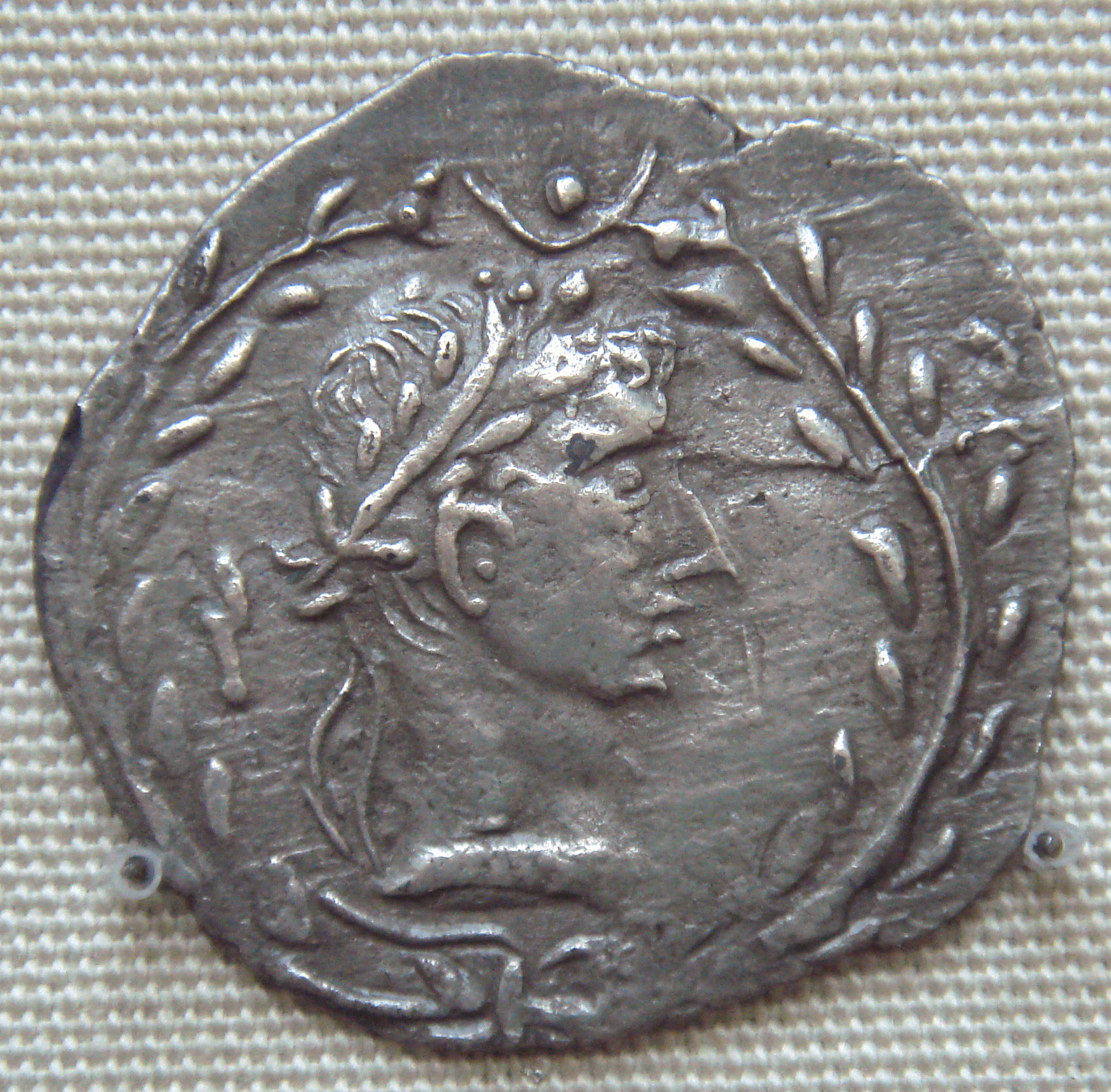
Coin of Himyar kingdom showing Roman influence and depicting a likeness of Augustus


It is noteworthy to pinpoint that the Red Sea was a key area in the international trade route between the Roman Empire and the Far East (generally referred to by the Romans as ‘India’).

This commerce was extremely important for the economy of the Roman empire and -in order to defend and promote this trade- Trajan occupied the northern region of western Arabia (recently further evidence has been discovered that Roman legions occupied Mada'in Saleh in the Hijaz Mountains area of northwestern Arabia, increasing the extension of the "Arabia Petraea" province) and promoted the creation of a Roman Client State in the actual Yemen/Aden territory (the Himyar kingdom).

Indeed in AD 106, the Romans conquered the Nabataeans and brought an end to the rule of King Rabel II. Under Roman control, Bostra —Rabel had shifted the Nabataean capital from Petra to Bostra— was renamed "Nea Traiane Bostra", after the emperor, and it was there that the base camp of the Third Cyrenaica Legion was established. For the next five years, Roman legionaries worked to fortify defense boundaries, establish control of the new province, and build the great road from Bostra to Aqaba —the "Via Nova Traiana"— which ran the length of the province. In 111 AD, Rome publicly announced the successful annexation of Roman Arabia and the completion of the great road, and issued Trajanic coinage advertising the annexation. The new province became one of Trajan's legacy in the Middle East.

Trajan also had good relations with the Himyar kingdom, located in the area of actual Yemen/Aden. The famous "Periplus of the Erythraean Sea" describes the close relationship between the king of this southeastern Arabia kingdom (named Charibael) and the Romans in the first century C.E.:

...And after nine days more there is Saphar, the metropolis, in which lives Charibael, lawful king of two tribes, the Homerites and those living next to them, called the Sabaites; through continual embassies and gifts, he is a friend of the (Roman) Emperors.


Charibael is usually identified with Kariba-il Watar Yuhan'im, who ruled Himyar sometime between AD 40 and 70 AD. According to the author of the Periplus, he is said to dwell in Saphar and to maintain friendship with the Roman emperors by means of "continual embassies and gifts"; he is said to exercise control over the towns of "Muza" (Mocha) and "Saua" (Taiz) in "Mapharitis" through a "vassal-chief" named "Cholaebus" (Kula'ib). From the Roman merchants calling at Mocha, he used to require tribute of "horses and sumpter-mules, vessels of gold and polished silver, finely woven clothing and copper vessels". In the Periplus was written that his realm included "Ocelis" at the Bab-el-Mandeb strait and the ruins at "Eudaemon Arabia".

During Trajan’s reign, the Romans established a legionary garrison on Farasan island (called "Portus Ferresanus" in Latin language), in the southern Red Sea off the coast of southern Arabia, possibly to guard the lucrative trade routes passing through the strait of Bab-el-Mandeb. Farasan—conjectured to be the southernmost point of the Roman Empire—may have originally been an outpost of the Nabataean Kingdom and initially administered from the Roman province of Arabia, but by 144 AD it was being governed from Egypt.

Probably the Romans used the garrison on the Farasan island to show support for the Himyar kingdom during Trajan years, against nearby enemies. This help was at the root behind the creation of "client states" by the Romans. How long this station lasted is uncertain from the scant archaeological record, but it was probably abandoned by the end of the Crisis of the Third Century (235–285). At the same time the friendly relations between Rome and the Himyar kingdom finished.

Sometime around 140 AD the old personal union between the Ḥimyarite Kingdom and the Kingdom of Saba seems to have broken, restoring Saba’s independence. Following this, the two kingdoms became increasingly hostile to each other, fighting wars on several occasions over the next 120 years. The breakup of this union may also have ended Roman influence in Ḥimyar, which stopped producing coins depicting the likeness of Augustus by the end of the 2nd century.

Finally it is noteworthy to pinpoint that the Romans -who mastered engineering knowledge for acqueducts- helped the Himyar kingdom to reinforce and maintain the famous "Marib Dam", according to the historian Theodore Mommsen.

Image of how was the original Marib Dam, reconstructed with Roman engineering knowledge


Indeed the dam was under the full control of the Ḥimyarites since Augustus times. They undertook further reconstruction, creating a structure 14 meters high with extensive waterworks at both the northern and southern ends, five spillway channels, two masonry-reinforced sluices, a settling pond, and a 1000-meter canal to a distribution tank. These extensive works seems to have been started at the beginning of the second century (exactly when Trajan ruled the Red Sea, with the "Himyar Kingdom Client State") and were totally finalized only around the end of the Third Century.

The Marib Dam allowed the irrigation of 25,000 acres (100 km2) and it was one of the most wonderful feats of engineering in the ancient world.

Sunday, April 4, 2021

CENTAURO DIVISION TENTATIVE TO INVADE ALGERIA IN 1943 KASSERINE PASS BATTLE

Only a few historians remember an episody of World War 2: the Axis attack inside Algeria during the famous Kasserine Pass Battle of February 1943. This was the only time when Algeria (in 1943 a french territory nicknamed "Algerie Francaise") was invaded -even if in a minimal "area"- by the Italian-Germans under Field-Marshal Rommel leadership.

Official US Map showing with red arrows the Centauro attacks toward Tebessa (and Bou Chebka) in eastern Algeria, on the red "Line of February 24"
The American force in the region was the II Corps, spearheaded by the 1st Armored Division. In charge of the Americans and operating semi-autonomously was Lieutenant General LLoyd Fredendall. He chose to command his corps from Tebessa, some 80 miles to the rear of his forward units (after the debacle of Kasserine Pass battle, Fredendall was relieved of command of II Corps by General Dwight Eisenhower, the Supreme Allied Commander in North Africa, and replaced by Major General George Patton on March 6, 1943).

In the Axis, Rommel began to cherish the dream of a spectacular action of all his forces towards Tebessa to try to reverse "the bulk of the allied troops from Algeria". The "Desert Fox" (nickname of Rommel) tried to force Kasserine's Pass in order to finally point to Tebessa. However, Hitler and his generals thwarted these plans as they were reluctant to embark on an action of this magnitude. Rommel was furious: he contacted the Italian Supreme Command which only on the evening of February 18 gave the go-ahead for the operation with italo-german armored divisions. However, the attack had to be conducted towards Thale and El Kef instead of Tebessa. According to Rommel, this decision was "an incredible example of myopia" The British Sixth Armored Division with numerous contingents of US infantry and artillery in support was positioned in Thala.

On the 20th, the german 10th and 15th Panzer Divisions with the italian 131st Armoured Centauro division conquered the Kasserine Pass inflicting a very heavy series of losses on the American troops. Over 4,000 Americans were taken prisoner, 200 wagons and hundreds of vehicles were burned, illuminating the African night, while the Axis units hoarded all kinds of rations and armaments that these inexperienced soldiers had at their disposal. Eisenhower enraged by the great defeat replaced Fridendall with the energetic Patton. Complete victory was now within reach: American troops faltered and fuel depots and warehouses began to be burned in the rear (mainly at Tebessa).

In terms of kilometers, the Kasserine Pass battle represented the largest defeat of US forces in all World War II, pushed back 140 km in a single week. But on this occasion, however, Rommel decided -for reasons that are still debated by historians- on late February 23/early February 24 to retire and return to the frenzied "Mareth line" in southern Tunisia.

Centauro tank destroyed, inspected by US troops after the Kasserine Pass battle


The Italian "131st Armoured Centauro Division" attack

The Centauro Division was composed of the:

131st Tank Regiment (13th, 14th & 15th Armored Battalions, with M14/41 tanks)
5th Bersaglieri Regiment (14th, 22nd & 24th Bersaglieri Battalions)
131st Artillery Regiment
132nd Anti-Tank Artillery Regiment
“Lodi” Recce Battalion (with AB41 Armored Cars)


On February 19, 1943 the Centauro Division & the German divisions were ordered by Field-Marshal Rommel to capture Kasserine Pass from elements of the U.S. 1st Armored Division. On February 20th, during the opening attack on the key American position of the town of Djebel, the 5th Bersaglieri Regiment made a frontal assault on the U.S. positions that lasted most of the morning and finally conquered the position, loosing the Regimental commander ( colonel Bonfatti) in the process. This action cracked open the Allied defenses, opening the road to Thala and Tebessa. By midday the accompanying Axis armored units poured through the pass, routing U.S. forces into the worst U.S. defeat of the Tunisian Campaign. The 5th Bersaglieri Regiment was complimented for their achievement by General Bulowius, commander of the "Assault Group" toward Tebessa, who sighted their actions as the instrumental event of the Axis victory.


In the way to Kasserine, on February 15 the famous general Rommel captured 50 tons of fuel and lubricants that the Americans had failed to destroy when partially defeated near Kasserine Pass. But even though he was pleased with his spoils, he was looking farther up the road, past Kasserine toward Tebessa, where the US II Corps was headquartered and where there were enormous dumps of fuel and supplies. If he captured Tebessa, his advance could swing all the way to the city of Bône on the eastern Algerian coast, cutting off the British—who were advancing on Tunis from Libya—from their supplies in Algeria. Kasserine Pass was the key to making these triumphs real.

Indeed on February 19, 1943, two Italo-German battle groups probed the American line of defense around the Kasserine Pass. "Kampfgruppe Deutsches Afrika Korps" (the German Afrika Corps Battle Group), including elements of the Italian Centauro Division, approached that morning from the west and, after skirmishing there, crossed the front of the American line, dismounted from their trucks in the foothills of Djebel Semmama, and prepared for the assault.

Exploratory Axis groups went from Thelepse and Feriana toward Tebessa, but stopped in the Bou Chebka area (inside Algeria territory, just a few miles from Tebessa), that was strongly defended by the Command Combat B (CCB).

In the afternoon the second battle group, from the 10th Panzer Division, arrived from the east and launched the attack on the American line. By early evening, the US 19th Engineer Regiment, defending Highway 17, was being infiltrated by groups of enemy infantry. A new German weapon, the Nebelwerfer six-barreled rocket mortar (soon to be nicknamed “Screaming Meemie” by the Americans), was hitting the engineers and the tanks and tank destroyers supporting the American line. Under fierce artillery bombardment, the line gave way during the night, with men at all points running away from the bombardment. The roads leading out of the north of the Kasserine Pass and the foothills on either side were beginning to fill with fleeing American soldiers.

Axis forces also made a breakthrough on Highway 13, where the Italians of the Centauro Division spearheaded the attack. In the early morning hours, the Italians pressed their offensive, broke through the remains of the American line, and continued up Highway 13 toward Tebessa.

At Tebessa (in the border of eastern Algeria, just 10 miles from Tunisia), preparations were being made to shift Fredendall’s headquarters out of harm’s way and to destroy the dumps of fuel, ammunition, and supplies in the nearby US Speedy Valley base area. Morale was slipping badly, including that of Fredendall himself.

A "Semovente"75/18 of the Centauro. Next to it, can be seen Field-Marshal Rommel (with his typical hat) on his desert military vehicle


US General Harmon, en route to the battlefield, would later comment on his journey to the front: “I have never forgotten that harrowing drive: It was the first—and only—time I ever saw an American army in full rout....... Jeeps, trucks, wheeled vehicles of every imaginable sort streamed up the road toward us, sometimes jammed two or even three abreast. It was obvious there was only one thing in the minds of the panic-stricken drivers—to get away from the front, to escape to someplace where there was no shooting.”

Harmon reached Tebessa and met Fredendall, who asked if the command post should be moved. Harmon said it should stay where it was. Fredendall then handed Harmon a typed sheet that assigned Harmon command of the 1st Infantry Division and the British 6th Armoured, the latter of which Fredendall did not control.

The next day the Kasserine Pass fell. The bersaglieri of the "Centauro" division brilliantly carried out the final assault. 2450 valid prisoners against 192 fallen: the Americans were harshly defeated for the first time in the WW2 African battleground, suffering the loss of many who were made POWs. Kesselring met Rommel on the hill conquered and the two marshals walking in the middle of an impressive amount of abandoned material, said: “We have a lot to learn from them,” said Rommel pointing out to the perfection of the American Supply/managerial system. Kesselring then answered: "but they too have something to learn from us!".

The 131st Centauro Armored Division, which at the time had only 23 tanks M14/41 and some "Semoventi" 75/18, and the Bersaglieri of the 5th and 7th Regiment, engaged in harsh close combat with the Americans (Colonel Luigi Bonfanti, commander of the 7th, heroically fell in combat receiving the 'Gold Medal'), while advancing toward Tebessa and the Bou Chebka Pass.

Rommel wrote in his memories that the "5th bersaglieri" of the Centauro Division won the US defenses in the Kasserine Pass and opened the road to attack Thalia and Tebessa, but lost his commander (Bonfanti).

But on the western side of the valley, Command Combat B (CCB) was blocking the road to Tebessa. Elements of the Centauro Division hit a CCB outpost early on the morning of February 21, and after a brisk fight, the outpost withdrew. The Afrika Korps group continued up Highway 13. The CCB defenders held firm that long day against repeated Italian and German attacks. That night "Panzergrenadier Regiment Afrika" (Afrika Korps motorized infantry) tried to flank CCB to the south near the Bou Chebka Pass, but in the darkness it ascended the wrong hill. Luck was beginning to swing toward the Americans.

Indeed after having broken through the defenses of the Kasserine Pass, FieldMarshal Rommel sent two groups toward the Algeria border: part of his forces along the road to Thala and another part towards the road to Tébessa. Apparently undecided on the best direction in which to exploit the success, the German "Desert Fox", after consultations with general Kesselring, who on 20 and 21 February stayed in Tunisia to try to coordinate the offensive and to push to attack in turn towards Pichon, kept the two groups divided (also separated by the course of the Hatab river -located in the middle of Kasserie Pass- whose main bridge had been destroyed by the American engineers). He remained with the main group of the 10th Panzer-Division of General von Broich marching with about 30 tanks, 20 self-propelled and two motorized battalions on the northernmost of the two roads, towards Thala and Le Kef, while an Italian-German mixed force (made mainly with the Centauro) under General Bülowius took the southern route towards Haïdra and Tébessa.

The next day, February 22, found the Italians and Germans of the second group pushing against two stubborn lines of Allied defense. They spent the day pounding away at Command Combat B, which was defending the road to Tebessa. But the group had been somewhat dispersed by the previous day’s maneuvers and could not pry the defenders out of their positions at Bou Chebka area.

Map showing the location of Bou Chebka, the place inside Algeria reached by the Italian-German Axis troops during the Kasserine Pass battle


Moreover, we must not forget the value of the “Grado” battalion of the Centauro: it had had an extremely difficult task; it had to conquer and then unblock the very armed “Pass” of Tefifila, which American and French troops were trying to defend at any cost; the conquest of that Pass, in fact, opened the way to central Algeria. It was an obligatory passage, between Jebel Alfa and Jebel Bou Dabbous.

After a strenuous struggle, which cost some losses to the "Grado" that also captured two entire Algerian units, that Pass with skilful nocturnal action was conquered, thus giving the 10th German armored division the opportunity to advance. It is worth mentioning the heroic behavior of Lieutenant Rodolfo Pampalone Morisani, who was the battalion's liaison officer and came from the 'Grenadiers of Sardinia'. In concert with the commander of the "Grado" battalion, Lieutenant of Vascello Ernesto De Brazzi, Lieutenant Morisani organized and conducted the night attack that surprised the enemy defenders of the western sector of the Pass of Tefifila, constituted, as mentioned above, by the two harsh hills of Gebel Alfa and Bou Dabouss (for weeks in vain attacked by the Superga Division, by Bersaglieri and by a unit of Italian Tunisian volunteers). In fact, these were well fortified positions, which rose to over 800 meters above sea level, dominating the extensive plain of Kairouan where low dunes rose that gave only a very modest shelter and were the only starting point for the attackers. The conquest of that Pass unlocked that stagnation situation and allowed the German 10th division to approach the outskirts of Thala (that was temporarily occupied).

Finally, the Axis forces (5th Bersaglieri, a Semovente group from Centauro and 15 Panzer) launched another assault on the U.S. position on the late morning of the 22 February toward Bou Chebka. Although the American defenders were pressed hard the line held and, by mid-afternoon, the U.S. infantry and tanks launched a counterattack that broke the combined German and Italian force. More than 400 Axis prisoners were taken as the counterattack was pressed into the Axis positions on late February 23. Rommel decided to stop the fightings for the Kasserine Pass area on February 24.

The battle was over.....it was a "tactical" victory for the Axis troops, but it was the last they obtained in Africa. According to US historian Brian John Murphy, the Centauro division overran a part of the US forces defending Highway 13 during the Battle of the Kasserine Pass: "Axis forces also made a breakthrough on Highway 13, where the Italians of the Centauro Division spearheaded the attack. In the early morning hours, the Italians pressed their offensive, broke through the remains of the American line, and continued up Highway 13 toward Tebessa."

The Centauro division on March 10, 1943 had only 30 combat-ready units (2 "semoventi" 75/18, 18 tanks M14 and 10 "autoblindo" AB41): on April 7, 1943 -after other "desperate" battles in Tunisia in which lost nearly all the remaining men and armaments- the ''131st Armoured Division Centauro'' was dissolved.

ADDENDUM

1) Video of the "Centauro Division" (made in July 1942, just before the Centauro was sent to north Africa):

Tuesday, March 2, 2021

ACTUAL NEOLATINS IN SERBIA

We all know that the presence of neolatin people in what is now Serbia has suffered huge reductions since the Middle Ages. The descendants of latin colonists, that mixed with local populations during the centuries of the Roman Empire, have nearly disappeared while being "assimilated" by the Slavs who settled in these territories after the seventh century.

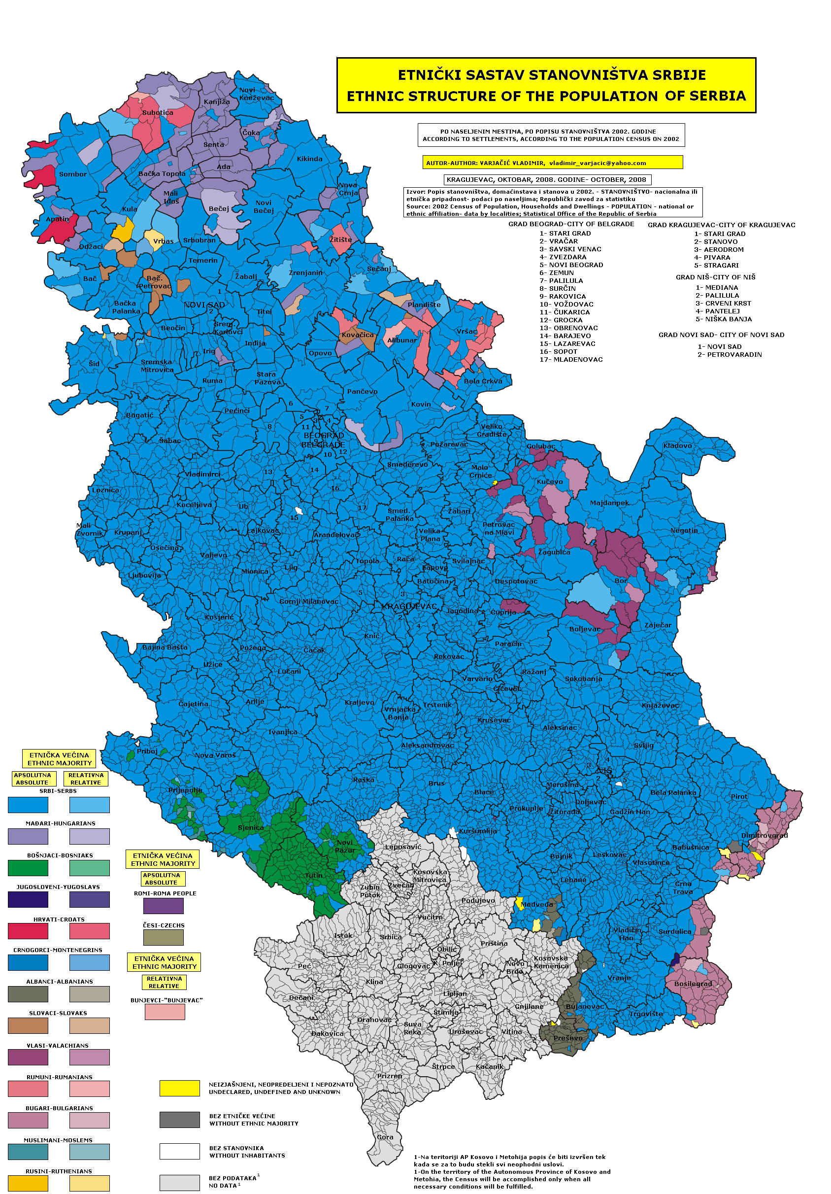
This reduction has been precisely detailed only since the XIX century, especially in the region of Timok (northeastern Serbia), as can be seen in the following maps:

2008 ethnic map of Serbia (in violet color the Timok Vlachs)


1860 ethnic map of Timok Vlachs (in light blue). Note their extension reaching the Morava & Danube river, while in the above 2008 map -after 150 years- they are reduced to small areas away from those rivers


Actually Serbia is home to three small neolatin (Vlach-Romanian) communities, as stated by Annemarie Sorescu:

The first are the "Romanians of Vojvodina" (Serbian Banat), officially recognized as a Romanian minority in Serbia.They have access to schooling, mass media and religious service in the Romanianlanguage. According to the last Serbian population census, of 2011, they number 29,332 persons and inhabit around 40 settlements in Central and Southern Vojvodina. Some of these settlements are already mentioned in medieval archives,others were established in the 18th or beginning of the 19th century, during the Austro-Hungarian colonization of the Banat. They speak dialectal variants of the Romanian language and have knowledge of the standard romanian language.

The second community are the "Bayash" or Rudari. They live dispersed throughout Serbia and the Balkans. Their mother tongue is Romanian, but they are considered "Roma" (gypsies) by the surrounding populations, because of their semi-nomadic way of life, mentality and physical characteristics. However, but their belonging to the Romanian nation has been intensely contest.

The third neolatin community are the "Vlachs of Timok" (Eastern Serbia), who speak archaic dialectal variants of Romanian. According to the last census, they number 35,330, but members of the community put forth unofficial estimates between 150,000 and 300,000. They are not officially recognized as a Romanian minority. Within the Vlach community there are divergences whether or not they belong to the Romanian nation, and whether or not they should merge, at a political level, with the Romanian minority in Vojvodina.

Today, most of the Vlachs have a dual, contextual or politicized identity: they register as Romanians, Vlachs or Serbs and accordingly, but not necessarily in an overlapping manner, they declare their mother tongue to be Serbian, Vlach or Romanian. Romania does not question the Vlachs” origin and considers them Romanians living in Serbia.

However, Serbia declares that “there are no concordance and sameness between the Romanian and the Vlach languages and their speakers” (Comments Government Serbia 2009). Until recently, they have not been granted any minority rights regarding the use of their mother tongue. Vlach has been restricted to family use, but even its transmission to the younger generation was endangered.

Nevertheless, 2013 saw the publication of the first grammar of Vlach, in 2014 the first textbook for Vlach was printed, and Vlach introduced as an optional object in primary schools. In September 2015 the Vlach National Council adopted the standardization of the Vlach language.

Finally, according to the results of the 2011 census Vlachs are concentrated in three districts in Eastern Serbia: in Bor where they make up 10.65% of the population, in Branicevo where they make up 21.7%, and in Zajecar district where they make up 21.5%. In these same three districts the number of those who declared themselves as Romanians is less than one per cent - 0.63% in Bor, 0.4% in Branicevo and 0.26% in the Zajecar district. What strikes more is the reduction of Vlachs and Romanians since the 1948 census: in that census there were 93440 Vlachs and 63130 Romanians, while in the 2011 census there are only 35330 Vlachs and 29332 Romanians!

It seems that the process of disappearance of the neolatin populations in Serbia keeps going on and on and on and on.......

The historical "bridge" between Romanians and Dalmatian Italians

There was a continuum of romance speaking populations in Europe at the end of the Western Roman Empire, from Portugal and Spain to France and Italy: this continuum reached the Balkans until the Danube river delta, from Italian Istria until the Romanian Dobrugia.

But actually there it is a "hole" of this continuum in the area that was former Yugoslavia (Slovenia, Croatia, Bosnia-Herzegovina and Serbia), because of the Slav invasions that happened during the early Middle Ages. However for many centuries this hole between Italy and Romania was partially occupied by a kind of "bridge" of neolatin populations (usually called "Vlachs", a word from latin 'vallum', meaning 'people of the Roman vallum' near the barbarian borders of the Western Roman empire) during the late Middle Ages until the Renaissance centuries. These Vlachs lived in the mountains of the western Balkans, but were slowly "assimilated" by the Slavs and actually they have practically disappeared, leaving only some evidences of themselves in the names of the Balkan topography & history (like "Romanija", "Stari Vlah", etc..).

Map showing the remains of the "Bridge" (Romanija Planina & Stari Vlah) in the XIII century, between the neolatin territories of Ragusa Republic & Spalato of the Dalmatian Italians and those of the Valko (Vojvodina) & Kucso (Timok)


Indeed Ilona Czamańska wrote in "Vlachs and Slavs in the Middle Ages and Modern Era” (Res Historica, 41, (Lublin, 2016), 19) that: "The majority of Serbs from the Republika Srpska of modern Bosnia is of Vlach origin, as well as the majority of the population from Bosnia and Herzegovina in general." This fact is clearly related to the historical bridge -now disappeared- that existed until the Middle Ages between the romance speaking Romanians and the Italian populations in Dalmatia and Istria.

The following are excerpts -related to this "bridge"- from an essay written by Octavian Ciobanu (Professor of Iasu University) and titled "The Heritage of Western Balkan Vlachs":

A lot of Latin or Vlach place names still resist until today in Western Balkans. Jirecek wrote about the Vlach impressive presence in Montenegro, Herzegovina and Dalmatia in a period which lasted from the XIIIth to the XVIth centuries.The Serbian documents from the 12th to the 15th centuries revealed a large number of Vlach placenames and Vlach personal names which are still in use by the Slavs of the Western Balkans. The Romanian character of the language of these Vlachs is generally recognized.

According to Stelian Brezeanu, among the toponyms attesting the presence of the Romanic element in the region, there are two that have an importance: Palaioblacoi and Stari Vlah. Palaioblacoi is attested in Thessaly (later Μεγάλη Βλαχία/Megali Vlahia) and the second toponym, Stari Vlah, is attested in the Medieval Serbia and in Herzegovina: “It was a region inside of the Kingdom of the Nemanids that attached the Kopaonik Mountains to the Romanija Mountains, around the city of Sarajevo. That region had as centre the Drina and the Lim rivers valley.”

Next to Stari Vlah it is Romanija. This area has the mountain still called Romanja.Therefore, the region of Stari Vlah belonged to a more extended area, intensively romanised at the end of the antiquity.Ştefan Stareţu writes that “it is clear that Stari Raska comes from Stari Vlaska, with a rothacism, and Raska from Vlaska (this is exemplified by the double name of Banat, as Vlaska or Raska)”. He also advances a hypothesis: “The Serbs and Vlachs are probably a single ethnic substance, constructed in the Balkan Peninsula as a unity in the 8th-14th century.”


Furthermore, according to Ilona Czamańska the Vlach population was already established in the western Balkans during the migration of Slavs. But she pointed out that both ethnic groups occupying the same land were not in conflict. Slavs, as farmers, occupied lands in the valleys, which were suitable for them, while Vlachs exploited mountains. Slavs, next to agriculture, also engaged in breeding, but did not practice transhumance pastoralism, which was the domain of the Vlachs. For the Slavs the land and the right to its cultivation and ownership was most important, for the Vlachs the ownership of land did not matter as long as the mountains were common property. The element, which bound their community together, was not the land, but family relationships and the sense of belonging to the same "clan".

In the Middle Ages the Vlachs lived in most of the mountain areas in the western Balkans up to the Adriatic coast. In the Middle Ages, the territory between the rivers Lim and Drina in the west, and Raska and Studenica in the east, was called “Old Wallachia” (Stari Vlah), and the Orthodox Church province of the Rasca – “eparchy Old Wallachian”.

In the Serbia of the Nemanjić dinasty (1166-1371) and the states that have later arisen on its ruins, the Vlachs created a fairly closed community because of their special privileged status, in contrast to the rest of Slavic peasant population. Mixed marriages with representatives of other social classes, especially the peasant population, were very difficult here. Despite that, here the processes of Slavisation and assimilation proceeded very quickly. It was also facilitated because of the vanishing of the areas where the Vlach shepherds could wander, because of the distribution of the mountain areas to particular owners. Vlachs defended themselves against dependence for example by buying pastures, which resulted in their definitive transition to semi-sedentary and sedentary life.

The Knez and provincial governors (often Vlach ones) became major landowners, entering the group of nobles and even the aristocracy of Serbia. Among the Slavic Balkan rulers many had Vlach roots – most probably the families Balšić, Hrvatinić – Kosača, and perhaps also Mrnjavcević. Already the earliest records of the names of the Vlachs as well as the names of localities preserved in the sources of the 13th century show a hybrid combination of Vlach and Slav element. Even then, many Vlach names were Slavic, often with Romanian endings (i.e. Dragul, Radul and Bogdan and afterwards even Milutin, Vukašin and Momcil).

Starting from the 14th century the term “Vlach” began to lose its ethnical meaning in favour of a societal meaning in the areas of Serbia and Bosnia and Herzegovina. In these areas the Vlachs were strongly mixed with the Slavic population and the name “Vlach” was frequently used interchangeably with the term “Slav”.

In the "bridge", Slavisation (in fact Serbisation) of the Vlachs was also encouraged by the period of the Ottoman rule. As Orthodox, Vlachs belonged to the same millet as Serbs, and after the reconstruction of the Serbian Patriarchate of Peć they were subordinated to civil authority of the Serbian patriarch. Thus, Vlachs were integrated with Serbs very quickly, especially that the religious affiliation was the main identifier. The persons who belonged to the Serbian Orthodox Church were called by the name of Serbs, not only in the lands which were traditionally Serbian, also in Bosnia. This process was intensified by the fact that many Vlachs abandoned their activities, especially since enclosed social classes did not exist in the Ottoman state.

Actually -according to Marian Wenzel- the majority of the population from Bosnia and Herzegovina in general is of Vlach origin.

Map showing the location (with small points) of the 'Stecci', medieval funerary monuments, in an area that is very similar to the one of the "historical bridge". Note that the easternmost 'Stecci' are located in Serbia's "Stari Vlah" and the westernmost are near the Republic of Venice's Zara area (linking -as a kind of "bridge" through Serbia and Bosnia/Herzegovina- western Romania and Italy's Dalmatia)


Indeed the medieval Vlachs (called often Aromanians) of Herzegovina are considered authors of the famous funerary monuments with petroglyphs (usually called "Stecci") from Herzegovina and surrounding countries. The theory of the Vlach origin of these 'Stecci' was proposed by Bogumil Hrabak (1956) and Marian Wenzel and more recently was supported by the archeological and anthropological researches of skeleton remains from the graves under these 'Stećci'. For Wenzel the Vlachs did not continue to create other 'Stecci' since their conversion -in the sixteenth century- to moslem religion because of Turks domination.

The theory is much older and was first proposed by Arthur Evans in his work "Antiquarian Researches in Illyricum" (1883): while doing research with Felix von Luschan on 'Stecci' graves around Konavle, he found that a large number of skulls were not of Slavic origin but similar to older romanised Illyrian population, as well as noting that Ragusa memorials recorded those parts inhabited by the Vlachs until the 15th century. In other words: these 'Stecci' made by neolatins confirm the existence of this "bridge" betweeen Dalmatia and "Stari Vlah"

Last but not least, we have to remember that in the area of southern Croatia and internal Dalmatia these Vlachs -who were present in the early Middle Ages- were called 'Maurovlachs', or 'Morlachs'(Morlacchi) by the Italians, and they relatively quickly succumbed to Slavisation and Catholic faith. They differentiated themselves from the rest of society through their social status, which took on a special meaning in these lands. In the 17th and 18th centuries the term 'Morlachs' determined both Slavisised Vlachs from the area of Dalmatia, as well as Croatian peasants who were mixed with Dalmatian Italians (and who actually speak a croatian dialect -called "Chacavian"- that has more than 50% of words loaned from latin & romance languages).

In a few final words: The neolatin "bridge" (between Italy and Romania) existed from the barbarian invasions until the first Renaissance centuries, remaining in a few isolated mountain areas until the XVIII century: it seems to have disappeared with the end of the "Repubblica di Venezia" and the beginning of the 'nationalism' in the Balkans. But if we include in the "bridge" also the Dalmatian Italians of coastal Dalmatia, we must remember that the last speaker of this autochtonous Dalmatian language (Tuone Udaina) died in 1898 in Veglia (actual Krk) and so the "bridge" remains survived in some way until the XIX century's end.

However -according to Italian historians like Della Volpe- a legacy of this "bridge" can be seen in the existence of the Republic of Bosnia & Herzegovina, populated mainly by descendants of the romanised populations who created the worldwide famous "Stecci".